Property Record
351 Kenyon Rd, Suffolk, VA 23434

Current Lease Availabilities
NEARBY LISTINGS FOR SALE OR LEASE
Property Detail
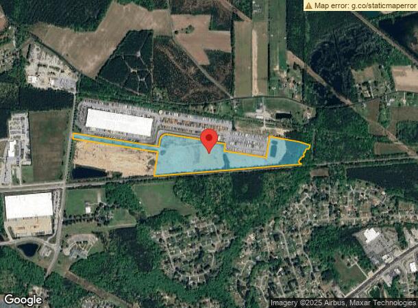
351 Kenyon Rd
250910000
RESIDUE PARCEL,MCDONALD VENTURES XXV LLC PLAT
Commercialacreage
Suffolk City
X
Virginia
5101560210D
33.65 AC
2025
South Suffolk
2025
Hampton Roads
075404
Virginia Beach-Chesapeake-Norfolk, VA-NC
DEMOGRAPHICS near 351 Kenyon Rd
1 mile
3 mile
5 mile
2024 Total Population
1,630
9,957
38,752
2029 Population
1,799
11,092
43,320
Pop Growth 2024-2029
+ 10.37%
+ 11.40%
+ 11.79%
Average Age
42
42
39
2024 Total Households
639
3,938
14,936
HH Growth 2024-2029
+ 10.64%
+ 11.73%
+ 12.20%
Median Household Inc
$84,280
$81,731
$64,111
Avg Household Size
2.60
2.50
2.50
2024 Avg HH Vehicles
2.00
2.00
2.00
Median Home Value
$267,777
$284,164
$257,654
Median Year Built
1968
1976
1982
Nearby Places
Map Layers
Map Styles
 Street
 Aerial
Transit
 Traffic
 Biking
Places
Listings with unknown addresses are not visible on the map
- Restaurants
- Banks
- Shops
- Fitness
- Groceries
PUBLIC TRANSPORTATION
AIRPORT
Norfolk International
Drive
Walk
Distance
Norfolk International
51 min
33.5 mi
Newport News/Williamsburg International
Drive
Walk
Distance
Newport News/Williamsburg International
61 min
39.7 mi
Freight Ports
Virginia Port Authority - Portsmouth
Drive
Walk
Distance
Virginia Port Authority - Portsmouth
41 min
26.4 mi
Nearby Properties
Address
Land Use
TOTAL SIZE
Lot Size
Zoning
Address
Land Use
TOTAL SIZE
Lot Size
Zoning
525 SF
161.67 AC
LIGHT INDU
Address
Land Use
TOTAL SIZE
Lot Size
Zoning
4,800 SF
71.72 AC
HEAVY INDU
Address
Land Use
TOTAL SIZE
Lot Size
Zoning
336,960 SF
27.70 AC
LIGHT INDU
Address
Land Use
TOTAL SIZE
Lot Size
Zoning
350,550 SF
21 AC
HEAVY INDU
Address
Land Use
TOTAL SIZE
Lot Size
Zoning
1,500 SF
69.49 AC
RES LOW-ME
Address
Land Use
TOTAL SIZE
Lot Size
Zoning
10 AC
RES LOW-ME
Address
Land Use
TOTAL SIZE
Lot Size
Zoning
12,927 SF
2.67 AC
RESIDENTIA
Address
Land Use
TOTAL SIZE
Lot Size
Zoning
58,439 SF
15.27 AC
RES LOW-ME
Address
Land Use
TOTAL SIZE
Lot Size
Zoning
33,200 SF
41.33 AC
OFFICE-INS
Address
Land Use
TOTAL SIZE
Lot Size
Zoning
86,213 SF
61.69 AC
RES LOW-ME
Address
Land Use
TOTAL SIZE
Lot Size
Zoning
54,100 SF
18.51 AC
HEAVY INDU
Address
Land Use
TOTAL SIZE
Lot Size
Zoning
840 SF
133.62 AC
HEAVY INDU
The World's #1 Commercial Real Estate Marketplace
Connect with us
© 2026 CoStar Group
The information above has been obtained from sources believed reliable. While we do not doubt its accuracy we have not verified it and make no guarantee, warranty or representation about it. It is your responsibility to independently confirm its accuracy and completeness. Any projections, opinions, assumptions, or estimates used are for example only and do not represent the current or future performance of the property. The value of this transaction to you depends on tax and other factors which should be evaluated by your tax, financial, and legal advisors. You and your advisors should conduct a careful, independent investigation of the property to determine to your satisfaction the suitability of the property for your needs.