Property Record
37631 6Th St E, Palmdale, CA 93550
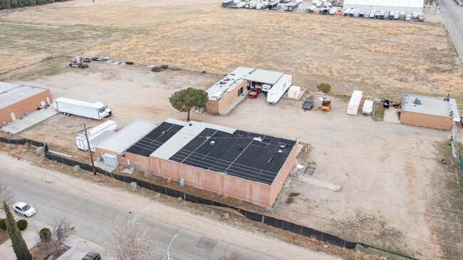

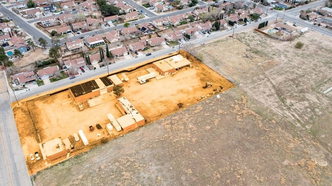

Property Detail
37631 6Th St E
3010-019-011
SUB OF N 1/2 OF SEC 35 T 6N R 12W LOT (EX OF ST) COM W ON S LINE OF LOT 3, 446.92 FT FROM W LINE OF S P R R R/W TH W ON SD S LINE 546.84 FT TH N 0 26'55 WSEE ASSESSOR MAPBOOK FOR MISSING PORTIONTH S 0 26'55 E TO BEG PART OF LOT 3
Lightindustrial
LOS ANGELES
PDM1
California
C and X Area of minimal flood hazard, usually depicted on FIRMs as above the 500-year flood level.
3,446
2024
2.82 AC
2025
Antelope Valley
910404
Los Angeles
8,036 SF
Los Angeles-Long Beach-Glendale, CA
NEARBY LISTINGS FOR SALE OR LEASE
DEMOGRAPHICS near 37631 6Th St E
1 mile
3 mile
5 mile
2025 Total Population
16,379
81,825
140,115
2030 Population
16,648
81,614
139,532
Pop Growth 2025-2030
+ 1.64%
(0.26%)
(0.42%)
Average Age
35
36
37
2025 Total Households
5,021
24,298
40,165
HH Growth 2025-2030
+ 1.81%
(0.28%)
(0.48%)
Median Household Inc
$54,925
$65,249
$74,354
Avg Household Size
3.20
3.30
3.40
2025 Avg HH Vehicles
2.00
2.00
2.00
Median Home Value
$370,823
$399,112
$436,852
Median Year Built
1984
1985
1987
Nearby Places
Map Layers
Map Styles
 Street
 Aerial
Transit
 Traffic
 Biking
Places
Listings with unknown addresses are not visible on the map
- Restaurants
- Banks
- Shops
- Fitness
- Groceries
PUBLIC TRANSPORTATION
COMMUTER RAIL
Palmdale (Antelope Valley Line - Southern California Regional Rail Authority (Metrolink))
Drive
Walk
Distance
Palmdale (Antelope Valley Line - Southern California Regional Rail Authority (Metrolink))
5 min
2.1 mi
Vincent Grade/Acton (Antelope Valley Line - Southern California Regional Rail Authority (Metrolink))
Drive
Walk
Distance
Vincent Grade/Acton (Antelope Valley Line - Southern California Regional Rail Authority (Metrolink))
11 min
6.1 mi
AIRPORT
Bob Hope
Drive
Walk
Distance
Bob Hope
58 min
48.2 mi
SALE & LEASE HISTORY
LISTING DATE
SALE/LEASE

Oct 18, 2018
For Sale
Oct 10, 2021
For Sale
Mar 17, 2025
For Sale
Jul 19, 2019
For Sale
Nearby Properties
Address
Land Use
TOTAL SIZE
Lot Size
Zoning
Address
Land Use
TOTAL SIZE
Lot Size
Zoning
358,828 SF
26.23 AC
PDR17000
Address
Land Use
TOTAL SIZE
Lot Size
Zoning
130,392 SF
26.91 AC
PDCPD*
Address
Land Use
TOTAL SIZE
Lot Size
Zoning
167,366 SF
15.36 AC
PDC3
Address
Land Use
TOTAL SIZE
Lot Size
Zoning
88,750 SF
9.28 AC
PDM1 1/2*
Address
Land Use
TOTAL SIZE
Lot Size
Zoning
50,735 SF
PDCPD
Address
Land Use
TOTAL SIZE
Lot Size
Zoning
78,492 SF
3.25 AC
PDCPD
Address
Land Use
TOTAL SIZE
Lot Size
Zoning
139,513 SF
4.07 AC
PDCPD
Address
Land Use
TOTAL SIZE
Lot Size
Zoning
60,644 SF
3.89 AC
PDMX*
Address
Land Use
TOTAL SIZE
Lot Size
Zoning
103,503 SF
3.61 AC
PDC2
Address
Land Use
TOTAL SIZE
Lot Size
Zoning
64,818 SF
2.30 AC
PDCP
Address
Land Use
TOTAL SIZE
Lot Size
Zoning
221,827 SF
14.90 AC
PDRPD10U-R
Address
Land Use
TOTAL SIZE
Lot Size
Zoning
157,021 SF
PDRN4
Address
Land Use
TOTAL SIZE
Lot Size
Zoning
59,577 SF
0.59 AC
PDR17000
Address
Land Use
TOTAL SIZE
Lot Size
Zoning
209,328 SF
6.35 AC
PDC3-RPD15
Address
Land Use
TOTAL SIZE
Lot Size
Zoning
69,555 SF
7.55 AC
PDMPD*
Address
Land Use
TOTAL SIZE
Lot Size
Zoning
71,394 SF
2.93 AC
PDCPD*
Address
Land Use
TOTAL SIZE
Lot Size
Zoning
76,609 SF
3.61 AC
PDM2
Address
Land Use
TOTAL SIZE
Lot Size
Zoning
36,033 SF
3.81 AC
PDMPD*
Address
Land Use
TOTAL SIZE
Lot Size
Zoning
144,471 SF
12.96 AC
PDCPD-MPD*
Address
Land Use
TOTAL SIZE
Lot Size
Zoning
80,981 SF
7.11 AC
PDC3
Address
Land Use
TOTAL SIZE
Lot Size
Zoning
55,079 SF
1.98 AC
PDCPD*
Address
Land Use
TOTAL SIZE
Lot Size
Zoning
71,974 SF
3.83 AC
PDCPD*
Address
Land Use
TOTAL SIZE
Lot Size
Zoning
377,382 SF
8.99 AC
PDMP
Address
Land Use
TOTAL SIZE
Lot Size
Zoning
207,582 SF
18.74 AC
PDR1*
Address
Land Use
TOTAL SIZE
Lot Size
Zoning
61,883 SF
4.10 AC
PDMPD*
Address
Land Use
TOTAL SIZE
Lot Size
Zoning
133,410 SF
12.66 AC
PDMPD*
Address
Land Use
TOTAL SIZE
Lot Size
Zoning
115,800 SF
11.51 AC
PDCPD-MPD*
Address
Land Use
TOTAL SIZE
Lot Size
Zoning
47,224 SF
2.10 AC
PDCPD*
Address
Land Use
TOTAL SIZE
Lot Size
Zoning
49,138 SF
2.30 AC
PDCP
Address
Land Use
TOTAL SIZE
Lot Size
Zoning
81,790 SF
5.70 AC
PDR1*
The World's #1 Commercial Real Estate Marketplace
Connect with us
© 2026 CoStar Group
The information above has been obtained from sources believed reliable. While we do not doubt its accuracy we have not verified it and make no guarantee, warranty or representation about it. It is your responsibility to independently confirm its accuracy and completeness. Any projections, opinions, assumptions, or estimates used are for example only and do not represent the current or future performance of the property. The value of this transaction to you depends on tax and other factors which should be evaluated by your tax, financial, and legal advisors. You and your advisors should conduct a careful, independent investigation of the property to determine to your satisfaction the suitability of the property for your needs.