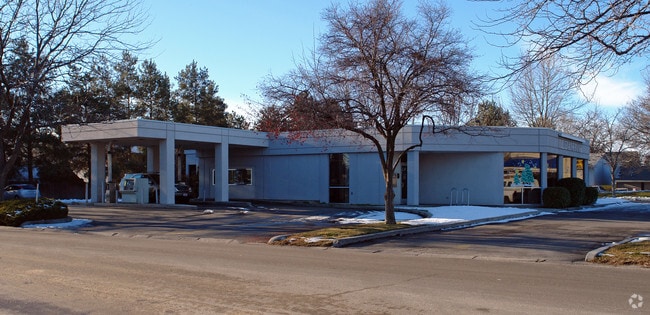
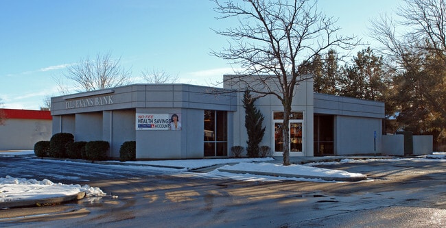
Property Record
3845 W State St, Boise, ID 83703

NEARBY LISTINGS FOR SALE OR LEASE
Property Detail
3845 W State St
Boise City, ID
Ralph Jones Sub
R4726000168
PAR #0168 OF LOT 15 RALPH JONES SUB & OF NE4 SEC 32 4N 2E #0166-B
Commercialbuilding
Ada
X
Idaho
16001C0188J
15
2024
0.70 AC
2025
North Boise
000401
Boise City/Nampa
4,319 SF
DEMOGRAPHICS near 3845 W State St
1 Mile
3 Mile
5 Mile
2024 Total Population
12,869
92,996
202,864
2029 Population
14,526
105,190
229,622
Pop Growth 2024-2029
+ 12.88%
+ 13.11%
+ 13.19%
Average Age
39
40
40
2024 Total Households
5,517
41,109
87,191
HH Growth 2024-2029
+ 13.10%
+ 13.53%
+ 13.60%
Median Household Inc
$64,337
$62,764
$64,421
Avg Household Size
2.20
2.10
2.20
2024 Avg HH Vehicles
2.00
2.00
2.00
Median Home Value
$460,185
$462,894
$442,391
Median Year Built
1978
1980
1984
Nearby Places
Map Layers
Map Styles
 Street
 Aerial
- Restaurants
- Banks
- Shops
- Fitness
- Groceries
PUBLIC TRANSPORTATION
AIRPORT
Boise Air Trml/Gowen Field
DRIVE
WALK
Distance
Boise Air Trml/Gowen Field
30 min
10.8 mi
Freight Ports
Port of Portland
DRIVE
WALK
Distance
Port of Portland
478 min
432.3 mi
Nearby Properties
Address
Land Use
TOTAL SIZE
Lot Size
Zoning
Address
Land Use
TOTAL SIZE
Lot Size
Zoning
369,584 SF
1 AC
ZC-259
Address
Land Use
TOTAL SIZE
Lot Size
Zoning
434,370 SF
0.56 AC
ZC-259
Address
Land Use
TOTAL SIZE
Lot Size
Zoning
129,663 SF
0.92 AC
ZC-259
Address
Land Use
TOTAL SIZE
Lot Size
Zoning
13.90 AC
R-2
Address
Land Use
TOTAL SIZE
Lot Size
Zoning
4.02 AC
C-2/DA
Address
Land Use
TOTAL SIZE
Lot Size
Zoning
279,694 SF
2.09 AC
ZC-264
Address
Land Use
TOTAL SIZE
Lot Size
Zoning
402,504 SF
5.78 AC
ZC-259
Address
Land Use
TOTAL SIZE
Lot Size
Zoning
334,334 SF
3.21 AC
ZC-259
Address
Land Use
TOTAL SIZE
Lot Size
Zoning
156,000 SF
4.57 AC
ZC-241
Address
Land Use
TOTAL SIZE
Lot Size
Zoning
207,033 SF
10.67 AC
ZC-243
Address
Land Use
TOTAL SIZE
Lot Size
Zoning
204,396 SF
0.82 AC
ZC-261
Address
Land Use
TOTAL SIZE
Lot Size
Zoning
366,126 SF
0.82 AC
ZC-259
Address
Land Use
TOTAL SIZE
Lot Size
Zoning
223,171 SF
0.85 AC
ZC-264
Address
Land Use
TOTAL SIZE
Lot Size
Zoning
225,032 SF
12.75 AC
R-3
Address
Land Use
TOTAL SIZE
Lot Size
Zoning
359,820 SF
1.79 AC
ZC-259
Address
Land Use
TOTAL SIZE
Lot Size
Zoning
459,218 SF
1.79 AC
ZC-241
Address
Land Use
TOTAL SIZE
Lot Size
Zoning
159,859 SF
0.80 AC
ZC-264
Address
Land Use
TOTAL SIZE
Lot Size
Zoning
245,000 SF
12.28 AC
R-2
Address
Land Use
TOTAL SIZE
Lot Size
Zoning
205,522 SF
0.82 AC
ZC-259
Address
Land Use
TOTAL SIZE
Lot Size
Zoning
276,099 SF
8.70 AC
ZC-261
Address
Land Use
TOTAL SIZE
Lot Size
Zoning
216,371 SF
0.78 AC
ZC-261
Address
Land Use
TOTAL SIZE
Lot Size
Zoning
151,285 SF
9.54 AC
R-1C
Address
Land Use
TOTAL SIZE
Lot Size
Zoning
189,100 SF
0.60 AC
ZC-259
Address
Land Use
TOTAL SIZE
Lot Size
Zoning
222,379 SF
1.37 AC
M
Address
Land Use
TOTAL SIZE
Lot Size
Zoning
150,584 SF
6.77 AC
M
Address
Land Use
TOTAL SIZE
Lot Size
Zoning
182,950 SF
0.41 AC
ZC-259
Address
Land Use
TOTAL SIZE
Lot Size
Zoning
96,969 SF
2 AC
ZC-261
Address
Land Use
TOTAL SIZE
Lot Size
Zoning
211,039 SF
12.21 AC
ZC-243
Address
Land Use
TOTAL SIZE
Lot Size
Zoning
259,231 SF
1.72 AC
ZC-259
Address
Land Use
TOTAL SIZE
Lot Size
Zoning
247,435 SF
2.90 AC
ZC-261
The World's #1 Commercial Real Estate Marketplace
Connect with us
© 2026 CoStar Group
The information above has been obtained from sources believed reliable. While we do not doubt its accuracy we have not verified it and make no guarantee, warranty or representation about it. It is your responsibility to independently confirm its accuracy and completeness. Any projections, opinions, assumptions, or estimates used are for example only and do not represent the current or future performance of the property. The value of this transaction to you depends on tax and other factors which should be evaluated by your tax, financial, and legal advisors. You and your advisors should conduct a careful, independent investigation of the property to determine to your satisfaction the suitability of the property for your needs.