Property Record
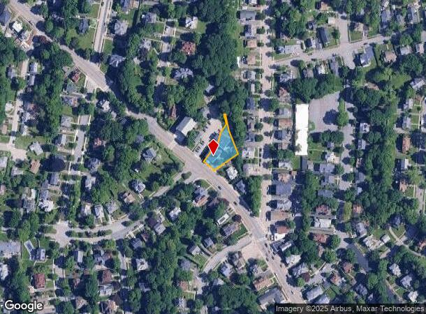
4 Ureco Ter, Worcester, MA 01602
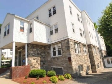
Property Detail
4 Ureco Ter
WORC-000011-000018-000021
WORCESTER
Apartment
Massachusetts
RL-7
21
B and X Area of moderate flood hazard, usually the area between the limits of the 100-year and 500-year floods.
0.30 AC
2025
Salisbury Street
2025
Boston
730901
Worcester, MA
NEARBY LISTINGS FOR SALE OR LEASE
DEMOGRAPHICS near 4 Ureco Ter
1 mile
3 mile
5 mile
2025 Total Population
16,552
139,987
234,328
2030 Population
16,549
141,063
237,299
Pop Growth 2025-2030
(0.02%)
+ 0.77%
+ 1.27%
Average Age
40
38
39
2025 Total Households
6,012
53,290
91,537
HH Growth 2025-2030
(0.13%)
+ 0.84%
+ 1.37%
Median Household Inc
$111,839
$67,173
$76,211
Avg Household Size
2.40
2.40
2.40
2025 Avg HH Vehicles
2.00
1.00
2.00
Median Home Value
$457,889
$395,842
$394,137
Median Year Built
1947
1948
1952
Nearby Places
Map Layers
Map Styles
 Street
 Aerial
Layers
 Traffic
 Biking
Places
Listings with unknown addresses are not visible on the map
- Restaurants
- Banks
- Shops
- Fitness
- Groceries
PUBLIC TRANSPORTATION
COMMUTER RAIL
Drive
Walk
Distance
5 min
2.4 mi
Worcester (Framingham/Worcester Line - Massachusetts Bay Transportation Authority Commuter Rail (Purple Line))
Drive
Walk
Distance
Worcester (Framingham/Worcester Line - Massachusetts Bay Transportation Authority Commuter Rail (Purple Line))
5 min
2.8 mi
AIRPORT
Worcester Regional
Drive
Walk
Distance
Worcester Regional
8 min
3.4 mi
Freight Ports
Port of Boston
Drive
Walk
Distance
Port of Boston
65 min
47.3 mi
Nearby Properties
Address
Land Use
TOTAL SIZE
Lot Size
Zoning
Address
Land Use
TOTAL SIZE
Lot Size
Zoning
669,637 SF
17.46 AC
BG-6
Address
Land Use
TOTAL SIZE
Lot Size
Zoning
49.51 AC
IN-S
Address
Land Use
TOTAL SIZE
Lot Size
Zoning
381,440 SF
2.74 AC
BG-6
Address
Land Use
TOTAL SIZE
Lot Size
Zoning
612,538 SF
3.98 AC
BG-6
Address
Land Use
TOTAL SIZE
Lot Size
Zoning
20.01 AC
BG-2
Address
Land Use
TOTAL SIZE
Lot Size
Zoning
244,486 SF
42.64 AC
RL-7
Address
Land Use
TOTAL SIZE
Lot Size
Zoning
142.98 AC
Address
Land Use
TOTAL SIZE
Lot Size
Zoning
51.05 AC
BO-1
Address
Land Use
TOTAL SIZE
Lot Size
Zoning
3.85 AC
RG-5
Address
Land Use
TOTAL SIZE
Lot Size
Zoning
117,645 SF
3.11 AC
BO-1
Address
Land Use
TOTAL SIZE
Lot Size
Zoning
311,604 SF
2.37 AC
MG-2
Address
Land Use
TOTAL SIZE
Lot Size
Zoning
16,404 SF
10.80 AC
RS-10
Address
Land Use
TOTAL SIZE
Lot Size
Zoning
1,760 SF
105.54 AC
ML10
Address
Land Use
TOTAL SIZE
Lot Size
Zoning
157,385 SF
3.45 AC
BG-6
Address
Land Use
TOTAL SIZE
Lot Size
Zoning
291,410 SF
21.73 AC
RL-7
Address
Land Use
TOTAL SIZE
Lot Size
Zoning
15.42 AC
RG-5
Address
Land Use
TOTAL SIZE
Lot Size
Zoning
19,319 SF
10.67 AC
RG-5
Address
Land Use
TOTAL SIZE
Lot Size
Zoning
177.12 AC
RL-7
Address
Land Use
TOTAL SIZE
Lot Size
Zoning
3.55 AC
RG-5
Address
Land Use
TOTAL SIZE
Lot Size
Zoning
194,264 SF
4.32 AC
BL-1
Address
Land Use
TOTAL SIZE
Lot Size
Zoning
69.46 AC
RS-7
Address
Land Use
TOTAL SIZE
Lot Size
Zoning
68.34 AC
ML10
Address
Land Use
TOTAL SIZE
Lot Size
Zoning
3.43 AC
ML10
Address
Land Use
TOTAL SIZE
Lot Size
Zoning
3.97 AC
BG-6
Address
Land Use
TOTAL SIZE
Lot Size
Zoning
37,093 SF
5.41 AC
RG-5
Address
Land Use
TOTAL SIZE
Lot Size
Zoning
181,408 SF
1.50 AC
BG-6
Address
Land Use
TOTAL SIZE
Lot Size
Zoning
643,250 SF
35.17 AC
RL-7
Address
Land Use
TOTAL SIZE
Lot Size
Zoning
175,200 SF
2.26 AC
BL-1
Address
Land Use
TOTAL SIZE
Lot Size
Zoning
286,338 SF
33.45 AC
RL-7
Address
Land Use
TOTAL SIZE
Lot Size
Zoning
120,732 SF
28.92 AC
RS-10
The World's #1 Commercial Real Estate Marketplace
Connect with us
© 2026 CoStar Group
The information above has been obtained from sources believed reliable. While we do not doubt its accuracy we have not verified it and make no guarantee, warranty or representation about it. It is your responsibility to independently confirm its accuracy and completeness. Any projections, opinions, assumptions, or estimates used are for example only and do not represent the current or future performance of the property. The value of this transaction to you depends on tax and other factors which should be evaluated by your tax, financial, and legal advisors. You and your advisors should conduct a careful, independent investigation of the property to determine to your satisfaction the suitability of the property for your needs.