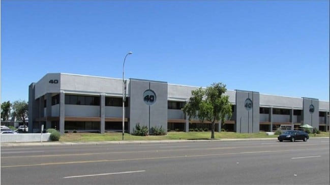
Property Record
40 W Baseline Rd, Tempe, AZ 85283

Current Lease Availabilities
Property Detail
40 W Baseline Rd
Phoenix-Mesa-Chandler, AZ
BASELINE AND MILL MCR 1569-05
133-41-675
MARICOPA
Warehouse
Arizona
2025
2
2025
2.40 AC
319801
Tempe
41,968 SF
Phoenix
NEARBY LISTINGS FOR SALE OR LEASE
DEMOGRAPHICS near 40 W Baseline Rd
1 mile
3 mile
5 mile
2025 Total Population
21,853
141,065
334,737
2030 Population
22,534
145,198
346,320
Pop Growth 2025-2030
+ 3.12%
+ 2.93%
+ 3.46%
Average Age
35
36
37
2025 Total Households
9,425
55,646
137,548
HH Growth 2025-2030
+ 3.24%
+ 3.11%
+ 3.69%
Median Household Inc
$69,584
$82,531
$81,179
Avg Household Size
2.20
2.30
2.30
2025 Avg HH Vehicles
2.00
2.00
2.00
Median Home Value
$382,842
$453,451
$453,176
Median Year Built
1980
1980
1984
Nearby Places
Map Layers
Map Styles
 Street
 Aerial
Transit
 Traffic
 Biking
Places
Listings with unknown addresses are not visible on the map
- Restaurants
- Banks
- Shops
- Fitness
- Groceries
PUBLIC TRANSPORTATION
AIRPORT
Phoenix Sky Harbor International
Drive
Walk
Distance
Phoenix Sky Harbor International
14 min
8.0 mi
Phoenix-Mesa Gateway
Drive
Walk
Distance
Phoenix-Mesa Gateway
32 min
22.0 mi
Nearby Properties
Address
Land Use
TOTAL SIZE
Lot Size
Zoning
Address
Land Use
TOTAL SIZE
Lot Size
Zoning
12.93 AC
I-P
Address
Land Use
TOTAL SIZE
Lot Size
Zoning
2,089,643 SF
33.80 AC
MU-ED
Address
Land Use
TOTAL SIZE
Lot Size
Zoning
1,227,029 SF
7.39 AC
R-6
Address
Land Use
TOTAL SIZE
Lot Size
Zoning
1,056,321 SF
35.93 AC
R1-6
Address
Land Use
TOTAL SIZE
Lot Size
Zoning
5.13 AC
Address
Land Use
TOTAL SIZE
Lot Size
Zoning
1,102,629 SF
12.33 AC
R-3
Address
Land Use
TOTAL SIZE
Lot Size
Zoning
1,479,006 SF
84.96 AC
C-R
Address
Land Use
TOTAL SIZE
Lot Size
Zoning
571,804 SF
0.98 AC
CSS
Address
Land Use
TOTAL SIZE
Lot Size
Zoning
1,020,776 SF
11.33 AC
I-1
Address
Land Use
TOTAL SIZE
Lot Size
Zoning
331,050 SF
39 AC
I-1
Address
Land Use
TOTAL SIZE
Lot Size
Zoning
32,968 SF
2.10 AC
I-P
Address
Land Use
TOTAL SIZE
Lot Size
Zoning
746,457 SF
20.95 AC
I-1
Address
Land Use
TOTAL SIZE
Lot Size
Zoning
352,244 SF
5.55 AC
R-6
Address
Land Use
TOTAL SIZE
Lot Size
Zoning
368,727 SF
12.77 AC
R1-6
Address
Land Use
TOTAL SIZE
Lot Size
Zoning
654,960 SF
19.48 AC
R-6
Address
Land Use
TOTAL SIZE
Lot Size
Zoning
474,335 SF
9.54 AC
R-3
Address
Land Use
TOTAL SIZE
Lot Size
Zoning
683,623 SF
1.80 AC
PAD
Address
Land Use
TOTAL SIZE
Lot Size
Zoning
586,083 SF
69.82 AC
Address
Land Use
TOTAL SIZE
Lot Size
Zoning
378,731 SF
8.68 AC
I-1
Address
Land Use
TOTAL SIZE
Lot Size
Zoning
573,715 SF
3.37 AC
MU4
Address
Land Use
TOTAL SIZE
Lot Size
Zoning
562,356 SF
6.70 AC
MU4
Address
Land Use
TOTAL SIZE
Lot Size
Zoning
256,185 SF
1.89 AC
CSS
Address
Land Use
TOTAL SIZE
Lot Size
Zoning
415,228 SF
19.48 AC
I-1
Address
Land Use
TOTAL SIZE
Lot Size
Zoning
756,193 SF
23.40 AC
I-1
Address
Land Use
TOTAL SIZE
Lot Size
Zoning
249,019 SF
23.96 AC
AG
Address
Land Use
TOTAL SIZE
Lot Size
Zoning
428,895 SF
14.66 AC
PAD
Address
Land Use
TOTAL SIZE
Lot Size
Zoning
317,115 SF
36.47 AC
R-6
Address
Land Use
TOTAL SIZE
Lot Size
Zoning
344,174 SF
4.37 AC
R-4
Address
Land Use
TOTAL SIZE
Lot Size
Zoning
282,793 SF
31.08 AC
R-6
Address
Land Use
TOTAL SIZE
Lot Size
Zoning
355,299 SF
10.01 AC
I-1
The World's #1 Commercial Real Estate Marketplace
Connect with us
© 2026 CoStar Group
The information above has been obtained from sources believed reliable. While we do not doubt its accuracy we have not verified it and make no guarantee, warranty or representation about it. It is your responsibility to independently confirm its accuracy and completeness. Any projections, opinions, assumptions, or estimates used are for example only and do not represent the current or future performance of the property. The value of this transaction to you depends on tax and other factors which should be evaluated by your tax, financial, and legal advisors. You and your advisors should conduct a careful, independent investigation of the property to determine to your satisfaction the suitability of the property for your needs.