Property Record
403 Anderson Ave, Fairview, NJ 07022


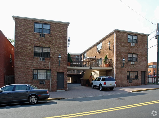

This Property Is For Sale
NEARBY LISTINGS FOR SALE OR LEASE
-
-
-
-
-
-
-
-
-
-
-
-
-
-
-
-
-
-
-
-
-
-
-
-
No Photo
-
-
-
-
-
-
-
View all Fairview listings for sale on LoopNet.com
Property Detail
403 Anderson Ave
New York-Jersey City-White Plains, NY-NJ
Cliffside Park Realty Co Ma
18-00408-0000-00043
75X100
Apartment
Bergen
X
New Jersey
34003C0278H
43
2024
0.17 AC
2025
Bergen County Waterfront
018102
Northern New Jersey
DEMOGRAPHICS near 403 Anderson Ave
1 Mile
3 Mile
5 Mile
2024 Total Population
56,504
664,721
1,931,064
2029 Population
55,945
624,050
1,809,454
Pop Growth 2024-2029
(0.99%)
(6.12%)
(6.30%)
Average Age
41
42
41
2024 Total Households
22,389
282,376
822,870
HH Growth 2024-2029
(0.73%)
(6.37%)
(6.67%)
Median Household Inc
$85,725
$71,289
$69,102
Avg Household Size
2.50
2.20
2.20
2024 Avg HH Vehicles
1.00
1.00
.00
Median Home Value
$593,390
$721,401
$761,470
Median Year Built
1970
1950
1957
Nearby Places
Map Layers
Map Styles
 Street
 Aerial
- Restaurants
- Banks
- Shops
- Fitness
- Groceries
PUBLIC TRANSPORTATION
COMMUTER RAIL
DRIVE
WALK
Distance
12 min
7.0 mi
Melrose Station (Harlem Line - Metro-North Commuter Railroad Company (Metro-North))
DRIVE
WALK
Distance
Melrose Station (Harlem Line - Metro-North Commuter Railroad Company (Metro-North))
16 min
8.8 mi
AIRPORT
Newark Liberty International
DRIVE
WALK
Distance
Newark Liberty International
21 min
15.0 mi
LaGuardia
DRIVE
WALK
Distance
LaGuardia
27 min
15.0 mi
John F Kennedy International
DRIVE
WALK
Distance
John F Kennedy International
38 min
26.1 mi
Freight Ports
NY - Red Hook Container Terminal
DRIVE
WALK
Distance
NY - Red Hook Container Terminal
30 min
15.0 mi
Nearby Properties
Address
Land Use
TOTAL SIZE
Lot Size
Zoning
Address
Land Use
TOTAL SIZE
Lot Size
Zoning
1,233,684 SF
16.94 AC
PARK
Address
Land Use
TOTAL SIZE
Lot Size
Zoning
400,160 SF
10.96 AC
R7-2
Address
Land Use
TOTAL SIZE
Lot Size
Zoning
2,215,000 SF
6.43 AC
R9
Address
Land Use
TOTAL SIZE
Lot Size
Zoning
Address
Land Use
TOTAL SIZE
Lot Size
Zoning
174 AC
P2
Address
Land Use
TOTAL SIZE
Lot Size
Zoning
26.93 AC
R8
Address
Land Use
TOTAL SIZE
Lot Size
Zoning
1,368,870 SF
16.86 AC
R8
Address
Land Use
TOTAL SIZE
Lot Size
Zoning
2,278,432 SF
5.99 AC
R7-2
Address
Land Use
TOTAL SIZE
Lot Size
Zoning
555 SF
4.89 AC
H
Address
Land Use
TOTAL SIZE
Lot Size
Zoning
755,000 SF
1.85 AC
R7-2
Address
Land Use
TOTAL SIZE
Lot Size
Zoning
4,000 SF
57.37 AC
BPC
Address
Land Use
TOTAL SIZE
Lot Size
Zoning
35.58 AC
I
Address
Land Use
TOTAL SIZE
Lot Size
Zoning
4.87 AC
R11
Address
Land Use
TOTAL SIZE
Lot Size
Zoning
873,000 SF
9.95 AC
R7-2
Address
Land Use
TOTAL SIZE
Lot Size
Zoning
0.06 AC
R8
Address
Land Use
TOTAL SIZE
Lot Size
Zoning
1,670,868 SF
9.14 AC
R8
Address
Land Use
TOTAL SIZE
Lot Size
Zoning
7.64 AC
Address
Land Use
TOTAL SIZE
Lot Size
Zoning
Address
Land Use
TOTAL SIZE
Lot Size
Zoning
45.60 AC
Address
Land Use
TOTAL SIZE
Lot Size
Zoning
2.61 AC
D5
Address
Land Use
TOTAL SIZE
Lot Size
Zoning
478,842 SF
3.56 AC
C6-1
Address
Land Use
TOTAL SIZE
Lot Size
Zoning
8.60 AC
P1
Address
Land Use
TOTAL SIZE
Lot Size
Zoning
891,040 SF
5.63 AC
R8
Address
Land Use
TOTAL SIZE
Lot Size
Zoning
0.36 AC
R8
Address
Land Use
TOTAL SIZE
Lot Size
Zoning
4.40 AC
Address
Land Use
TOTAL SIZE
Lot Size
Zoning
3.60 AC
OR1
Address
Land Use
TOTAL SIZE
Lot Size
Zoning
23.12 AC
PARK
Address
Land Use
TOTAL SIZE
Lot Size
Zoning
2,056 SF
0.06 AC
R1
Address
Land Use
TOTAL SIZE
Lot Size
Zoning
698,122 SF
3.47 AC
R8
Address
Land Use
TOTAL SIZE
Lot Size
Zoning
422,000 SF
0.86 AC
R9
The World's #1 Commercial Real Estate Marketplace
Connect with us
© 2025 CoStar Group
The information above has been obtained from sources believed reliable. While we do not doubt its accuracy we have not verified it and make no guarantee, warranty or representation about it. It is your responsibility to independently confirm its accuracy and completeness. Any projections, opinions, assumptions, or estimates used are for example only and do not represent the current or future performance of the property. The value of this transaction to you depends on tax and other factors which should be evaluated by your tax, financial, and legal advisors. You and your advisors should conduct a careful, independent investigation of the property to determine to your satisfaction the suitability of the property for your needs.