Property Record
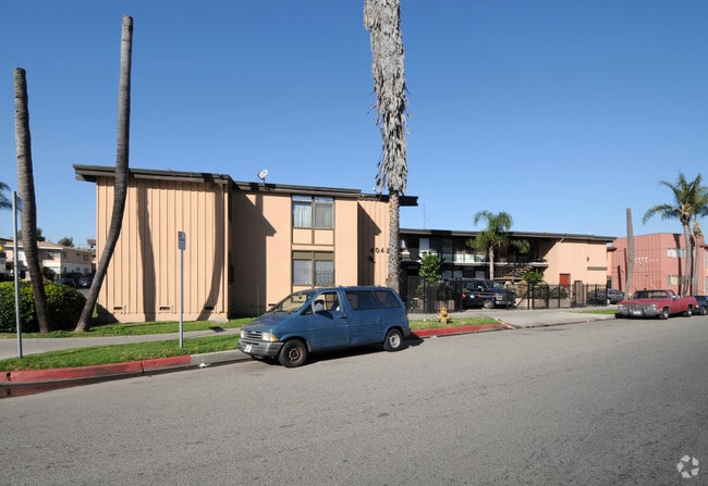
4043 Buckingham Rd, Los Angeles, CA 90008


Save to a Folder
{{folder.Name}}
{{folder.ListingIds.length}} Properties
{{folder.ListingIds.length}} Property
Create a New Folder
Property Detail
4043 Buckingham Rd
5032-008-024
TRACT # 19205 LOT 29
Multifamilydwelling
Los Angeles
LAR3
California
B and X Area of moderate flood hazard, usually the area between the limits of the 100-year and 500-year floods.
29
2025
0.20 AC
2025
Crenshaw
236101
Los Angeles
8,686 SF
Los Angeles-Long Beach-Glendale, CA
NEARBY LISTINGS FOR SALE OR LEASE
DEMOGRAPHICS near 4043 Buckingham Rd
1 mile
3 mile
5 mile
2025 Total Population
37,085
344,294
1,138,042
2030 Population
37,297
342,059
1,133,510
Pop Growth 2025-2030
+ 0.57%
(0.65%)
(0.40%)
Average Age
42
40
39
2025 Total Households
15,540
121,449
422,041
HH Growth 2025-2030
+ 0.26%
(0.88%)
(0.46%)
Median Household Inc
$61,105
$70,646
$73,156
Avg Household Size
2.30
2.70
2.60
2025 Avg HH Vehicles
1.00
2.00
1.00
Median Home Value
$1,038,620
$938,844
$978,741
Median Year Built
1955
1949
1957
Nearby Places
Map Layers
Map Styles
 Street
 Aerial
Layers
 Traffic
 Biking
Places
Listings with unknown addresses are not visible on the map
- Restaurants
- Banks
- Shops
- Fitness
- Groceries
PUBLIC TRANSPORTATION
TRANSIT/SUBWAY
Farmdale (Expo Line - Los Angeles County Metropolitan Transportation Authority (Metro))
Drive
Walk
Distance
Farmdale (Expo Line - Los Angeles County Metropolitan Transportation Authority (Metro))
3 min
18 min
0.9 mi
Expo/Crenshaw (Expo Line - Los Angeles County Metropolitan Transportation Authority (Metro))
Drive
Walk
Distance
Expo/Crenshaw (Expo Line - Los Angeles County Metropolitan Transportation Authority (Metro))
3 min
19 min
1.0 mi
COMMUTER RAIL
Drive
Walk
Distance
16 min
8.5 mi
Union Station (91 Line - Southern California Regional Rail Authority (Metrolink), Antelope Valley Line - Southern California Regional Rail Authority (Metrolink), Orange County Line - Southern California Regional Rail Authority (Metrolink), Riverside Line - Southern California Regional Rail Authority (Metrolink), San Bernardino Line - Southern California Regional Rail Authority (Metrolink), Ventura County Line - Southern California Regional Rail Authority (Metrolink))
Drive
Walk
Distance
Union Station (91 Line - Southern California Regional Rail Authority (Metrolink), Antelope Valley Line - Southern California Regional Rail Authority (Metrolink), Orange County Line - Southern California Regional Rail Authority (Metrolink), Riverside Line - Southern California Regional Rail Authority (Metrolink), San Bernardino Line - Southern California Regional Rail Authority (Metrolink), Ventura County Line - Southern California Regional Rail Authority (Metrolink))
18 min
8.7 mi
AIRPORT
Los Angeles International
Drive
Walk
Distance
Los Angeles International
16 min
7.8 mi
Bob Hope
Drive
Walk
Distance
Bob Hope
33 min
15.3 mi
Long Beach (Daugherty Field)
Drive
Walk
Distance
Long Beach (Daugherty Field)
34 min
24.3 mi
Freight Ports
Port of Los Angeles
Drive
Walk
Distance
Port of Los Angeles
42 min
26.1 mi
Nearby Properties
Address
Land Use
TOTAL SIZE
Lot Size
Zoning
Address
Land Use
TOTAL SIZE
Lot Size
Zoning
597,713 SF
11.18 AC
CCS1YY
Address
Land Use
TOTAL SIZE
Lot Size
Zoning
871,235 SF
14.56 AC
LAC2
Address
Land Use
TOTAL SIZE
Lot Size
Zoning
368,411 SF
10.91 AC
C2-2D-CPIO
Address
Land Use
TOTAL SIZE
Lot Size
Zoning
786,423 SF
11.74 AC
LAC2
Address
Land Use
TOTAL SIZE
Lot Size
Zoning
733,880 SF
3.53 AC
LAMR1
Address
Land Use
TOTAL SIZE
Lot Size
Zoning
274,892 SF
3.53 AC
CCC3EY
Address
Land Use
TOTAL SIZE
Lot Size
Zoning
106,000 SF
4.26 AC
LAMR 1
Address
Land Use
TOTAL SIZE
Lot Size
Zoning
237,673 SF
3.73 AC
M1-2D-CPIO
Address
Land Use
TOTAL SIZE
Lot Size
Zoning
128,347 SF
2.83 AC
LACM
Address
Land Use
TOTAL SIZE
Lot Size
Zoning
73,918 SF
3.86 AC
LAM1
Address
Land Use
TOTAL SIZE
Lot Size
Zoning
175,479 SF
1.63 AC
CCC3VV
Address
Land Use
TOTAL SIZE
Lot Size
Zoning
31,358 SF
5.43 AC
LAMR
Address
Land Use
TOTAL SIZE
Lot Size
Zoning
102,877 SF
8.69 AC
LAC2
Address
Land Use
TOTAL SIZE
Lot Size
Zoning
343,879 SF
4.26 AC
LAC2
Address
Land Use
TOTAL SIZE
Lot Size
Zoning
214,155 SF
3.33 AC
CCM1
Address
Land Use
TOTAL SIZE
Lot Size
Zoning
203,272 SF
14.53 AC
LAC2
Address
Land Use
TOTAL SIZE
Lot Size
Zoning
148,152 SF
3.77 AC
CCM1*
Address
Land Use
TOTAL SIZE
Lot Size
Zoning
66,581 SF
0.60 AC
CCC3YY
Address
Land Use
TOTAL SIZE
Lot Size
Zoning
377,831 SF
8.17 AC
LCC4*
Address
Land Use
TOTAL SIZE
Lot Size
Zoning
376,135 SF
8.02 AC
LCC4*
Address
Land Use
TOTAL SIZE
Lot Size
Zoning
72,641 SF
1.65 AC
CCM1*
Address
Land Use
TOTAL SIZE
Lot Size
Zoning
102,789 SF
0.86 AC
INR3*
Address
Land Use
TOTAL SIZE
Lot Size
Zoning
57,488 SF
4.30 AC
LAPF
Address
Land Use
TOTAL SIZE
Lot Size
Zoning
220,083 SF
4.95 AC
LAR3
Address
Land Use
TOTAL SIZE
Lot Size
Zoning
185,343 SF
1.27 AC
LAC1.5
Address
Land Use
TOTAL SIZE
Lot Size
Zoning
76,895 SF
1.49 AC
CMM1*
Address
Land Use
TOTAL SIZE
Lot Size
Zoning
376,236 SF
1.19 AC
CCR2YY
Address
Land Use
TOTAL SIZE
Lot Size
Zoning
266,457 SF
14.82 AC
LAC1
Address
Land Use
TOTAL SIZE
Lot Size
Zoning
165,898 SF
1.27 AC
CCC3*
Address
Land Use
TOTAL SIZE
Lot Size
Zoning
134,044 SF
1.90 AC
LAC2
The World's #1 Commercial Real Estate Marketplace
Connect with us
© 2026 CoStar Group
The information above has been obtained from sources believed reliable. While we do not doubt its accuracy we have not verified it and make no guarantee, warranty or representation about it. It is your responsibility to independently confirm its accuracy and completeness. Any projections, opinions, assumptions, or estimates used are for example only and do not represent the current or future performance of the property. The value of this transaction to you depends on tax and other factors which should be evaluated by your tax, financial, and legal advisors. You and your advisors should conduct a careful, independent investigation of the property to determine to your satisfaction the suitability of the property for your needs.