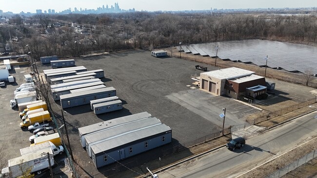
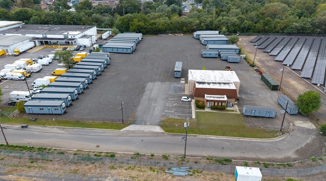
Property Record
405 37Th St, Pennsauken, NJ 08110

Current Lease Availabilities
Property Detail
405 37Th St
Philadelphia-Camden-Wilmington, PA-NJ-DE-MD
Camden
27-00201-0000-00016
New Jersey
Commercialnec
16
AE The base floodplain where base flood elevations are provided. AE Zones are now used on new format FIRMs instead of A1-A30 Zones.
3.18 AC
2025
Camden County
2026
Philadelphia
610500
NEARBY LISTINGS FOR SALE OR LEASE
DEMOGRAPHICS near 405 37Th St
1 mile
3 mile
5 mile
2025 Total Population
14,324
199,723
758,458
2030 Population
14,661
203,196
762,814
Pop Growth 2025-2030
+ 2.35%
+ 1.74%
+ 0.57%
Average Age
37
37
37
2025 Total Households
4,538
74,003
305,574
HH Growth 2025-2030
+ 2.42%
+ 1.65%
+ 0.48%
Median Household Inc
$62,727
$61,367
$65,054
Avg Household Size
3.10
2.60
2.30
2025 Avg HH Vehicles
1.00
1.00
1.00
Median Home Value
$167,143
$234,452
$265,683
Median Year Built
1954
1948
1949
Nearby Places
Map Layers
Map Styles
 Street
 Aerial
Layers
 Traffic
 Biking
Places
Listings with unknown addresses are not visible on the map
- Restaurants
- Banks
- Shops
- Fitness
- Groceries
PUBLIC TRANSPORTATION
TRANSIT/SUBWAY
36th Street (River LINE - River LINE (River LINE))
Drive
Walk
Distance
36th Street (River LINE - River LINE (River LINE))
4 min
16 min
0.8 mi
COMMUTER RAIL
Drive
Walk
Distance
5 min
2.2 mi
Cherry Hill (Atlantic City Line - NJ Transit Commuter Rail (NJ Transit))
Drive
Walk
Distance
Cherry Hill (Atlantic City Line - NJ Transit Commuter Rail (NJ Transit))
12 min
5.7 mi
AIRPORT
Philadelphia International
Drive
Walk
Distance
Philadelphia International
30 min
15.6 mi
Trenton Mercer
Drive
Walk
Distance
Trenton Mercer
51 min
31.3 mi
Freight Ports
South Jersey Port
Drive
Walk
Distance
South Jersey Port
10 min
4.0 mi
Nearby Properties
Address
Land Use
TOTAL SIZE
Lot Size
Zoning
Address
Land Use
TOTAL SIZE
Lot Size
Zoning
880,950 SF
27.71 AC
SPENT
Address
Land Use
TOTAL SIZE
Lot Size
Zoning
1.17 AC
Address
Land Use
TOTAL SIZE
Lot Size
Zoning
7.17 AC
Address
Land Use
TOTAL SIZE
Lot Size
Zoning
804,000 SF
4.29 AC
CMX3
Address
Land Use
TOTAL SIZE
Lot Size
Zoning
12.53 AC
Address
Land Use
TOTAL SIZE
Lot Size
Zoning
322,000 SF
7.44 AC
CMX3
Address
Land Use
TOTAL SIZE
Lot Size
Zoning
348,210 SF
51.22 AC
I3
Address
Land Use
TOTAL SIZE
Lot Size
Zoning
1.62 AC
Address
Land Use
TOTAL SIZE
Lot Size
Zoning
740,701 SF
47.70 AC
I2
Address
Land Use
TOTAL SIZE
Lot Size
Zoning
2.32 AC
Address
Land Use
TOTAL SIZE
Lot Size
Zoning
7.11 AC
Address
Land Use
TOTAL SIZE
Lot Size
Zoning
8.50 AC
Address
Land Use
TOTAL SIZE
Lot Size
Zoning
1.88 AC
Address
Land Use
TOTAL SIZE
Lot Size
Zoning
1.68 AC
Address
Land Use
TOTAL SIZE
Lot Size
Zoning
458,556 SF
1.39 AC
CMX3
Address
Land Use
TOTAL SIZE
Lot Size
Zoning
6.43 AC
Address
Land Use
TOTAL SIZE
Lot Size
Zoning
Address
Land Use
TOTAL SIZE
Lot Size
Zoning
37.60 AC
Address
Land Use
TOTAL SIZE
Lot Size
Zoning
31.99 AC
Address
Land Use
TOTAL SIZE
Lot Size
Zoning
163,400 SF
1.20 AC
CMX3
Address
Land Use
TOTAL SIZE
Lot Size
Zoning
265,000 SF
1.83 AC
CMX3
Address
Land Use
TOTAL SIZE
Lot Size
Zoning
184,842 SF
0.76 AC
CMX3
Address
Land Use
TOTAL SIZE
Lot Size
Zoning
172,844 SF
1.04 AC
CMX2.5
Address
Land Use
TOTAL SIZE
Lot Size
Zoning
17.62 AC
Address
Land Use
TOTAL SIZE
Lot Size
Zoning
Address
Land Use
TOTAL SIZE
Lot Size
Zoning
21.13 AC
Address
Land Use
TOTAL SIZE
Lot Size
Zoning
123,750 SF
0.54 AC
CMX2.5
Address
Land Use
TOTAL SIZE
Lot Size
Zoning
2.09 AC
Address
Land Use
TOTAL SIZE
Lot Size
Zoning
251,657 SF
0.99 AC
ICMX
Address
Land Use
TOTAL SIZE
Lot Size
Zoning
The World's #1 Commercial Real Estate Marketplace
Connect with us
© 2026 CoStar Group
The information above has been obtained from sources believed reliable. While we do not doubt its accuracy we have not verified it and make no guarantee, warranty or representation about it. It is your responsibility to independently confirm its accuracy and completeness. Any projections, opinions, assumptions, or estimates used are for example only and do not represent the current or future performance of the property. The value of this transaction to you depends on tax and other factors which should be evaluated by your tax, financial, and legal advisors. You and your advisors should conduct a careful, independent investigation of the property to determine to your satisfaction the suitability of the property for your needs.