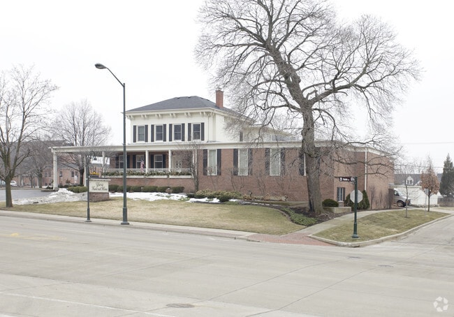
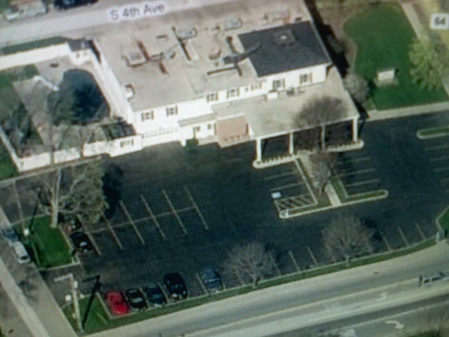
Property Record
405 E Main St, Saint Charles, IL 60174

Property Detail
405 E Main St
Chicago-Naperville-Elgin, IL-IN
MAP AREA: 156-FUNERAL HOME
09-27-465-004
KANE
Commercialnec
Illinois
B and X Area of moderate flood hazard, usually the area between the limits of the 100-year and 500-year floods.
1-8
2024
0.92 AC
2024
Western East/West Corr
852300
Chicago
3,190 SF
NEARBY LISTINGS FOR SALE OR LEASE
DEMOGRAPHICS near 405 E Main St
1 mile
3 mile
5 mile
2025 Total Population
9,976
55,527
104,251
2030 Population
10,059
56,113
105,083
Pop Growth 2025-2030
+ 0.83%
+ 1.06%
+ 0.80%
Average Age
44
42
42
2025 Total Households
4,299
21,567
38,857
HH Growth 2025-2030
+ 0.84%
+ 1.06%
+ 0.81%
Median Household Inc
$97,905
$118,381
$126,438
Avg Household Size
2.30
2.50
2.60
2025 Avg HH Vehicles
2.00
2.00
2.00
Median Home Value
$374,339
$417,040
$429,232
Median Year Built
1975
1984
1987
Nearby Places
Map Layers
Map Styles
 Street
 Aerial
Transit
 Traffic
 Biking
Places
Listings with unknown addresses are not visible on the map
- Restaurants
- Banks
- Shops
- Fitness
- Groceries
PUBLIC TRANSPORTATION
COMMUTER RAIL
Geneva Station (Union Pacific West Line - Northeast Illinois Regional Commuter Railroad (Metra))
Drive
Walk
Distance
Geneva Station (Union Pacific West Line - Northeast Illinois Regional Commuter Railroad (Metra))
7 min
2.9 mi
West Chicago Station (Union Pacific West Line - Northeast Illinois Regional Commuter Railroad (Metra))
Drive
Walk
Distance
West Chicago Station (Union Pacific West Line - Northeast Illinois Regional Commuter Railroad (Metra))
15 min
7.8 mi
AIRPORT
Chicago O'Hare International
Drive
Walk
Distance
Chicago O'Hare International
62 min
27.5 mi
Chicago Midway International
Drive
Walk
Distance
Chicago Midway International
68 min
37.0 mi
Nearby Properties
Address
Land Use
TOTAL SIZE
Lot Size
Zoning
Address
Land Use
TOTAL SIZE
Lot Size
Zoning
404,578 SF
40.29 AC
Address
Land Use
TOTAL SIZE
Lot Size
Zoning
5,482 SF
21.55 AC
Address
Land Use
TOTAL SIZE
Lot Size
Zoning
Address
Land Use
TOTAL SIZE
Lot Size
Zoning
124,474 SF
25.38 AC
Address
Land Use
TOTAL SIZE
Lot Size
Zoning
217,340 SF
15.58 AC
Address
Land Use
TOTAL SIZE
Lot Size
Zoning
Address
Land Use
TOTAL SIZE
Lot Size
Zoning
75.23 AC
Address
Land Use
TOTAL SIZE
Lot Size
Zoning
11.08 AC
Address
Land Use
TOTAL SIZE
Lot Size
Zoning
667,636 SF
38 AC
Address
Land Use
TOTAL SIZE
Lot Size
Zoning
14,138 SF
7.56 AC
Address
Land Use
TOTAL SIZE
Lot Size
Zoning
86,704 SF
0.53 AC
Address
Land Use
TOTAL SIZE
Lot Size
Zoning
306,375 SF
23.82 AC
Address
Land Use
TOTAL SIZE
Lot Size
Zoning
136,208 SF
12.52 AC
Address
Land Use
TOTAL SIZE
Lot Size
Zoning
17.54 AC
Address
Land Use
TOTAL SIZE
Lot Size
Zoning
18.39 AC
Address
Land Use
TOTAL SIZE
Lot Size
Zoning
74,929 SF
6.08 AC
Address
Land Use
TOTAL SIZE
Lot Size
Zoning
Address
Land Use
TOTAL SIZE
Lot Size
Zoning
142,313 SF
15.17 AC
Address
Land Use
TOTAL SIZE
Lot Size
Zoning
4,500 SF
11 AC
Address
Land Use
TOTAL SIZE
Lot Size
Zoning
178,890 SF
34.20 AC
Address
Land Use
TOTAL SIZE
Lot Size
Zoning
14.98 AC
Address
Land Use
TOTAL SIZE
Lot Size
Zoning
36,199 SF
5.84 AC
Address
Land Use
TOTAL SIZE
Lot Size
Zoning
321,702 SF
22.39 AC
Address
Land Use
TOTAL SIZE
Lot Size
Zoning
258,768 SF
28.43 AC
Address
Land Use
TOTAL SIZE
Lot Size
Zoning
Address
Land Use
TOTAL SIZE
Lot Size
Zoning
143,539 SF
19.37 AC
C
Address
Land Use
TOTAL SIZE
Lot Size
Zoning
18,861 SF
135.23 AC
Address
Land Use
TOTAL SIZE
Lot Size
Zoning
3,614 SF
4.46 AC
Address
Land Use
TOTAL SIZE
Lot Size
Zoning
13.46 AC
The World's #1 Commercial Real Estate Marketplace
Connect with us
© 2026 CoStar Group
The information above has been obtained from sources believed reliable. While we do not doubt its accuracy we have not verified it and make no guarantee, warranty or representation about it. It is your responsibility to independently confirm its accuracy and completeness. Any projections, opinions, assumptions, or estimates used are for example only and do not represent the current or future performance of the property. The value of this transaction to you depends on tax and other factors which should be evaluated by your tax, financial, and legal advisors. You and your advisors should conduct a careful, independent investigation of the property to determine to your satisfaction the suitability of the property for your needs.