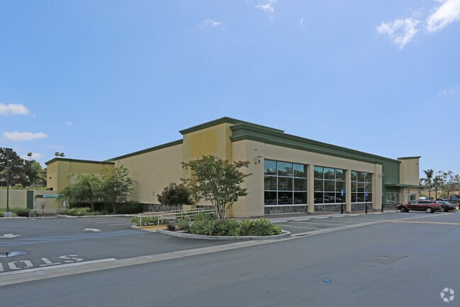
Property Record
4131 Oceanside Blvd, Oceanside, CA 92056


Save to a Folder
{{folder.Name}}
{{folder.ListingIds.length}} Properties
{{folder.ListingIds.length}} Property
Create a New Folder
Property Detail
4131 Oceanside Blvd
162-241-46
PAR 8 PAR A PER DOC09-317328 IN TR PM19519
Supermarket
San Diego
PD-1 (C)
California
AE The base floodplain where base flood elevations are provided. AE Zones are now used on new format FIRMs instead of A1-A30 Zones.
1.29 AC
2025
Oceanside
2026
San Diego
018516
San Diego-Chula Vista-Carlsbad, CA
282 SF
NEARBY LISTINGS FOR SALE OR LEASE
DEMOGRAPHICS near 4131 Oceanside Blvd
1 mile
3 mile
5 mile
2025 Total Population
15,921
146,825
314,333
2030 Population
15,934
147,493
315,549
Pop Growth 2025-2030
+ 0.08%
+ 0.45%
+ 0.39%
Average Age
39
40
40
2025 Total Households
4,882
49,997
109,511
HH Growth 2025-2030
(0.04%)
+ 0.35%
+ 0.30%
Median Household Inc
$103,507
$97,769
$100,992
Avg Household Size
3.10
2.80
2.70
2025 Avg HH Vehicles
2.00
2.00
2.00
Median Home Value
$724,717
$732,879
$791,767
Median Year Built
1981
1984
1983
Nearby Places
Map Layers
Map Styles
 Street
 Aerial
Layers
 Traffic
 Biking
Places
Listings with unknown addresses are not visible on the map
- Restaurants
- Banks
- Shops
- Fitness
- Groceries
PUBLIC TRANSPORTATION
TRANSIT/SUBWAY
College Boulevard (Sprinter - San Diego North County Transit District (Coaster/Sprinter/Breeze))
Drive
Walk
Distance
College Boulevard (Sprinter - San Diego North County Transit District (Coaster/Sprinter/Breeze))
1 min
4 min
0.1 mi
COMMUTER RAIL
Oceanside Transit Center (Orange County Line - Southern California Regional Rail Authority (Metrolink))
Drive
Walk
Distance
Oceanside Transit Center (Orange County Line - Southern California Regional Rail Authority (Metrolink))
13 min
6.5 mi
Carlsbad Village (Coaster - San Diego North County Transit District (Coaster/Sprinter/Breeze))
Drive
Walk
Distance
Carlsbad Village (Coaster - San Diego North County Transit District (Coaster/Sprinter/Breeze))
13 min
7.0 mi
AIRPORT
San Diego International
Drive
Walk
Distance
San Diego International
50 min
39.0 mi
SALE & LEASE HISTORY
LISTING DATE
SALE/LEASE

Sep 25, 2016
For Lease
Nearby Properties
Address
Land Use
TOTAL SIZE
Lot Size
Zoning
Address
Land Use
TOTAL SIZE
Lot Size
Zoning
9,999 SF
20.96 AC
SP-1-84 (I
Address
Land Use
TOTAL SIZE
Lot Size
Zoning
9,999 SF
20.10 AC
M-U
Address
Land Use
TOTAL SIZE
Lot Size
Zoning
9,999 SF
15.25 AC
P-C
Address
Land Use
TOTAL SIZE
Lot Size
Zoning
9,999 SF
11.17 AC
M-U
Address
Land Use
TOTAL SIZE
Lot Size
Zoning
9,999 SF
10.39 AC
M-U (40)
Address
Land Use
TOTAL SIZE
Lot Size
Zoning
9,999 SF
18.89 AC
PD-1 (Res)
Address
Land Use
TOTAL SIZE
Lot Size
Zoning
9,999 SF
12 AC
SP-1-09
Address
Land Use
TOTAL SIZE
Lot Size
Zoning
9,999 SF
15.74 AC
SP-1-84 (I
Address
Land Use
TOTAL SIZE
Lot Size
Zoning
9,999 SF
31.94 AC
RM-B
Address
Land Use
TOTAL SIZE
Lot Size
Zoning
9,999 SF
5.24 AC
SP-1-09
Address
Land Use
TOTAL SIZE
Lot Size
Zoning
9,999 SF
38.61 AC
PD-1 (IL)
Address
Land Use
TOTAL SIZE
Lot Size
Zoning
21.44 AC
C-1
Address
Land Use
TOTAL SIZE
Lot Size
Zoning
9,999 SF
1.23 AC
SPI
Address
Land Use
TOTAL SIZE
Lot Size
Zoning
9,999 SF
7.57 AC
R-M
Address
Land Use
TOTAL SIZE
Lot Size
Zoning
9,999 SF
5.10 AC
R-M
Address
Land Use
TOTAL SIZE
Lot Size
Zoning
9,999 SF
8.01 AC
PD-19-H
Address
Land Use
TOTAL SIZE
Lot Size
Zoning
6,240 SF
22.25 AC
PD-2
Address
Land Use
TOTAL SIZE
Lot Size
Zoning
9,999 SF
9.48 AC
R-M
Address
Land Use
TOTAL SIZE
Lot Size
Zoning
9,999 SF
10.63 AC
RD-M
Address
Land Use
TOTAL SIZE
Lot Size
Zoning
9,999 SF
14.08 AC
RH
Address
Land Use
TOTAL SIZE
Lot Size
Zoning
9,999 SF
10.38 AC
R-M
Address
Land Use
TOTAL SIZE
Lot Size
Zoning
9,999 SF
6.46 AC
CP
Address
Land Use
TOTAL SIZE
Lot Size
Zoning
9,999 SF
6.55 AC
R-M
Address
Land Use
TOTAL SIZE
Lot Size
Zoning
9,999 SF
15.02 AC
SP-1-84 (I
Address
Land Use
TOTAL SIZE
Lot Size
Zoning
9,999 SF
25.16 AC
SP-1-84 (I
Address
Land Use
TOTAL SIZE
Lot Size
Zoning
9,999 SF
11.60 AC
RM-C
Address
Land Use
TOTAL SIZE
Lot Size
Zoning
7,472 SF
4.96 AC
RM-A
Address
Land Use
TOTAL SIZE
Lot Size
Zoning
9,999 SF
6.63 AC
RD-M
Address
Land Use
TOTAL SIZE
Lot Size
Zoning
8,489 SF
2.67 AC
PD-1 (IL)
Address
Land Use
TOTAL SIZE
Lot Size
Zoning
3,995 SF
5.88 AC
PD-1 (IL)
The World's #1 Commercial Real Estate Marketplace
Connect with us
© 2026 CoStar Group
The information above has been obtained from sources believed reliable. While we do not doubt its accuracy we have not verified it and make no guarantee, warranty or representation about it. It is your responsibility to independently confirm its accuracy and completeness. Any projections, opinions, assumptions, or estimates used are for example only and do not represent the current or future performance of the property. The value of this transaction to you depends on tax and other factors which should be evaluated by your tax, financial, and legal advisors. You and your advisors should conduct a careful, independent investigation of the property to determine to your satisfaction the suitability of the property for your needs.