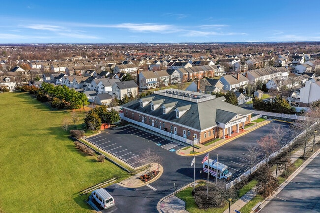
Property Record
42885 Orchard Oriole Dr, Ashburn, VA 20147


Current Lease Availabilities
NEARBY LISTINGS FOR SALE OR LEASE
Property Detail
42885 Orchard Oriole Dr
152-19-9137
Belmont Greene
Publichealthcarefacility
BELMONT GREENE PARCEL F 200710190075229 200711190081284 D/C 200709120066992P
X
Loudoun
51107C0242E
Virginia
2025
1.27 AC
2025
Route 7 Corridor
611004
Washington, DC
10,734 SF
Washington-Arlington-Alexandria, DC-VA-MD-WV
DEMOGRAPHICS near 42885 Orchard Oriole Dr
1 Mile
3 Mile
5 Mile
2024 Total Population
10,353
77,887
177,843
2029 Population
11,130
83,630
192,362
Pop Growth 2024-2029
+ 7.51%
+ 7.37%
+ 8.16%
Average Age
36
38
38
2024 Total Households
3,292
26,300
61,259
HH Growth 2024-2029
+ 7.62%
+ 7.63%
+ 8.41%
Median Household Inc
$173,226
$166,488
$150,414
Avg Household Size
3.10
2.90
2.90
2024 Avg HH Vehicles
2.00
2.00
2.00
Median Home Value
$686,730
$692,801
$684,157
Median Year Built
1999
2000
2002
Nearby Places
Map Layers
Map Styles
 Street
 Aerial
- Restaurants
- Banks
- Shops
- Fitness
- Groceries
PUBLIC TRANSPORTATION
AIRPORT
Washington Dulles International
DRIVE
WALK
Distance
Washington Dulles International
22 min
11.6 mi
Ronald Reagan Washington Ntl
DRIVE
WALK
Distance
Ronald Reagan Washington Ntl
54 min
36.5 mi
Nearby Properties
Address
Land Use
TOTAL SIZE
Lot Size
Zoning
Address
Land Use
TOTAL SIZE
Lot Size
Zoning
793,474 SF
311.38 AC
PDIP
Address
Land Use
TOTAL SIZE
Lot Size
Zoning
250,459 SF
OP
Address
Land Use
TOTAL SIZE
Lot Size
Zoning
1,434,706 SF
30.91 AC
PDRDP
Address
Land Use
TOTAL SIZE
Lot Size
Zoning
356,841 SF
119.07 AC
PDGI
Address
Land Use
TOTAL SIZE
Lot Size
Zoning
684,976 SF
85.31 AC
PDOP
Address
Land Use
TOTAL SIZE
Lot Size
Zoning
431.05 AC
LB:PRC
Address
Land Use
TOTAL SIZE
Lot Size
Zoning
1,070,060 SF
197.44 AC
PDRDP
Address
Land Use
TOTAL SIZE
Lot Size
Zoning
108.01 AC
PDOP
Address
Land Use
TOTAL SIZE
Lot Size
Zoning
341,831 SF
31.21 AC
PDH6
Address
Land Use
TOTAL SIZE
Lot Size
Zoning
553,617 SF
592.60 AC
PDSA
Address
Land Use
TOTAL SIZE
Lot Size
Zoning
340,152 SF
119.26 AC
TR10
Address
Land Use
TOTAL SIZE
Lot Size
Zoning
420,787 SF
LB:B4
Address
Land Use
TOTAL SIZE
Lot Size
Zoning
274,751 SF
18.87 AC
PDH3
Address
Land Use
TOTAL SIZE
Lot Size
Zoning
37.61 AC
IP
Address
Land Use
TOTAL SIZE
Lot Size
Zoning
355,228 SF
35 AC
PDSA
Address
Land Use
TOTAL SIZE
Lot Size
Zoning
198,672 SF
21.41 AC
R16
Address
Land Use
TOTAL SIZE
Lot Size
Zoning
213,071 SF
15.57 AC
PDH3
Address
Land Use
TOTAL SIZE
Lot Size
Zoning
287,479 SF
14.90 AC
PDAAAR
Address
Land Use
TOTAL SIZE
Lot Size
Zoning
199,538 SF
23.35 AC
PDTC
Address
Land Use
TOTAL SIZE
Lot Size
Zoning
61,692 SF
19.86 AC
PDH4
Address
Land Use
TOTAL SIZE
Lot Size
Zoning
218,277 SF
14.54 AC
PDH3
Address
Land Use
TOTAL SIZE
Lot Size
Zoning
260,741 SF
37.30 AC
PDH4
Address
Land Use
TOTAL SIZE
Lot Size
Zoning
165,356 SF
45.07 AC
PDIP
Address
Land Use
TOTAL SIZE
Lot Size
Zoning
198,300 SF
36.09 AC
PDIP
Address
Land Use
TOTAL SIZE
Lot Size
Zoning
413,099 SF
10.12 AC
PDIP
Address
Land Use
TOTAL SIZE
Lot Size
Zoning
261,445 SF
17.95 AC
LB:I1
Address
Land Use
TOTAL SIZE
Lot Size
Zoning
29.72 AC
OP
Address
Land Use
TOTAL SIZE
Lot Size
Zoning
29.66 AC
OP
Address
Land Use
TOTAL SIZE
Lot Size
Zoning
240,844 SF
12.11 AC
PDH4
Address
Land Use
TOTAL SIZE
Lot Size
Zoning
243,052 SF
50.01 AC
PDH3
The World's #1 Commercial Real Estate Marketplace
Connect with us
© 2025 CoStar Group
The information above has been obtained from sources believed reliable. While we do not doubt its accuracy we have not verified it and make no guarantee, warranty or representation about it. It is your responsibility to independently confirm its accuracy and completeness. Any projections, opinions, assumptions, or estimates used are for example only and do not represent the current or future performance of the property. The value of this transaction to you depends on tax and other factors which should be evaluated by your tax, financial, and legal advisors. You and your advisors should conduct a careful, independent investigation of the property to determine to your satisfaction the suitability of the property for your needs.