Property Record
43320 Junction Plz, Ashburn, VA 20147

NEARBY LISTINGS FOR SALE OR LEASE
Property Detail
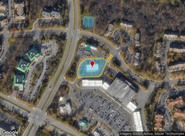
43320 Junction Plz
Washington-Arlington-Alexandria, DC-VA-MD-WV
Ashburn Farm
117-38-3173
ASHBURN FARM SEC.4 BK.6A LOT 1 2399--1812 PC F-407-8
Vehiclerentalsvehiclesales
Loudoun
X
Virginia
51107C0242E
1
2025
1.08 AC
2025
Route 7 Corridor
611005
Washington, DC
6,962 SF
DEMOGRAPHICS near 43320 Junction Plz
1 Mile
3 Mile
5 Mile
2024 Total Population
13,393
91,398
181,345
2029 Population
14,315
98,852
196,199
Pop Growth 2024-2029
+ 6.88%
+ 8.16%
+ 8.19%
Average Age
37
38
38
2024 Total Households
4,389
32,161
62,421
HH Growth 2024-2029
+ 7.02%
+ 8.50%
+ 8.46%
Median Household Inc
$161,816
$160,300
$158,329
Avg Household Size
3.00
2.80
2.90
2024 Avg HH Vehicles
2.00
2.00
2.00
Median Home Value
$649,917
$698,016
$695,247
Median Year Built
1994
2003
2004
Nearby Places
Map Layers
Map Styles
 Street
 Aerial
- Restaurants
- Banks
- Shops
- Fitness
- Groceries
PUBLIC TRANSPORTATION
AIRPORT
Washington Dulles International
DRIVE
WALK
Distance
Washington Dulles International
19 min
9.8 mi
Ronald Reagan Washington Ntl
DRIVE
WALK
Distance
Ronald Reagan Washington Ntl
51 min
34.7 mi
Freight Ports
Port of Baltimore
DRIVE
WALK
Distance
Port of Baltimore
91 min
66.7 mi
Nearby Properties
Address
Land Use
TOTAL SIZE
Lot Size
Zoning
Address
Land Use
TOTAL SIZE
Lot Size
Zoning
2,735,138 SF
123.03 AC
PDAAAR
Address
Land Use
TOTAL SIZE
Lot Size
Zoning
684,976 SF
85.31 AC
PDOP
Address
Land Use
TOTAL SIZE
Lot Size
Zoning
431.05 AC
LB:PRC
Address
Land Use
TOTAL SIZE
Lot Size
Zoning
1,070,060 SF
197.44 AC
PDRDP
Address
Land Use
TOTAL SIZE
Lot Size
Zoning
108.01 AC
PDOP
Address
Land Use
TOTAL SIZE
Lot Size
Zoning
341,831 SF
31.21 AC
PDH6
Address
Land Use
TOTAL SIZE
Lot Size
Zoning
624,852 SF
22.54 AC
R24
Address
Land Use
TOTAL SIZE
Lot Size
Zoning
340,152 SF
119.26 AC
TR10
Address
Land Use
TOTAL SIZE
Lot Size
Zoning
274,751 SF
18.87 AC
PDH3
Address
Land Use
TOTAL SIZE
Lot Size
Zoning
100,121 SF
2.20 AC
PDIP
Address
Land Use
TOTAL SIZE
Lot Size
Zoning
164,455 SF
14.15 AC
PDIP
Address
Land Use
TOTAL SIZE
Lot Size
Zoning
320,609 SF
2.02 AC
PDTRC
Address
Land Use
TOTAL SIZE
Lot Size
Zoning
198,672 SF
21.41 AC
R16
Address
Land Use
TOTAL SIZE
Lot Size
Zoning
213,071 SF
15.57 AC
PDH3
Address
Land Use
TOTAL SIZE
Lot Size
Zoning
287,479 SF
14.90 AC
PDAAAR
Address
Land Use
TOTAL SIZE
Lot Size
Zoning
152,394 SF
10.73 AC
PDIP
Address
Land Use
TOTAL SIZE
Lot Size
Zoning
61,692 SF
19.86 AC
PDH4
Address
Land Use
TOTAL SIZE
Lot Size
Zoning
218,277 SF
14.54 AC
PDH3
Address
Land Use
TOTAL SIZE
Lot Size
Zoning
260,741 SF
37.30 AC
PDH4
Address
Land Use
TOTAL SIZE
Lot Size
Zoning
165,356 SF
45.07 AC
PDIP
Address
Land Use
TOTAL SIZE
Lot Size
Zoning
198,300 SF
36.09 AC
PDIP
Address
Land Use
TOTAL SIZE
Lot Size
Zoning
29.72 AC
OP
Address
Land Use
TOTAL SIZE
Lot Size
Zoning
29.66 AC
OP
Address
Land Use
TOTAL SIZE
Lot Size
Zoning
240,844 SF
12.11 AC
PDH4
Address
Land Use
TOTAL SIZE
Lot Size
Zoning
290,695 SF
3.32 AC
PDOP
Address
Land Use
TOTAL SIZE
Lot Size
Zoning
243,052 SF
50.01 AC
PDH3
Address
Land Use
TOTAL SIZE
Lot Size
Zoning
247,082 SF
57.50 AC
PDH4
Address
Land Use
TOTAL SIZE
Lot Size
Zoning
294,934 SF
7.11 AC
PDIP
Address
Land Use
TOTAL SIZE
Lot Size
Zoning
195,906 SF
25.29 AC
PDIP
Address
Land Use
TOTAL SIZE
Lot Size
Zoning
190,014 SF
22.23 AC
PDCCSC
The World's #1 Commercial Real Estate Marketplace
Connect with us
© 2026 CoStar Group
The information above has been obtained from sources believed reliable. While we do not doubt its accuracy we have not verified it and make no guarantee, warranty or representation about it. It is your responsibility to independently confirm its accuracy and completeness. Any projections, opinions, assumptions, or estimates used are for example only and do not represent the current or future performance of the property. The value of this transaction to you depends on tax and other factors which should be evaluated by your tax, financial, and legal advisors. You and your advisors should conduct a careful, independent investigation of the property to determine to your satisfaction the suitability of the property for your needs.