Property Record
4455 W Colfax Ave, Denver, CO 80204


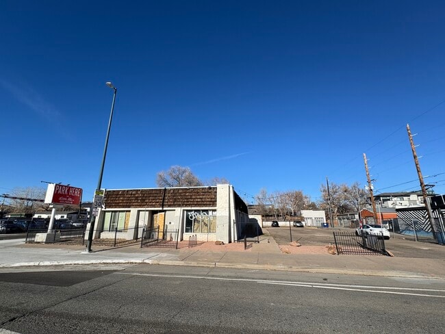

This Property Is For Sale
NEARBY LISTINGS FOR SALE OR LEASE
Property Detail
4455 W Colfax Ave
Denver
Sloan Lake Sub
Denver-Aurora-Lakewood, CO
SLOAN LAKE SUB (AKA SLOANE LAKE SUB BLOCKS 18, 19 & PT 17) B19 L18 TO 23 & VAC 10FT STRIP W COLFAX AVE ADJ L23 EXC E 5FT L 18 TO 22 & N 3FT OF E 5FT W COLFAX AVE VAC BY ORD
2313-11-059
Denver
Officebuilding
Colorado
2024
18-23
2024
0.45 AC
000703
West
3,360 SF
DEMOGRAPHICS near 4455 W Colfax Ave
1 Mile
3 Mile
5 Mile
2024 Total Population
26,833
193,264
473,697
2029 Population
27,665
195,191
477,963
Pop Growth 2024-2029
+ 3.10%
+ 1.00%
+ 0.90%
Average Age
36
38
38
2024 Total Households
11,874
89,401
220,860
HH Growth 2024-2029
+ 3.29%
+ 1.21%
+ 1.02%
Median Household Inc
$69,057
$78,225
$78,781
Avg Household Size
2.10
2.10
2.00
2024 Avg HH Vehicles
1.00
2.00
2.00
Median Home Value
$611,614
$574,290
$550,552
Median Year Built
1970
1970
1967
Nearby Places
Map Layers
Map Styles
 Street
 Aerial
- Restaurants
- Banks
- Shops
- Fitness
- Groceries
PUBLIC TRANSPORTATION
TRANSIT/SUBWAY
Perry (W Line - Denver Regional Transportation District Light Rail (TheRide))
DRIVE
WALK
Distance
Perry (W Line - Denver Regional Transportation District Light Rail (TheRide))
3 min
12 min
0.6 mi
Sheridan (W Line - Denver Regional Transportation District Light Rail (TheRide))
DRIVE
WALK
Distance
Sheridan (W Line - Denver Regional Transportation District Light Rail (TheRide))
2 min
16 min
0.8 mi
Knox (W Line - Denver Regional Transportation District Light Rail (TheRide))
DRIVE
WALK
Distance
Knox (W Line - Denver Regional Transportation District Light Rail (TheRide))
3 min
19 min
0.9 mi
COMMUTER RAIL
Union Station: LoDo-Coors Field-16th Street Mall (C Line - Denver Regional Transportation District Light Rail (TheRide), E Line - Denver Regional Transportation District Light Rail (TheRide), W Line - Denver Regional Transportation District Light Rail (TheRide))
DRIVE
WALK
Distance
Union Station: LoDo-Coors Field-16th Street Mall (C Line - Denver Regional Transportation District Light Rail (TheRide), E Line - Denver Regional Transportation District Light Rail (TheRide), W Line - Denver Regional Transportation District Light Rail (TheRide))
8 min
3.3 mi
DRIVE
WALK
Distance
9 min
3.3 mi
AIRPORT
Denver International
DRIVE
WALK
Distance
Denver International
38 min
27.4 mi
Nearby Properties
Address
Land Use
TOTAL SIZE
Lot Size
Zoning
Address
Land Use
TOTAL SIZE
Lot Size
Zoning
1,882,179 SF
21.15 AC
D-TD
Address
Land Use
TOTAL SIZE
Lot Size
Zoning
1,721,086 SF
21.34 AC
C-MU-30
Address
Land Use
TOTAL SIZE
Lot Size
Zoning
794,383 SF
0.90 AC
D-TD
Address
Land Use
TOTAL SIZE
Lot Size
Zoning
1,542,612 SF
1.56 AC
D-C
Address
Land Use
TOTAL SIZE
Lot Size
Zoning
1,567,575 SF
1.40 AC
D-C
Address
Land Use
TOTAL SIZE
Lot Size
Zoning
1,096,923 SF
16.14 AC
CMP-H
Address
Land Use
TOTAL SIZE
Lot Size
Zoning
1,048,471 SF
2.44 AC
PUD
Address
Land Use
TOTAL SIZE
Lot Size
Zoning
545,292 SF
1.15 AC
D-C
Address
Land Use
TOTAL SIZE
Lot Size
Zoning
614,750 SF
0.23 AC
D-C
Address
Land Use
TOTAL SIZE
Lot Size
Zoning
611,828 SF
0.94 AC
PUD
Address
Land Use
TOTAL SIZE
Lot Size
Zoning
150,202 SF
13.24 AC
T-MU-30
Address
Land Use
TOTAL SIZE
Lot Size
Zoning
337,495 SF
0.57 AC
D-C
Address
Land Use
TOTAL SIZE
Lot Size
Zoning
858,528 SF
2.53 AC
D-C
Address
Land Use
TOTAL SIZE
Lot Size
Zoning
755,793 SF
2.44 AC
D-C
Address
Land Use
TOTAL SIZE
Lot Size
Zoning
677,832 SF
2.42 AC
D-C
Address
Land Use
TOTAL SIZE
Lot Size
Zoning
298,387 SF
0.88 AC
PUD
Address
Land Use
TOTAL SIZE
Lot Size
Zoning
724,981 SF
1.26 AC
D-C
Address
Land Use
TOTAL SIZE
Lot Size
Zoning
405,974 SF
1.78 AC
PUD
Address
Land Use
TOTAL SIZE
Lot Size
Zoning
1,018,386 SF
2.46 AC
D-C
Address
Land Use
TOTAL SIZE
Lot Size
Zoning
290,821 SF
1.16 AC
PUD
Address
Land Use
TOTAL SIZE
Lot Size
Zoning
604,358 SF
2.45 AC
D-C
Address
Land Use
TOTAL SIZE
Lot Size
Zoning
716,151 SF
2.45 AC
D-C
Address
Land Use
TOTAL SIZE
Lot Size
Zoning
618,768 SF
1.23 AC
D-C
Address
Land Use
TOTAL SIZE
Lot Size
Zoning
778,340 SF
0.61 AC
D-C
Address
Land Use
TOTAL SIZE
Lot Size
Zoning
334,746 SF
1.25 AC
D-LD
Address
Land Use
TOTAL SIZE
Lot Size
Zoning
764,724 SF
1 AC
D-C
Address
Land Use
TOTAL SIZE
Lot Size
Zoning
824,150 SF
1.95 AC
D-C
Address
Land Use
TOTAL SIZE
Lot Size
Zoning
1,078,109 SF
36.79 AC
CMP-EI
Address
Land Use
TOTAL SIZE
Lot Size
Zoning
888,385 SF
20.40 AC
I-A
Address
Land Use
TOTAL SIZE
Lot Size
Zoning
497,777 SF
3.70 AC
D-CV
The World's #1 Commercial Real Estate Marketplace
Connect with us
© 2025 CoStar Group
The information above has been obtained from sources believed reliable. While we do not doubt its accuracy we have not verified it and make no guarantee, warranty or representation about it. It is your responsibility to independently confirm its accuracy and completeness. Any projections, opinions, assumptions, or estimates used are for example only and do not represent the current or future performance of the property. The value of this transaction to you depends on tax and other factors which should be evaluated by your tax, financial, and legal advisors. You and your advisors should conduct a careful, independent investigation of the property to determine to your satisfaction the suitability of the property for your needs.