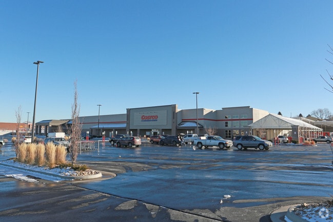
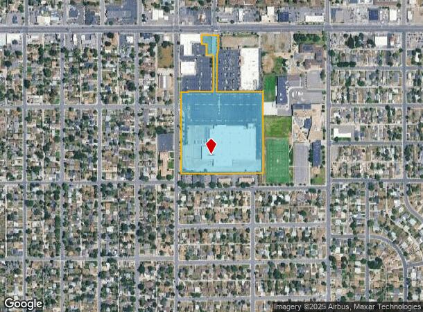
Property Record
400 S Zuni St, Denver, CO 80223

NEARBY LISTINGS FOR SALE OR LEASE
Property Detail
400 S Zuni St
5162-00-041
State Add #2 To Valverde
Storebuilding
STATE ADD #2 TO VALVERDE TR-2 PT COM NW COR S16 3S 68W TH E 30.1FT S 50FT E 182.57FT S 3.5FT TO POB TH E 143.81FT CV/R RAD 30FT DIST 16.47FT DELTA 31.2731 TH S12.4328W 31.78FT S
X
Denver
0800460184J
Colorado
2024
12.42 AC
2024
West
001301
Denver
120,448 SF
Denver-Aurora-Lakewood, CO
DEMOGRAPHICS near 400 S Zuni St
1 Mile
3 Mile
5 Mile
2024 Total Population
16,984
203,333
531,449
2029 Population
16,867
205,766
536,528
Pop Growth 2024-2029
(0.69%)
+ 1.20%
+ 0.96%
Average Age
36
37
38
2024 Total Households
5,586
91,656
250,859
HH Growth 2024-2029
(0.90%)
+ 1.43%
+ 1.09%
Median Household Inc
$52,705
$72,297
$80,377
Avg Household Size
2.90
2.10
2.00
2024 Avg HH Vehicles
2.00
2.00
2.00
Median Home Value
$384,680
$495,224
$608,610
Median Year Built
1954
1960
1968
Nearby Places
- Restaurants
- Banks
- Shops
- Fitness
- Groceries
PUBLIC TRANSPORTATION
AIRPORT
Denver International
DRIVE
WALK
Distance
Denver International
51 min
30.0 mi
Freight Ports
Port of Shreveport
DRIVE
WALK
Distance
Port of Shreveport
1,093 min
987.1 mi
Nearby Properties
Address
Land Use
TOTAL SIZE
Lot Size
Zoning
Address
Land Use
TOTAL SIZE
Lot Size
Zoning
1,882,179 SF
21.15 AC
D-TD
Address
Land Use
TOTAL SIZE
Lot Size
Zoning
1,721,086 SF
21.34 AC
C-MU-30
Address
Land Use
TOTAL SIZE
Lot Size
Zoning
794,383 SF
0.90 AC
D-TD
Address
Land Use
TOTAL SIZE
Lot Size
Zoning
1,542,612 SF
1.56 AC
D-C
Address
Land Use
TOTAL SIZE
Lot Size
Zoning
1,096,923 SF
16.14 AC
CMP-H
Address
Land Use
TOTAL SIZE
Lot Size
Zoning
1,312,939 SF
1.15 AC
D-C
Address
Land Use
TOTAL SIZE
Lot Size
Zoning
1,048,471 SF
2.44 AC
PUD
Address
Land Use
TOTAL SIZE
Lot Size
Zoning
656,257 SF
3.05 AC
D-CV
Address
Land Use
TOTAL SIZE
Lot Size
Zoning
614,750 SF
0.23 AC
D-C
Address
Land Use
TOTAL SIZE
Lot Size
Zoning
337,495 SF
0.57 AC
D-C
Address
Land Use
TOTAL SIZE
Lot Size
Zoning
677,832 SF
2.42 AC
D-C
Address
Land Use
TOTAL SIZE
Lot Size
Zoning
604,358 SF
2.45 AC
D-C
Address
Land Use
TOTAL SIZE
Lot Size
Zoning
778,340 SF
0.61 AC
D-C
Address
Land Use
TOTAL SIZE
Lot Size
Zoning
764,724 SF
1 AC
D-C
Address
Land Use
TOTAL SIZE
Lot Size
Zoning
824,150 SF
1.95 AC
D-C
Address
Land Use
TOTAL SIZE
Lot Size
Zoning
1,078,109 SF
36.79 AC
CMP-EI
Address
Land Use
TOTAL SIZE
Lot Size
Zoning
497,777 SF
3.70 AC
D-CV
Address
Land Use
TOTAL SIZE
Lot Size
Zoning
343,483 SF
5.62 AC
D-TD
Address
Land Use
TOTAL SIZE
Lot Size
Zoning
345,616 SF
3.45 AC
PUD
Address
Land Use
TOTAL SIZE
Lot Size
Zoning
614,122 SF
0.64 AC
D-C
Address
Land Use
TOTAL SIZE
Lot Size
Zoning
572,915 SF
1.52 AC
D-TD
Address
Land Use
TOTAL SIZE
Lot Size
Zoning
666,300 SF
0.79 AC
D-C
Address
Land Use
TOTAL SIZE
Lot Size
Zoning
612,270 SF
0.32 AC
D-C
Address
Land Use
TOTAL SIZE
Lot Size
Zoning
361,069 SF
0.65 AC
D-C
Address
Land Use
TOTAL SIZE
Lot Size
Zoning
488,638 SF
2.44 AC
D-CV
Address
Land Use
TOTAL SIZE
Lot Size
Zoning
729,679 SF
C-MX
Address
Land Use
TOTAL SIZE
Lot Size
Zoning
293,795 SF
5.16 AC
CMP-H
Address
Land Use
TOTAL SIZE
Lot Size
Zoning
835,073 SF
1.41 AC
D-C
Address
Land Use
TOTAL SIZE
Lot Size
Zoning
384,998 SF
2.75 AC
D-TD
Address
Land Use
TOTAL SIZE
Lot Size
Zoning
494,776 SF
3.43 AC
PUD
The World's #1 Commercial Real Estate Marketplace
Connect with us
© 2025 CoStar Group
The information above has been obtained from sources believed reliable. While we do not doubt its accuracy we have not verified it and make no guarantee, warranty or representation about it. It is your responsibility to independently confirm its accuracy and completeness. Any projections, opinions, assumptions, or estimates used are for example only and do not represent the current or future performance of the property. The value of this transaction to you depends on tax and other factors which should be evaluated by your tax, financial, and legal advisors. You and your advisors should conduct a careful, independent investigation of the property to determine to your satisfaction the suitability of the property for your needs.