Property Record
5 E 3Rd St, Keyport, NJ 07735
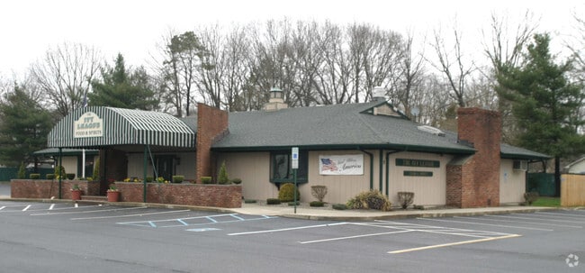

Property Detail
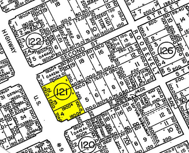
5 E 3Rd St
21-00121-0000-00002
ALSO LOT 4 NIT 1A
Bartavern
Monmouth
HC
New Jersey
B and X Area of moderate flood hazard, usually the area between the limits of the 100-year and 500-year floods.
2
2024
1.38 AC
2025
Western Monmouth
811200
Northern New Jersey
4,578 SF
Lakewood-New Brunswick, NJ
NEARBY LISTINGS FOR SALE OR LEASE
DEMOGRAPHICS near 5 E 3Rd St
1 mile
3 mile
5 mile
2025 Total Population
3,944
41,027
97,665
2030 Population
4,016
40,963
97,512
Pop Growth 2025-2030
+ 1.83%
(0.16%)
(0.16%)
Average Age
42
41
39
2025 Total Households
1,387
13,933
32,220
HH Growth 2025-2030
+ 1.66%
(0.57%)
(0.62%)
Median Household Inc
$76,087
$119,657
$112,083
Avg Household Size
2.70
2.80
2.90
2025 Avg HH Vehicles
2.00
2.00
2.00
Median Home Value
$581,164
$497,383
$500,392
Median Year Built
1990
1982
1983
Nearby Places
Map Layers
Map Styles
 Street
 Aerial
Layers
 Traffic
 Biking
Places
Listings with unknown addresses are not visible on the map
- Restaurants
- Banks
- Shops
- Fitness
- Groceries
PUBLIC TRANSPORTATION
COMMUTER RAIL
Hazlet (North Jersey Coast Line - NJ Transit Commuter Rail (NJ Transit))
Drive
Walk
Distance
Hazlet (North Jersey Coast Line - NJ Transit Commuter Rail (NJ Transit))
5 min
2.1 mi
Aberdeen Matawan (North Jersey Coast Line - NJ Transit Commuter Rail (NJ Transit))
Drive
Walk
Distance
Aberdeen Matawan (North Jersey Coast Line - NJ Transit Commuter Rail (NJ Transit))
5 min
2.5 mi
AIRPORT
Newark Liberty International
Drive
Walk
Distance
Newark Liberty International
40 min
28.2 mi
LaGuardia
Drive
Walk
Distance
LaGuardia
69 min
45.6 mi
John F Kennedy International
Drive
Walk
Distance
John F Kennedy International
71 min
48.7 mi
Freight Ports
New York Container Terminal
Drive
Walk
Distance
New York Container Terminal
33 min
23.3 mi
Nearby Properties
Address
Land Use
TOTAL SIZE
Lot Size
Zoning
Address
Land Use
TOTAL SIZE
Lot Size
Zoning
6,500 SF
48.71 AC
CI
Address
Land Use
TOTAL SIZE
Lot Size
Zoning
Address
Land Use
TOTAL SIZE
Lot Size
Zoning
157,615 SF
17.08 AC
M
Address
Land Use
TOTAL SIZE
Lot Size
Zoning
10.44 AC
TMHO
Address
Land Use
TOTAL SIZE
Lot Size
Zoning
70,624 SF
1.56 AC
MU08
Address
Land Use
TOTAL SIZE
Lot Size
Zoning
29.59 AC
CI
Address
Land Use
TOTAL SIZE
Lot Size
Zoning
2.70 AC
LI
Address
Land Use
TOTAL SIZE
Lot Size
Zoning
192,538 SF
45.11 AC
SF10
Address
Land Use
TOTAL SIZE
Lot Size
Zoning
10.58 AC
APTH
Address
Land Use
TOTAL SIZE
Lot Size
Zoning
151,463 SF
20.58 AC
M-2
Address
Land Use
TOTAL SIZE
Lot Size
Zoning
39,965 SF
17.14 AC
BH
Address
Land Use
TOTAL SIZE
Lot Size
Zoning
4.23 AC
LI
Address
Land Use
TOTAL SIZE
Lot Size
Zoning
186,567 SF
2.31 AC
RC
Address
Land Use
TOTAL SIZE
Lot Size
Zoning
94,150 SF
13.62 AC
M
Address
Land Use
TOTAL SIZE
Lot Size
Zoning
3,641 SF
22.58 AC
C1
Address
Land Use
TOTAL SIZE
Lot Size
Zoning
196,948 SF
19.80 AC
BH
Address
Land Use
TOTAL SIZE
Lot Size
Zoning
42,314 SF
52 AC
IA
Address
Land Use
TOTAL SIZE
Lot Size
Zoning
9.31 AC
APTH
Address
Land Use
TOTAL SIZE
Lot Size
Zoning
81.64 AC
R70
Address
Land Use
TOTAL SIZE
Lot Size
Zoning
420 SF
87.76 AC
OL2
Address
Land Use
TOTAL SIZE
Lot Size
Zoning
9.02 AC
MF0
Address
Land Use
TOTAL SIZE
Lot Size
Zoning
8.62 AC
RC
Address
Land Use
TOTAL SIZE
Lot Size
Zoning
6 AC
RC
Address
Land Use
TOTAL SIZE
Lot Size
Zoning
5 AC
PUD
Address
Land Use
TOTAL SIZE
Lot Size
Zoning
162,250 SF
2.80 AC
RC
Address
Land Use
TOTAL SIZE
Lot Size
Zoning
69,541 SF
2.39 AC
B-2
Address
Land Use
TOTAL SIZE
Lot Size
Zoning
9,904 SF
135.45 AC
M-2
Address
Land Use
TOTAL SIZE
Lot Size
Zoning
28 AC
RO3
Address
Land Use
TOTAL SIZE
Lot Size
Zoning
4,078 SF
15.14 AC
SC2
Address
Land Use
TOTAL SIZE
Lot Size
Zoning
124,651 SF
25.02 AC
CD
The World's #1 Commercial Real Estate Marketplace
Connect with us
© 2026 CoStar Group
The information above has been obtained from sources believed reliable. While we do not doubt its accuracy we have not verified it and make no guarantee, warranty or representation about it. It is your responsibility to independently confirm its accuracy and completeness. Any projections, opinions, assumptions, or estimates used are for example only and do not represent the current or future performance of the property. The value of this transaction to you depends on tax and other factors which should be evaluated by your tax, financial, and legal advisors. You and your advisors should conduct a careful, independent investigation of the property to determine to your satisfaction the suitability of the property for your needs.