Property Record
50 Orange St, Brooklyn, NY 11201
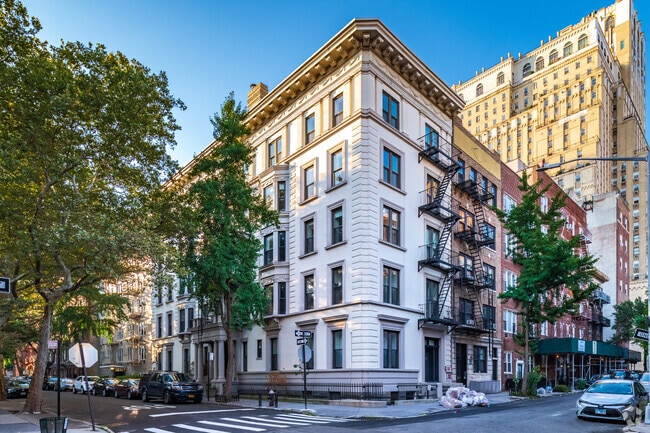

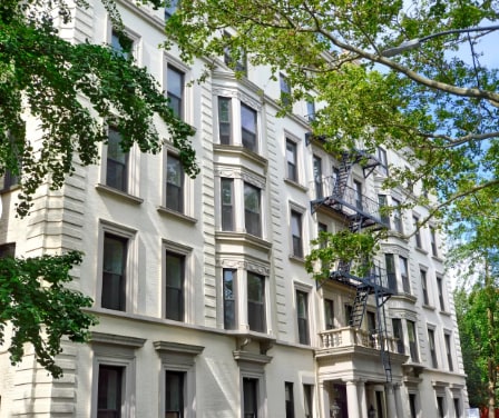

Property Detail
50 Orange St
00226-0008
DOCID-2017120501051001
Multifamilydwelling
KINGS
R7-1
New York
B and X Area of moderate flood hazard, usually the area between the limits of the 100-year and 500-year floods.
8
2025
0.06 AC
2026
Brooklyn Heights
000100
Long Island (New York)
13,500 SF
New York-Jersey City-White Plains, NY-NJ
NEARBY LISTINGS FOR SALE OR LEASE
DEMOGRAPHICS near 50 Orange St
1 mile
3 mile
5 mile
2025 Total Population
139,459
1,133,520
2,823,661
2030 Population
144,907
1,170,358
2,886,246
Pop Growth 2025-2030
+ 3.91%
+ 3.25%
+ 2.22%
Average Age
40
38
39
2025 Total Households
64,591
506,766
1,190,991
HH Growth 2025-2030
+ 3.81%
+ 3.45%
+ 2.68%
Median Household Inc
$132,846
$123,678
$102,395
Avg Household Size
2.00
2.10
2.20
2025 Avg HH Vehicles
.00
.00
.00
Median Home Value
$1,021,391
$1,042,529
$974,388
Median Year Built
1960
1951
1951
Nearby Places
Map Layers
Map Styles
 Street
 Aerial
Layers
 Traffic
 Biking
Places
Listings with unknown addresses are not visible on the map
- Restaurants
- Banks
- Shops
- Fitness
- Groceries
PUBLIC TRANSPORTATION
TRANSIT/SUBWAY
Clark Street (2 - New York MTA Subway (The Subway), 3 - New York MTA Subway (The Subway))
Drive
Walk
Distance
Clark Street (2 - New York MTA Subway (The Subway), 3 - New York MTA Subway (The Subway))
1 min
3 min
0.2 mi
High Street (A - New York MTA Subway (The Subway), C - New York MTA Subway (The Subway))
Drive
Walk
Distance
High Street (A - New York MTA Subway (The Subway), C - New York MTA Subway (The Subway))
1 min
6 min
0.3 mi
York Street (F - New York MTA Subway (The Subway))
Drive
Walk
Distance
York Street (F - New York MTA Subway (The Subway))
3 min
10 min
0.5 mi
Borough Hall-Court Street (2 - New York MTA Subway (The Subway), 3 - New York MTA Subway (The Subway), 4 - New York MTA Subway (The Subway), 5 - New York MTA Subway (The Subway), M - New York MTA Subway (The Subway), N - New York MTA Subway (The Subway), R - New York MTA Subway (The Subway))
Drive
Walk
Distance
Borough Hall-Court Street (2 - New York MTA Subway (The Subway), 3 - New York MTA Subway (The Subway), 4 - New York MTA Subway (The Subway), 5 - New York MTA Subway (The Subway), M - New York MTA Subway (The Subway), N - New York MTA Subway (The Subway), R - New York MTA Subway (The Subway))
3 min
12 min
0.6 mi
Jay Street-Borough Hall (A - New York MTA Subway (The Subway), C - New York MTA Subway (The Subway), F - New York MTA Subway (The Subway))
Drive
Walk
Distance
Jay Street-Borough Hall (A - New York MTA Subway (The Subway), C - New York MTA Subway (The Subway), F - New York MTA Subway (The Subway))
3 min
14 min
0.7 mi
COMMUTER RAIL
Drive
Walk
Distance
7 min
2.2 mi
Christopher St (Hoboken-33rd Street - Port Authority Trans-Hudson (PATH), Journal Square-33rd Street - Port Authority Trans-Hudson (PATH))
Drive
Walk
Distance
Christopher St (Hoboken-33rd Street - Port Authority Trans-Hudson (PATH), Journal Square-33rd Street - Port Authority Trans-Hudson (PATH))
12 min
3.4 mi
AIRPORT
LaGuardia
Drive
Walk
Distance
LaGuardia
19 min
10.1 mi
Newark Liberty International
Drive
Walk
Distance
Newark Liberty International
26 min
14.4 mi
John F Kennedy International
Drive
Walk
Distance
John F Kennedy International
31 min
18.3 mi
Freight Ports
NY - Red Hook Container Terminal
Drive
Walk
Distance
NY - Red Hook Container Terminal
5 min
2.0 mi
SALE & LEASE HISTORY
LISTING DATE
SALE/LEASE

Sep 24, 2016
For Sale
Sep 24, 2016
For Sale
Jun 30, 2017
For Sale
Jun 17, 2024
For Sale
Aug 11, 2017
For Sale
Nearby Properties
Address
Land Use
TOTAL SIZE
Lot Size
Zoning
Address
Land Use
TOTAL SIZE
Lot Size
Zoning
8,462,176 SF
61.41 AC
R7-2
Address
Land Use
TOTAL SIZE
Lot Size
Zoning
940,000 SF
1.44 AC
C6-2
Address
Land Use
TOTAL SIZE
Lot Size
Zoning
2,161,994 SF
3.79 AC
M1-5
Address
Land Use
TOTAL SIZE
Lot Size
Zoning
2,354,289 SF
3.96 AC
C6-4
Address
Land Use
TOTAL SIZE
Lot Size
Zoning
2,812,739 SF
2.10 AC
C5-3
Address
Land Use
TOTAL SIZE
Lot Size
Zoning
2.38 AC
Address
Land Use
TOTAL SIZE
Lot Size
Zoning
2,157,862 SF
2.23 AC
BPC
Address
Land Use
TOTAL SIZE
Lot Size
Zoning
1.75 AC
Address
Land Use
TOTAL SIZE
Lot Size
Zoning
2,255,659 SF
4.58 AC
BPC
Address
Land Use
TOTAL SIZE
Lot Size
Zoning
1,104,184 SF
1.12 AC
C5-5
Address
Land Use
TOTAL SIZE
Lot Size
Zoning
2,124,441 SF
17.29 AC
R8
Address
Land Use
TOTAL SIZE
Lot Size
Zoning
1,233,394 SF
1.78 AC
C5-3
Address
Land Use
TOTAL SIZE
Lot Size
Zoning
1,009,855 SF
3.25 AC
C6-3
Address
Land Use
TOTAL SIZE
Lot Size
Zoning
Address
Land Use
TOTAL SIZE
Lot Size
Zoning
6.42 AC
Address
Land Use
TOTAL SIZE
Lot Size
Zoning
2,233,692 SF
1.90 AC
BPC
Address
Land Use
TOTAL SIZE
Lot Size
Zoning
2.21 AC
Address
Land Use
TOTAL SIZE
Lot Size
Zoning
1,104,505 SF
2.32 AC
C4-7
Address
Land Use
TOTAL SIZE
Lot Size
Zoning
1,560,607 SF
2.69 AC
C6-6
Address
Land Use
TOTAL SIZE
Lot Size
Zoning
1,636,000 SF
1.09 AC
C6-4
Address
Land Use
TOTAL SIZE
Lot Size
Zoning
1,909,502 SF
2.37 AC
BPC
Address
Land Use
TOTAL SIZE
Lot Size
Zoning
7,058,736 SF
147.61 AC
M3-1
Address
Land Use
TOTAL SIZE
Lot Size
Zoning
910,736 SF
1.44 AC
C6-2
Address
Land Use
TOTAL SIZE
Lot Size
Zoning
802,000 SF
1.20 AC
C62A
Address
Land Use
TOTAL SIZE
Lot Size
Zoning
1,780,030 SF
5.07 AC
BPC
Address
Land Use
TOTAL SIZE
Lot Size
Zoning
1,166,710 SF
4.22 AC
C1-7
Address
Land Use
TOTAL SIZE
Lot Size
Zoning
3,122,165 SF
19.02 AC
R7-2
Address
Land Use
TOTAL SIZE
Lot Size
Zoning
1.04 AC
Address
Land Use
TOTAL SIZE
Lot Size
Zoning
1.87 AC
I-2
Address
Land Use
TOTAL SIZE
Lot Size
Zoning
1,617,206 SF
1.23 AC
C5-5
The World's #1 Commercial Real Estate Marketplace
Connect with us
© 2026 CoStar Group
The information above has been obtained from sources believed reliable. While we do not doubt its accuracy we have not verified it and make no guarantee, warranty or representation about it. It is your responsibility to independently confirm its accuracy and completeness. Any projections, opinions, assumptions, or estimates used are for example only and do not represent the current or future performance of the property. The value of this transaction to you depends on tax and other factors which should be evaluated by your tax, financial, and legal advisors. You and your advisors should conduct a careful, independent investigation of the property to determine to your satisfaction the suitability of the property for your needs.