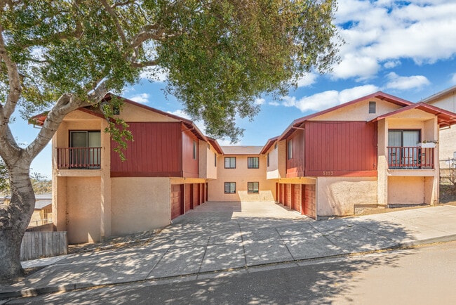
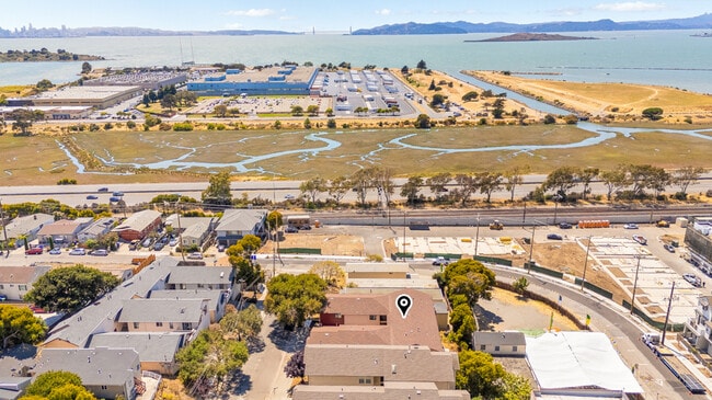
Property Record
5113 Panama Ave, Richmond, CA 94804

Property Detail
5113 Panama Ave
510-092-029-6
RICH ANNEX LOTS 48,49 & 50 BLK 62
Apartment
CONTRA COSTA
MRA
California
B and X Area of moderate flood hazard, usually the area between the limits of the 100-year and 500-year floods.
48
2025
0.17 AC
2025
Southwest Annex
382000
East Bay/Oakland
5,286 SF
Oakland-Fremont-Berkeley, CA
NEARBY LISTINGS FOR SALE OR LEASE
DEMOGRAPHICS near 5113 Panama Ave
1 mile
3 mile
5 mile
2025 Total Population
19,807
138,122
340,447
2030 Population
19,929
138,661
341,821
Pop Growth 2025-2030
+ 0.62%
+ 0.39%
+ 0.40%
Average Age
41
42
39
2025 Total Households
7,903
52,489
124,543
HH Growth 2025-2030
+ 0.61%
+ 0.34%
+ 0.44%
Median Household Inc
$100,635
$119,650
$102,308
Avg Household Size
2.40
2.50
2.50
2025 Avg HH Vehicles
2.00
2.00
2.00
Median Home Value
$819,553
$1,019,648
$941,718
Median Year Built
1961
1953
1956
Nearby Places
Map Layers
Map Styles
 Street
 Aerial
Layers
 Traffic
 Biking
Places
Listings with unknown addresses are not visible on the map
- Restaurants
- Banks
- Shops
- Fitness
- Groceries
PUBLIC TRANSPORTATION
COMMUTER RAIL
Drive
Walk
Distance
6 min
3.3 mi
Drive
Walk
Distance
9 min
4.7 mi
AIRPORT
Metro Oakland International
Drive
Walk
Distance
Metro Oakland International
27 min
18.2 mi
San Francisco International
Drive
Walk
Distance
San Francisco International
39 min
25.8 mi
Freight Ports
Port of Richmond
Drive
Walk
Distance
Port of Richmond
14 min
7.7 mi
SALE & LEASE HISTORY
LISTING DATE
SALE/LEASE

Aug 12, 2025
For Sale
Nearby Properties
Address
Land Use
TOTAL SIZE
Lot Size
Zoning
Address
Land Use
TOTAL SIZE
Lot Size
Zoning
820,000 SF
6.36 AC
Address
Land Use
TOTAL SIZE
Lot Size
Zoning
4.77 AC
Address
Land Use
TOTAL SIZE
Lot Size
Zoning
476,200 SF
22.92 AC
Address
Land Use
TOTAL SIZE
Lot Size
Zoning
254,000 SF
1.71 AC
Address
Land Use
TOTAL SIZE
Lot Size
Zoning
195,281 SF
0.96 AC
Address
Land Use
TOTAL SIZE
Lot Size
Zoning
163,721 SF
0.76 AC
Address
Land Use
TOTAL SIZE
Lot Size
Zoning
3,950 SF
11.47 AC
Address
Land Use
TOTAL SIZE
Lot Size
Zoning
159,705 SF
1.64 AC
COMM
Address
Land Use
TOTAL SIZE
Lot Size
Zoning
105,704 SF
10.85 AC
M3
Address
Land Use
TOTAL SIZE
Lot Size
Zoning
12.31 AC
Address
Land Use
TOTAL SIZE
Lot Size
Zoning
0.61 AC
Address
Land Use
TOTAL SIZE
Lot Size
Zoning
3.61 AC
Address
Land Use
TOTAL SIZE
Lot Size
Zoning
4,550 SF
24.81 AC
Address
Land Use
TOTAL SIZE
Lot Size
Zoning
202,811 SF
10.98 AC
Address
Land Use
TOTAL SIZE
Lot Size
Zoning
191,800 SF
1.09 AC
Address
Land Use
TOTAL SIZE
Lot Size
Zoning
81,149 SF
1.87 AC
Address
Land Use
TOTAL SIZE
Lot Size
Zoning
83,538 SF
0.60 AC
Address
Land Use
TOTAL SIZE
Lot Size
Zoning
124,257 SF
2.72 AC
Address
Land Use
TOTAL SIZE
Lot Size
Zoning
69,949 SF
0.65 AC
C2 CD
Address
Land Use
TOTAL SIZE
Lot Size
Zoning
47,575 SF
1.79 AC
Address
Land Use
TOTAL SIZE
Lot Size
Zoning
182,408 SF
10.55 AC
Address
Land Use
TOTAL SIZE
Lot Size
Zoning
34.95 AC
M3
Address
Land Use
TOTAL SIZE
Lot Size
Zoning
81,352 SF
5.06 AC
C2
Address
Land Use
TOTAL SIZE
Lot Size
Zoning
71,774 SF
12.66 AC
Address
Land Use
TOTAL SIZE
Lot Size
Zoning
96,440 SF
4.73 AC
Address
Land Use
TOTAL SIZE
Lot Size
Zoning
162,660 SF
9.09 AC
Address
Land Use
TOTAL SIZE
Lot Size
Zoning
404,098 SF
24.03 AC
MSL1RD
Address
Land Use
TOTAL SIZE
Lot Size
Zoning
131,400 SF
8.93 AC
M-1
Address
Land Use
TOTAL SIZE
Lot Size
Zoning
54,728 SF
0.96 AC
Address
Land Use
TOTAL SIZE
Lot Size
Zoning
147,500 SF
9.84 AC
The World's #1 Commercial Real Estate Marketplace
Connect with us
© 2026 CoStar Group
The information above has been obtained from sources believed reliable. While we do not doubt its accuracy we have not verified it and make no guarantee, warranty or representation about it. It is your responsibility to independently confirm its accuracy and completeness. Any projections, opinions, assumptions, or estimates used are for example only and do not represent the current or future performance of the property. The value of this transaction to you depends on tax and other factors which should be evaluated by your tax, financial, and legal advisors. You and your advisors should conduct a careful, independent investigation of the property to determine to your satisfaction the suitability of the property for your needs.