Property Record
5125 Sw Hout St, Corvallis, OR 97333


Save to a Folder
{{folder.Name}}
{{folder.ListingIds.length}} Properties
{{folder.ListingIds.length}} Property
Create a New Folder
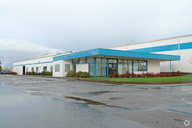
Property Detail
5125 Sw Hout St
Industrialgeneral
Benton
B and X Area of moderate flood hazard, usually the area between the limits of the 100-year and 500-year floods.
Oregon
2025
Oregon West Area
2025
Other Market Areas
010400
Corvallis, OR
55,562 SF
290498
NEARBY LISTINGS FOR SALE OR LEASE
DEMOGRAPHICS near 5125 Sw Hout St
1 mile
3 mile
5 mile
2025 Total Population
233
10,981
53,207
2030 Population
237
11,312
55,867
Pop Growth 2025-2030
+ 1.72%
+ 3.01%
+ 5.00%
Average Age
40
41
35
2025 Total Households
82
4,435
20,723
HH Growth 2025-2030
+ 1.22%
+ 3.04%
+ 5.52%
Median Household Inc
$124,999
$86,000
$58,038
Avg Household Size
2.70
2.40
2.20
2025 Avg HH Vehicles
2.00
2.00
2.00
Median Home Value
$499,999
$475,385
$491,643
Median Year Built
2005
1988
1985
Nearby Places
Map Layers
Map Styles
 Street
 Aerial
Layers
 Traffic
 Biking
Places
Listings with unknown addresses are not visible on the map
- Restaurants
- Banks
- Shops
- Fitness
- Groceries
PUBLIC TRANSPORTATION
AIRPORT
Mahlon Sweet Field
Drive
Walk
Distance
Mahlon Sweet Field
50 min
32.2 mi
Freight Ports
Port of Portland
Drive
Walk
Distance
Port of Portland
117 min
90.4 mi
SALE & LEASE HISTORY
LISTING DATE
SALE/LEASE

Sep 05, 2017
For Sale
Oct 03, 2019
For Sale
Nearby Properties
Address
Land Use
TOTAL SIZE
Lot Size
Zoning
Address
Land Use
TOTAL SIZE
Lot Size
Zoning
159,910 SF
6.22 AC
RS-20
Address
Land Use
TOTAL SIZE
Lot Size
Zoning
139,766 SF
6.41 AC
PD(RS-9)
Address
Land Use
TOTAL SIZE
Lot Size
Zoning
136,117 SF
6.40 AC
PD(RS-9)
Address
Land Use
TOTAL SIZE
Lot Size
Zoning
106,912 SF
4.05 AC
PD(RS-12)
Address
Land Use
TOTAL SIZE
Lot Size
Zoning
76,624 SF
3.40 AC
PD(RS-12)
Address
Land Use
TOTAL SIZE
Lot Size
Zoning
Address
Land Use
TOTAL SIZE
Lot Size
Zoning
178,815 SF
6.63 AC
PD(MUE)
Address
Land Use
TOTAL SIZE
Lot Size
Zoning
70,020 SF
3.21 AC
PD(RS-9)
Address
Land Use
TOTAL SIZE
Lot Size
Zoning
68,704 SF
7.02 AC
RS-12
Address
Land Use
TOTAL SIZE
Lot Size
Zoning
Address
Land Use
TOTAL SIZE
Lot Size
Zoning
Address
Land Use
TOTAL SIZE
Lot Size
Zoning
89,705 SF
9.71 AC
PD(RS-12)
Address
Land Use
TOTAL SIZE
Lot Size
Zoning
60,774 SF
3.60 AC
MUE
Address
Land Use
TOTAL SIZE
Lot Size
Zoning
26,310 SF
4.60 AC
PD(GI)
Address
Land Use
TOTAL SIZE
Lot Size
Zoning
Address
Land Use
TOTAL SIZE
Lot Size
Zoning
39,627 SF
Address
Land Use
TOTAL SIZE
Lot Size
Zoning
36,750 SF
Address
Land Use
TOTAL SIZE
Lot Size
Zoning
60,578 SF
2.24 AC
PD(NC-MINO
Address
Land Use
TOTAL SIZE
Lot Size
Zoning
47,707 SF
2.95 AC
MUE
Address
Land Use
TOTAL SIZE
Lot Size
Zoning
Address
Land Use
TOTAL SIZE
Lot Size
Zoning
42,120 SF
2.08 AC
RS-12
Address
Land Use
TOTAL SIZE
Lot Size
Zoning
Address
Land Use
TOTAL SIZE
Lot Size
Zoning
11,391 SF
0.87 AC
MUCS
Address
Land Use
TOTAL SIZE
Lot Size
Zoning
20,306 SF
2.40 AC
MUE
Address
Land Use
TOTAL SIZE
Lot Size
Zoning
9,970 SF
90.86 AC
AG-OS
Address
Land Use
TOTAL SIZE
Lot Size
Zoning
38,610 SF
4.39 AC
AI
Address
Land Use
TOTAL SIZE
Lot Size
Zoning
13,208 SF
3.54 AC
PD(LI-O)
Address
Land Use
TOTAL SIZE
Lot Size
Zoning
27,420 SF
1.76 AC
RS-12
Address
Land Use
TOTAL SIZE
Lot Size
Zoning
44.75 AC
RS-20
The World's #1 Commercial Real Estate Marketplace
Connect with us
© 2026 CoStar Group
The information above has been obtained from sources believed reliable. While we do not doubt its accuracy we have not verified it and make no guarantee, warranty or representation about it. It is your responsibility to independently confirm its accuracy and completeness. Any projections, opinions, assumptions, or estimates used are for example only and do not represent the current or future performance of the property. The value of this transaction to you depends on tax and other factors which should be evaluated by your tax, financial, and legal advisors. You and your advisors should conduct a careful, independent investigation of the property to determine to your satisfaction the suitability of the property for your needs.