Property Record
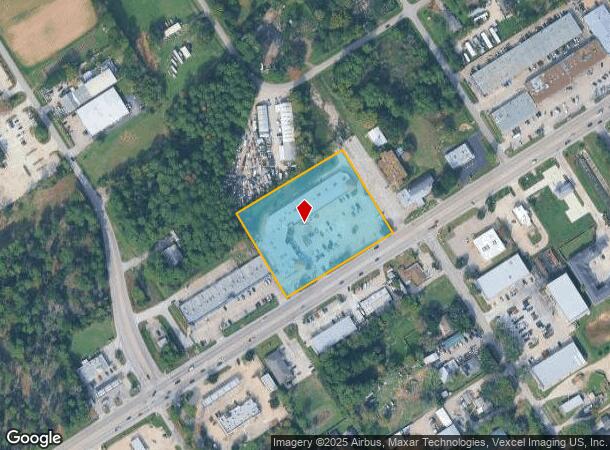
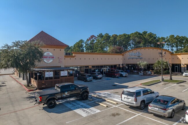
5200 Louetta Rd, Spring, TX 77379

NEARBY LISTINGS FOR SALE OR LEASE
Property Detail
5200 Louetta Rd
1294100010001
Louetta Strack Retail Center
Outdoorrecreationbeachmountaindesert
RES A BLK 1 LOUETTA STRACK RETAIL CENTER
X
Harris
48339C0700F
Texas
2024
3.19 AC
2025
Far North
553801
Houston
32,685 SF
Houston-Pasadena-The Woodlands, TX
DEMOGRAPHICS near 5200 Louetta Rd
1 Mile
3 Mile
5 Mile
2024 Total Population
12,518
97,896
274,598
2029 Population
12,727
99,396
280,503
Pop Growth 2024-2029
+ 1.67%
+ 1.53%
+ 2.15%
Average Age
38
38
37
2024 Total Households
4,151
33,659
96,408
HH Growth 2024-2029
+ 1.73%
+ 1.52%
+ 2.14%
Median Household Inc
$94,009
$89,075
$74,650
Avg Household Size
2.90
2.80
2.80
2024 Avg HH Vehicles
2.00
2.00
2.00
Median Home Value
$265,819
$261,495
$255,163
Median Year Built
1988
1989
1994
Nearby Places
Map Layers
Map Styles
 Street
 Aerial
- Restaurants
- Banks
- Shops
- Fitness
- Groceries
PUBLIC TRANSPORTATION
AIRPORT
George Bush Intcntl/Houston
DRIVE
WALK
Distance
George Bush Intcntl/Houston
25 min
16.0 mi
Freight Ports
Port of Houston
DRIVE
WALK
Distance
Port of Houston
47 min
30.5 mi
SALE & LEASE HISTORY
LISTING DATE
SALE/LEASE

Sep 25, 2016
For Lease
Jan 10, 2018
For Sale
Jan 04, 2018
For Lease
Aug 28, 2017
For Lease
Nearby Properties
Address
Land Use
TOTAL SIZE
Lot Size
Zoning
Address
Land Use
TOTAL SIZE
Lot Size
Zoning
320,507 SF
25.29 AC
Address
Land Use
TOTAL SIZE
Lot Size
Zoning
394,700 SF
17.34 AC
Address
Land Use
TOTAL SIZE
Lot Size
Zoning
180,249 SF
13.35 AC
Address
Land Use
TOTAL SIZE
Lot Size
Zoning
341,336 SF
14.03 AC
Address
Land Use
TOTAL SIZE
Lot Size
Zoning
343,806 SF
17.76 AC
Address
Land Use
TOTAL SIZE
Lot Size
Zoning
434,400 SF
23.55 AC
Address
Land Use
TOTAL SIZE
Lot Size
Zoning
304,096 SF
14.80 AC
Address
Land Use
TOTAL SIZE
Lot Size
Zoning
266,594 SF
10.71 AC
Address
Land Use
TOTAL SIZE
Lot Size
Zoning
286,090 SF
13.25 AC
Address
Land Use
TOTAL SIZE
Lot Size
Zoning
413,131 SF
12.52 AC
Address
Land Use
TOTAL SIZE
Lot Size
Zoning
267,082 SF
11.13 AC
Address
Land Use
TOTAL SIZE
Lot Size
Zoning
148,450 SF
18.26 AC
Address
Land Use
TOTAL SIZE
Lot Size
Zoning
304,518 SF
15 AC
Address
Land Use
TOTAL SIZE
Lot Size
Zoning
297,961 SF
18.04 AC
Address
Land Use
TOTAL SIZE
Lot Size
Zoning
173,371 SF
5.17 AC
Address
Land Use
TOTAL SIZE
Lot Size
Zoning
255,901 SF
11.01 AC
Address
Land Use
TOTAL SIZE
Lot Size
Zoning
114,917 SF
18.61 AC
Address
Land Use
TOTAL SIZE
Lot Size
Zoning
148,506 SF
Address
Land Use
TOTAL SIZE
Lot Size
Zoning
218,967 SF
14.11 AC
Address
Land Use
TOTAL SIZE
Lot Size
Zoning
145,051 SF
6.10 AC
Address
Land Use
TOTAL SIZE
Lot Size
Zoning
214,862 SF
14.92 AC
Address
Land Use
TOTAL SIZE
Lot Size
Zoning
268,232 SF
12.33 AC
Address
Land Use
TOTAL SIZE
Lot Size
Zoning
224,669 SF
15.40 AC
Address
Land Use
TOTAL SIZE
Lot Size
Zoning
256,251 SF
17.72 AC
Address
Land Use
TOTAL SIZE
Lot Size
Zoning
118,475 SF
3.89 AC
Address
Land Use
TOTAL SIZE
Lot Size
Zoning
211,876 SF
21.78 AC
Address
Land Use
TOTAL SIZE
Lot Size
Zoning
202,323 SF
9.37 AC
Address
Land Use
TOTAL SIZE
Lot Size
Zoning
350,072 SF
18.36 AC
Address
Land Use
TOTAL SIZE
Lot Size
Zoning
148,611 SF
5.84 AC
Address
Land Use
TOTAL SIZE
Lot Size
Zoning
223,624 SF
21.91 AC
The World's #1 Commercial Real Estate Marketplace
Connect with us
© 2026 CoStar Group
The information above has been obtained from sources believed reliable. While we do not doubt its accuracy we have not verified it and make no guarantee, warranty or representation about it. It is your responsibility to independently confirm its accuracy and completeness. Any projections, opinions, assumptions, or estimates used are for example only and do not represent the current or future performance of the property. The value of this transaction to you depends on tax and other factors which should be evaluated by your tax, financial, and legal advisors. You and your advisors should conduct a careful, independent investigation of the property to determine to your satisfaction the suitability of the property for your needs.