Property Record
5801 E 76Th Ave, Commerce City, CO 80022
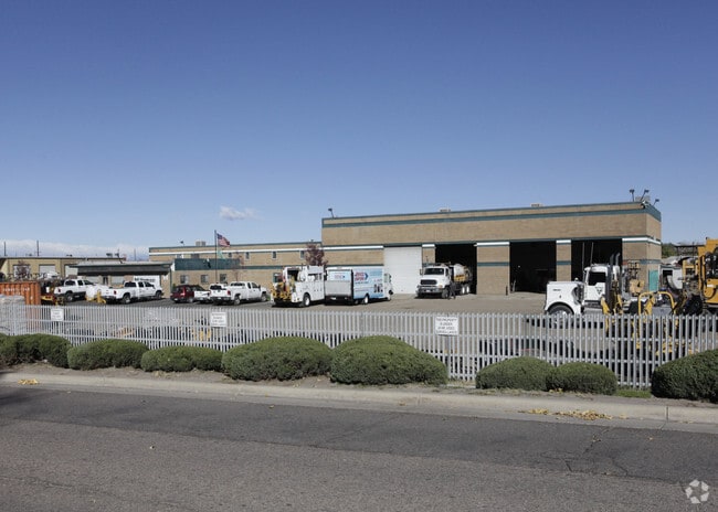


Property Detail
5801 E 76Th Ave
1721-32-2-24-010
SUB:NORWOOD PARK THIRD RESUBD DESC: PT OF BLKS 17 AND 18 AND VAC LARKWOOD ST AND 76TH PL DESC AS FOL BEG AT PT OF INTERSEC OF E LN KENWOOD ST AND S LN 77TH AVE SD PT BEING NW COR OF BLK 22 TH S 369/95 FT TO TRUE POB TH CONT S 227/57 FT TO SW COR BLK
Warehouse
Adams
I2
Colorado
B and X Area of moderate flood hazard, usually the area between the limits of the 100-year and 500-year floods.
2.43 AC
2024
Commerce City
2025
Denver
008802
Denver-Aurora-Centennial, CO
10,809 SF
NEARBY LISTINGS FOR SALE OR LEASE
DEMOGRAPHICS near 5801 E 76Th Ave
1 mile
3 mile
5 mile
2024 Total Population
11,903
55,566
179,935
2029 Population
12,253
57,329
186,294
Pop Growth 2024-2029
+ 2.94%
+ 3.17%
+ 3.53%
Average Age
35
36
36
2024 Total Households
3,403
17,550
60,345
HH Growth 2024-2029
+ 3.11%
+ 3.41%
+ 3.79%
Median Household Inc
$70,568
$76,578
$84,803
Avg Household Size
3.30
3.10
2.90
2024 Avg HH Vehicles
3.00
2.00
2.00
Median Home Value
$348,437
$377,486
$443,945
Median Year Built
1958
1975
1980
Nearby Places
Map Layers
Map Styles
 Street
 Aerial
Transit
 Traffic
 Biking
Places
Listings with unknown addresses are not visible on the map
- Restaurants
- Banks
- Shops
- Fitness
- Groceries
PUBLIC TRANSPORTATION
COMMUTER RAIL
Drive
Walk
Distance
5 min
2.0 mi
Drive
Walk
Distance
9 min
4.6 mi
AIRPORT
Denver International
Drive
Walk
Distance
Denver International
30 min
18.6 mi
Nearby Properties
Address
Land Use
TOTAL SIZE
Lot Size
Zoning
Address
Land Use
TOTAL SIZE
Lot Size
Zoning
396,741 SF
8.12 AC
A1
Address
Land Use
TOTAL SIZE
Lot Size
Zoning
295,558 SF
13.41 AC
Address
Land Use
TOTAL SIZE
Lot Size
Zoning
256,155 SF
3.84 AC
Address
Land Use
TOTAL SIZE
Lot Size
Zoning
106,680 SF
17.39 AC
Address
Land Use
TOTAL SIZE
Lot Size
Zoning
140,328 SF
6.54 AC
PUD
Address
Land Use
TOTAL SIZE
Lot Size
Zoning
17,063 SF
2.01 AC
Address
Land Use
TOTAL SIZE
Lot Size
Zoning
649,540 SF
33.65 AC
Address
Land Use
TOTAL SIZE
Lot Size
Zoning
3,573.99 AC
A3
Address
Land Use
TOTAL SIZE
Lot Size
Zoning
134,729 SF
5.57 AC
Address
Land Use
TOTAL SIZE
Lot Size
Zoning
74,106 SF
3.95 AC
PUD
Address
Land Use
TOTAL SIZE
Lot Size
Zoning
116,502 SF
4.08 AC
Address
Land Use
TOTAL SIZE
Lot Size
Zoning
296,000 SF
52.44 AC
A3
Address
Land Use
TOTAL SIZE
Lot Size
Zoning
549,866 SF
33.82 AC
Address
Land Use
TOTAL SIZE
Lot Size
Zoning
94,213 SF
3.84 AC
A1
Address
Land Use
TOTAL SIZE
Lot Size
Zoning
90,760 SF
6.48 AC
Address
Land Use
TOTAL SIZE
Lot Size
Zoning
85,738 SF
4.43 AC
Address
Land Use
TOTAL SIZE
Lot Size
Zoning
268,268 SF
29.99 AC
I-B
Address
Land Use
TOTAL SIZE
Lot Size
Zoning
616.10 AC
A3
Address
Land Use
TOTAL SIZE
Lot Size
Zoning
328,674 SF
47.13 AC
Address
Land Use
TOTAL SIZE
Lot Size
Zoning
329,940 SF
10.31 AC
Address
Land Use
TOTAL SIZE
Lot Size
Zoning
277,869 SF
12.76 AC
Address
Land Use
TOTAL SIZE
Lot Size
Zoning
11,200 SF
36.45 AC
A1
Address
Land Use
TOTAL SIZE
Lot Size
Zoning
250,523 SF
70.73 AC
I1
Address
Land Use
TOTAL SIZE
Lot Size
Zoning
97,626 SF
14.18 AC
Address
Land Use
TOTAL SIZE
Lot Size
Zoning
99,969 SF
3.46 AC
Address
Land Use
TOTAL SIZE
Lot Size
Zoning
109,372 SF
13.18 AC
Address
Land Use
TOTAL SIZE
Lot Size
Zoning
172,816 SF
59.89 AC
Address
Land Use
TOTAL SIZE
Lot Size
Zoning
459,283 SF
16.88 AC
Address
Land Use
TOTAL SIZE
Lot Size
Zoning
258,279 SF
70.11 AC
I2
Address
Land Use
TOTAL SIZE
Lot Size
Zoning
219,959 SF
10 AC
The World's #1 Commercial Real Estate Marketplace
Connect with us
© 2026 CoStar Group
The information above has been obtained from sources believed reliable. While we do not doubt its accuracy we have not verified it and make no guarantee, warranty or representation about it. It is your responsibility to independently confirm its accuracy and completeness. Any projections, opinions, assumptions, or estimates used are for example only and do not represent the current or future performance of the property. The value of this transaction to you depends on tax and other factors which should be evaluated by your tax, financial, and legal advisors. You and your advisors should conduct a careful, independent investigation of the property to determine to your satisfaction the suitability of the property for your needs.