Property Record
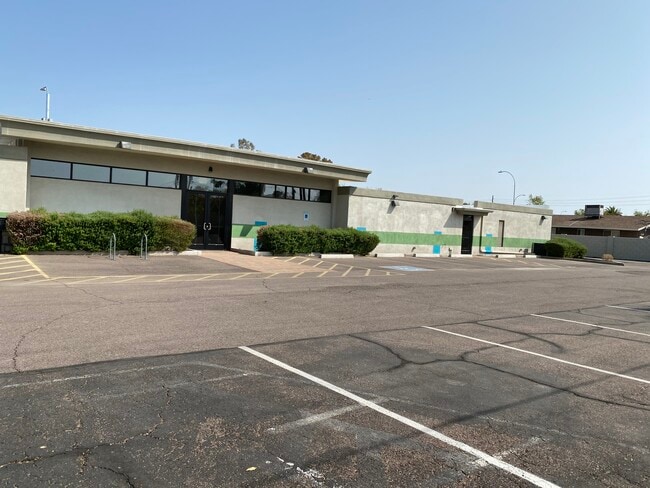
605 E Broadway Rd, Tempe, AZ 85282

Property Detail
605 E Broadway Rd
133-25-070
BROADMOR VISTA MCR 71/09
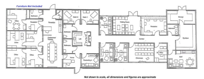
Officebuilding
Maricopa
C-G
Arizona
C and X Area of minimal flood hazard, usually depicted on FIRMs as above the 500-year flood level.
16
2025
0.22 AC
2025
Tempe
319600
Phoenix
4,232 SF
Phoenix-Mesa-Chandler, AZ
NEARBY LISTINGS FOR SALE OR LEASE
DEMOGRAPHICS near 605 E Broadway Rd
1 mile
3 mile
5 mile
2024 Total Population
28,570
155,144
341,556
2029 Population
29,403
161,589
354,405
Pop Growth 2024-2029
+ 2.92%
+ 4.15%
+ 3.76%
Average Age
30
34
36
2024 Total Households
9,974
65,174
142,829
HH Growth 2024-2029
+ 3.50%
+ 4.50%
+ 4.01%
Median Household Inc
$61,745
$69,348
$73,548
Avg Household Size
2.20
2.20
2.20
2024 Avg HH Vehicles
1.00
2.00
2.00
Median Home Value
$598,200
$434,912
$435,691
Median Year Built
1980
1983
1982
Nearby Places
Map Layers
Map Styles
 Street
 Aerial
Transit
 Traffic
 Biking
Places
Listings with unknown addresses are not visible on the map
- Restaurants
- Banks
- Shops
- Fitness
- Groceries
PUBLIC TRANSPORTATION
AIRPORT
Phoenix Sky Harbor International
Drive
Walk
Distance
Phoenix Sky Harbor International
14 min
7.0 mi
Phoenix-Mesa Gateway
Drive
Walk
Distance
Phoenix-Mesa Gateway
33 min
22.5 mi
SALE & LEASE HISTORY
LISTING DATE
SALE/LEASE

Sep 19, 2020
For Lease
Nov 17, 2023
For Sale
Nov 16, 2023
For Lease
Jul 14, 2023
For Lease
Feb 19, 2025
For Sale
Dec 19, 2024
For Sale
Nearby Properties
Address
Land Use
TOTAL SIZE
Lot Size
Zoning
Address
Land Use
TOTAL SIZE
Lot Size
Zoning
4.59 AC
I-1
Address
Land Use
TOTAL SIZE
Lot Size
Zoning
2.63 AC
I-1
Address
Land Use
TOTAL SIZE
Lot Size
Zoning
Address
Land Use
TOTAL SIZE
Lot Size
Zoning
401,544 SF
64.59 AC
GID
Address
Land Use
TOTAL SIZE
Lot Size
Zoning
2,089,643 SF
33.80 AC
MU-ED
Address
Land Use
TOTAL SIZE
Lot Size
Zoning
1,227,029 SF
7.39 AC
R-6
Address
Land Use
TOTAL SIZE
Lot Size
Zoning
106,575 SF
2.50 AC
I-1
Address
Land Use
TOTAL SIZE
Lot Size
Zoning
1,056,321 SF
35.93 AC
R1-6
Address
Land Use
TOTAL SIZE
Lot Size
Zoning
5.13 AC
Address
Land Use
TOTAL SIZE
Lot Size
Zoning
1,102,629 SF
12.33 AC
R-3
Address
Land Use
TOTAL SIZE
Lot Size
Zoning
1,479,006 SF
84.96 AC
C-R
Address
Land Use
TOTAL SIZE
Lot Size
Zoning
2.54 AC
Address
Land Use
TOTAL SIZE
Lot Size
Zoning
571,804 SF
0.98 AC
CSS
Address
Land Use
TOTAL SIZE
Lot Size
Zoning
1,020,776 SF
11.33 AC
I-1
Address
Land Use
TOTAL SIZE
Lot Size
Zoning
331,050 SF
39 AC
I-1
Address
Land Use
TOTAL SIZE
Lot Size
Zoning
58,061 SF
5.43 AC
C-C
Address
Land Use
TOTAL SIZE
Lot Size
Zoning
697,894 SF
8.43 AC
PAD
Address
Land Use
TOTAL SIZE
Lot Size
Zoning
511,014 SF
5.01 AC
I-1
Address
Land Use
TOTAL SIZE
Lot Size
Zoning
548,227 SF
1.62 AC
C-G
Address
Land Use
TOTAL SIZE
Lot Size
Zoning
746,457 SF
20.95 AC
I-1
Address
Land Use
TOTAL SIZE
Lot Size
Zoning
352,244 SF
5.55 AC
R-6
Address
Land Use
TOTAL SIZE
Lot Size
Zoning
368,727 SF
12.77 AC
R1-6
Address
Land Use
TOTAL SIZE
Lot Size
Zoning
654,960 SF
19.48 AC
R-6
Address
Land Use
TOTAL SIZE
Lot Size
Zoning
544,646 SF
1.65 AC
MU4
Address
Land Use
TOTAL SIZE
Lot Size
Zoning
518,223 SF
3.54 AC
C-C
Address
Land Use
TOTAL SIZE
Lot Size
Zoning
401,437 SF
17.70 AC
C-R
The World's #1 Commercial Real Estate Marketplace
Connect with us
© 2026 CoStar Group
The information above has been obtained from sources believed reliable. While we do not doubt its accuracy we have not verified it and make no guarantee, warranty or representation about it. It is your responsibility to independently confirm its accuracy and completeness. Any projections, opinions, assumptions, or estimates used are for example only and do not represent the current or future performance of the property. The value of this transaction to you depends on tax and other factors which should be evaluated by your tax, financial, and legal advisors. You and your advisors should conduct a careful, independent investigation of the property to determine to your satisfaction the suitability of the property for your needs.