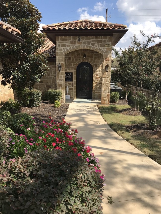
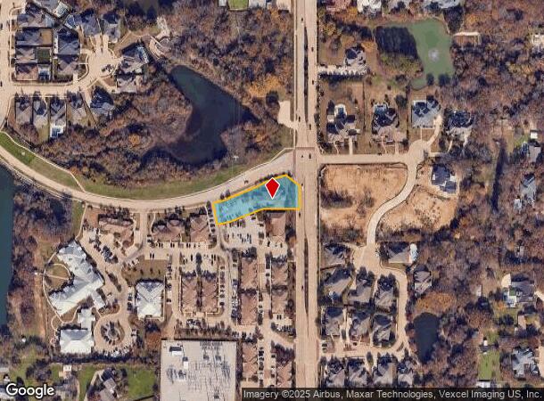
Property Record
630 N Kimball Ave, Southlake, TX 76092

NEARBY LISTINGS FOR SALE OR LEASE
Property Detail
630 N Kimball Ave
Dallas-Fort Worth-Arlington, TX
Silver Ridge Addition
41706323
SILVER RIDGE ADDITION PHASE II LOT 1 PER PLAT D214022161
Commercialnec
Tarrant
X
Texas
48113C0150K
1
2024
0.64 AC
2025
Westlake/Grapevine
113956
Dallas/Ft Worth
5,634 SF
DEMOGRAPHICS near 630 N Kimball Ave
1 Mile
3 Mile
5 Mile
2024 Total Population
4,942
53,807
119,194
2029 Population
5,183
56,490
127,744
Pop Growth 2024-2029
+ 4.88%
+ 4.99%
+ 7.17%
Average Age
41
39
40
2024 Total Households
1,820
19,864
43,265
HH Growth 2024-2029
+ 4.95%
+ 5.06%
+ 7.19%
Median Household Inc
$137,266
$115,850
$143,185
Avg Household Size
2.60
2.70
2.70
2024 Avg HH Vehicles
2.00
2.00
2.00
Median Home Value
$480,341
$559,966
$606,523
Median Year Built
1988
1991
1994
Nearby Places
Map Layers
Map Styles
 Street
 Aerial
- Restaurants
- Banks
- Shops
- Fitness
- Groceries
PUBLIC TRANSPORTATION
AIRPORT
Dallas-Fort Worth International
DRIVE
WALK
Distance
Dallas-Fort Worth International
12 min
8.4 mi
Dallas Love Field
DRIVE
WALK
Distance
Dallas Love Field
30 min
22.1 mi
Freight Ports
Port of Shreveport
DRIVE
WALK
Distance
Port of Shreveport
1 min
207.2 mi
SALE & LEASE HISTORY
LISTING DATE
SALE/LEASE

Oct 03, 2017
For Lease
Aug 02, 2024
For Lease
Nearby Properties
Address
Land Use
TOTAL SIZE
Lot Size
Zoning
Address
Land Use
TOTAL SIZE
Lot Size
Zoning
332,665 SF
9.83 AC
Address
Land Use
TOTAL SIZE
Lot Size
Zoning
397,272 SF
12.35 AC
Address
Land Use
TOTAL SIZE
Lot Size
Zoning
360,898 SF
5.51 AC
Address
Land Use
TOTAL SIZE
Lot Size
Zoning
464,476 SF
5.08 AC
Address
Land Use
TOTAL SIZE
Lot Size
Zoning
321,993 SF
18.20 AC
Address
Land Use
TOTAL SIZE
Lot Size
Zoning
203,458 SF
16.58 AC
Address
Land Use
TOTAL SIZE
Lot Size
Zoning
270,453 SF
17.48 AC
Address
Land Use
TOTAL SIZE
Lot Size
Zoning
235,902 SF
16.20 AC
Address
Land Use
TOTAL SIZE
Lot Size
Zoning
242,000 SF
3.72 AC
Address
Land Use
TOTAL SIZE
Lot Size
Zoning
150,510 SF
6.35 AC
Address
Land Use
TOTAL SIZE
Lot Size
Zoning
261,466 SF
6.83 AC
Address
Land Use
TOTAL SIZE
Lot Size
Zoning
214,908 SF
13.55 AC
Address
Land Use
TOTAL SIZE
Lot Size
Zoning
196,350 SF
12.05 AC
Address
Land Use
TOTAL SIZE
Lot Size
Zoning
177,093 SF
10.79 AC
Address
Land Use
TOTAL SIZE
Lot Size
Zoning
247,505 SF
32 AC
Address
Land Use
TOTAL SIZE
Lot Size
Zoning
306,052 SF
1.92 AC
Address
Land Use
TOTAL SIZE
Lot Size
Zoning
255,288 SF
10.57 AC
Address
Land Use
TOTAL SIZE
Lot Size
Zoning
99,780 SF
0.38 AC
Address
Land Use
TOTAL SIZE
Lot Size
Zoning
191,001 SF
17.58 AC
Address
Land Use
TOTAL SIZE
Lot Size
Zoning
206,950 SF
12.13 AC
Address
Land Use
TOTAL SIZE
Lot Size
Zoning
89,500 SF
8.47 AC
Address
Land Use
TOTAL SIZE
Lot Size
Zoning
136,358 SF
16.51 AC
Address
Land Use
TOTAL SIZE
Lot Size
Zoning
167,847 SF
8.39 AC
Address
Land Use
TOTAL SIZE
Lot Size
Zoning
100.88 AC
Address
Land Use
TOTAL SIZE
Lot Size
Zoning
219,109 SF
24.78 AC
Address
Land Use
TOTAL SIZE
Lot Size
Zoning
195,324 SF
7.48 AC
Address
Land Use
TOTAL SIZE
Lot Size
Zoning
126,875 SF
22.76 AC
Address
Land Use
TOTAL SIZE
Lot Size
Zoning
122,466 SF
43.83 AC
Address
Land Use
TOTAL SIZE
Lot Size
Zoning
174,440 SF
7.02 AC
Address
Land Use
TOTAL SIZE
Lot Size
Zoning
159,092 SF
8.77 AC
The World's #1 Commercial Real Estate Marketplace
Connect with us
© 2025 CoStar Group
The information above has been obtained from sources believed reliable. While we do not doubt its accuracy we have not verified it and make no guarantee, warranty or representation about it. It is your responsibility to independently confirm its accuracy and completeness. Any projections, opinions, assumptions, or estimates used are for example only and do not represent the current or future performance of the property. The value of this transaction to you depends on tax and other factors which should be evaluated by your tax, financial, and legal advisors. You and your advisors should conduct a careful, independent investigation of the property to determine to your satisfaction the suitability of the property for your needs.