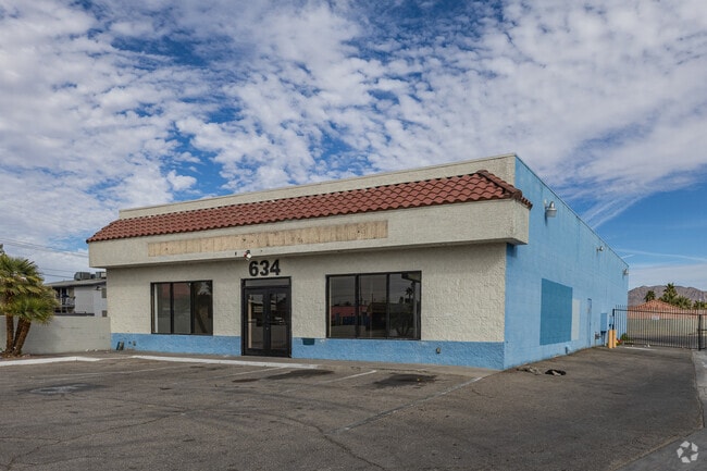
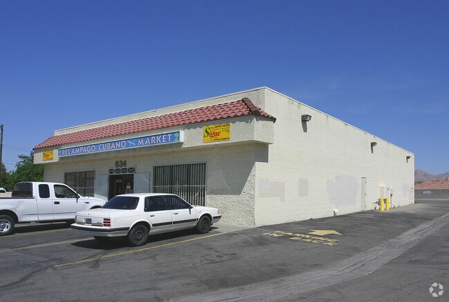
Property Record
634 N Eastern Ave, Las Vegas, NV 89101

Current Lease Availabilities
Property Detail
634 N Eastern Ave
139-25-407-004
PT SW4 SW4 SEC 25 20 61
Storebuilding
Clark
C2
Nevada
B and X Area of moderate flood hazard, usually the area between the limits of the 100-year and 500-year floods.
1.04 AC
2026
Northeast Las Vegas
2026
Las Vegas
000524
Las Vegas-Henderson-North Las Vegas, NV
5,000 SF
NEARBY LISTINGS FOR SALE OR LEASE
DEMOGRAPHICS near 634 N Eastern Ave
1 mile
3 mile
5 mile
2025 Total Population
28,388
232,089
533,081
2030 Population
29,635
242,950
557,487
Pop Growth 2025-2030
+ 4.39%
+ 4.68%
+ 4.58%
Average Age
36
37
38
2025 Total Households
9,620
77,768
187,284
HH Growth 2025-2030
+ 4.48%
+ 4.91%
+ 4.74%
Median Household Inc
$40,107
$45,104
$51,807
Avg Household Size
2.80
2.80
2.70
2025 Avg HH Vehicles
1.00
1.00
2.00
Median Home Value
$272,750
$277,571
$327,361
Median Year Built
1974
1978
1984
Nearby Places
Map Layers
Map Styles
 Street
 Aerial
Layers
 Traffic
 Biking
Places
Listings with unknown addresses are not visible on the map
- Restaurants
- Banks
- Shops
- Fitness
- Groceries
PUBLIC TRANSPORTATION
AIRPORT
Harry Reid International
Drive
Walk
Distance
Harry Reid International
16 min
8.4 mi
Boulder City Municipal
Drive
Walk
Distance
Boulder City Municipal
33 min
25.0 mi
Freight Ports
Port of Long Beach
Drive
Walk
Distance
Port of Long Beach
319 min
286.4 mi
Nearby Properties
Address
Land Use
TOTAL SIZE
Lot Size
Zoning
Address
Land Use
TOTAL SIZE
Lot Size
Zoning
315,865 SF
19.85 AC
Address
Land Use
TOTAL SIZE
Lot Size
Zoning
79,707 SF
2.76 AC
Address
Land Use
TOTAL SIZE
Lot Size
Zoning
39,972 SF
3.04 AC
CV
Address
Land Use
TOTAL SIZE
Lot Size
Zoning
162,214 SF
4.32 AC
Address
Land Use
TOTAL SIZE
Lot Size
Zoning
162,501 SF
5.77 AC
C2
Address
Land Use
TOTAL SIZE
Lot Size
Zoning
18,125 SF
2.14 AC
Address
Land Use
TOTAL SIZE
Lot Size
Zoning
1,617,320 SF
7.21 AC
PD
Address
Land Use
TOTAL SIZE
Lot Size
Zoning
2.79 AC
CV
Address
Land Use
TOTAL SIZE
Lot Size
Zoning
5.96 AC
C2
Address
Land Use
TOTAL SIZE
Lot Size
Zoning
1,283,663 SF
8.56 AC
PD
Address
Land Use
TOTAL SIZE
Lot Size
Zoning
44,418 SF
5.08 AC
PD
Address
Land Use
TOTAL SIZE
Lot Size
Zoning
573,491 SF
38.94 AC
Address
Land Use
TOTAL SIZE
Lot Size
Zoning
814,789 SF
13.75 AC
C1
Address
Land Use
TOTAL SIZE
Lot Size
Zoning
123,990 SF
2.18 AC
C2
Address
Land Use
TOTAL SIZE
Lot Size
Zoning
38.80 AC
CV
Address
Land Use
TOTAL SIZE
Lot Size
Zoning
23,901 SF
5.25 AC
PD
Address
Land Use
TOTAL SIZE
Lot Size
Zoning
324 SF
8.74 AC
R1
Address
Land Use
TOTAL SIZE
Lot Size
Zoning
1,608 SF
30.32 AC
RAPSP
Address
Land Use
TOTAL SIZE
Lot Size
Zoning
8.96 AC
L:PD
Address
Land Use
TOTAL SIZE
Lot Size
Zoning
53,435 SF
2.98 AC
C2
Address
Land Use
TOTAL SIZE
Lot Size
Zoning
16,004 SF
4.19 AC
Address
Land Use
TOTAL SIZE
Lot Size
Zoning
6,396 SF
15.06 AC
Address
Land Use
TOTAL SIZE
Lot Size
Zoning
191,879 SF
12 AC
RACHE
Address
Land Use
TOTAL SIZE
Lot Size
Zoning
198,388 SF
1.88 AC
C2
Address
Land Use
TOTAL SIZE
Lot Size
Zoning
520,114 SF
2.03 AC
Address
Land Use
TOTAL SIZE
Lot Size
Zoning
55,639 SF
6.13 AC
CV
Address
Land Use
TOTAL SIZE
Lot Size
Zoning
103,573 SF
2.75 AC
Address
Land Use
TOTAL SIZE
Lot Size
Zoning
2.84 AC
The World's #1 Commercial Real Estate Marketplace
Connect with us
© 2026 CoStar Group
The information above has been obtained from sources believed reliable. While we do not doubt its accuracy we have not verified it and make no guarantee, warranty or representation about it. It is your responsibility to independently confirm its accuracy and completeness. Any projections, opinions, assumptions, or estimates used are for example only and do not represent the current or future performance of the property. The value of this transaction to you depends on tax and other factors which should be evaluated by your tax, financial, and legal advisors. You and your advisors should conduct a careful, independent investigation of the property to determine to your satisfaction the suitability of the property for your needs.