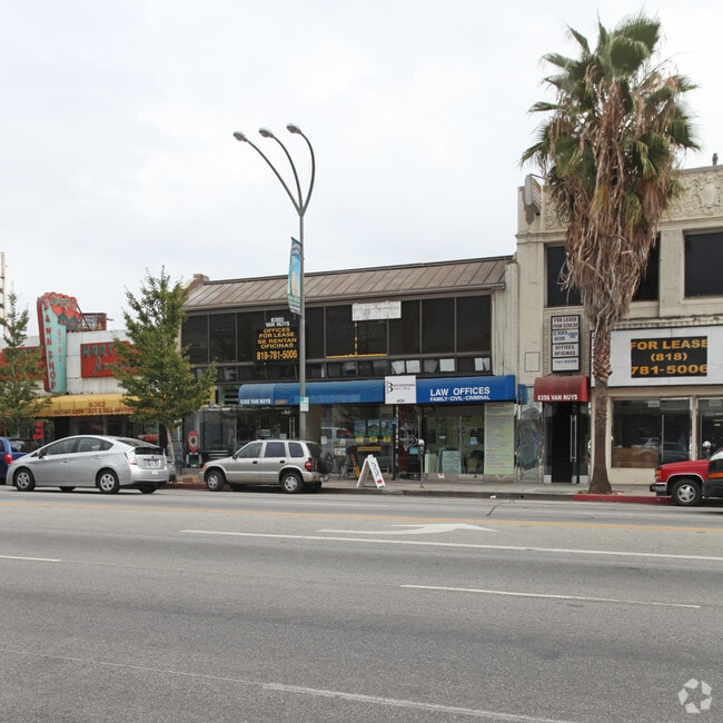
Property Record
6360 Van Nuys Blvd, Van Nuys, CA 91401


Current Lease Availabilities
General Retail LEASE
$22.20 - $140.40 SF/YR
17 - 3,557 SF
Property Detail
6360 Van Nuys Blvd
2240-001-007
TRACT # 1200 LOT 9 AND LOT COM AT SW COR OF LOT 8 BLK 28 TH N 20.66 FT TH E TO E LINE OF SD LOT TH S 20.75 FT TO SE COR OF SD LOT TH W 155 FT TO BEG PART OF LOT 8 BLK 28
Storesoffices
Los Angeles
LAC2
California
B and X Area of moderate flood hazard, usually the area between the limits of the 100-year and 500-year floods.
9,8
2025
0.16 AC
2025
Eastern SFV
128210
Los Angeles
15,824 SF
Los Angeles-Long Beach-Glendale, CA
NEARBY LISTINGS FOR SALE OR LEASE
DEMOGRAPHICS near 6360 Van Nuys Blvd
1 mile
3 mile
5 mile
2025 Total Population
49,360
309,322
713,960
2030 Population
49,240
309,113
712,927
Pop Growth 2025-2030
(0.24%)
(0.07%)
(0.14%)
Average Age
38
39
40
2025 Total Households
16,553
111,644
249,011
HH Growth 2025-2030
(0.40%)
(0.35%)
(0.32%)
Median Household Inc
$67,130
$74,473
$81,398
Avg Household Size
2.80
2.70
2.80
2025 Avg HH Vehicles
2.00
2.00
2.00
Median Home Value
$852,918
$888,379
$869,223
Median Year Built
1972
1969
1968
Nearby Places
Map Layers
Map Styles
 Street
 Aerial
Layers
 Traffic
 Biking
Places
Listings with unknown addresses are not visible on the map
- Restaurants
- Banks
- Shops
- Fitness
- Groceries
PUBLIC TRANSPORTATION
COMMUTER RAIL
Van Nuys (Ventura County Line - Southern California Regional Rail Authority (Metrolink))
Drive
Walk
Distance
Van Nuys (Ventura County Line - Southern California Regional Rail Authority (Metrolink))
4 min
2.2 mi
Sun Valley (Antelope Valley Line - Southern California Regional Rail Authority (Metrolink))
Drive
Walk
Distance
Sun Valley (Antelope Valley Line - Southern California Regional Rail Authority (Metrolink))
12 min
7.2 mi
AIRPORT
Bob Hope
Drive
Walk
Distance
Bob Hope
11 min
6.3 mi
Los Angeles International
Drive
Walk
Distance
Los Angeles International
29 min
20.6 mi
Freight Ports
Port of Long Beach
Drive
Walk
Distance
Port of Long Beach
51 min
39.9 mi
Nearby Properties
Address
Land Use
TOTAL SIZE
Lot Size
Zoning
Address
Land Use
TOTAL SIZE
Lot Size
Zoning
393,032 SF
70.93 AC
LAM2
Address
Land Use
TOTAL SIZE
Lot Size
Zoning
838,226 SF
11.23 AC
LARA
Address
Land Use
TOTAL SIZE
Lot Size
Zoning
1,572,079 SF
11.34 AC
LAC2
Address
Land Use
TOTAL SIZE
Lot Size
Zoning
580,686 SF
8.46 AC
LAR1
Address
Land Use
TOTAL SIZE
Lot Size
Zoning
232,323 SF
4.03 AC
LAC2
Address
Land Use
TOTAL SIZE
Lot Size
Zoning
655,733 SF
1.64 AC
LAC2
Address
Land Use
TOTAL SIZE
Lot Size
Zoning
286,880 SF
2.58 AC
LARAS4
Address
Land Use
TOTAL SIZE
Lot Size
Zoning
415,861 SF
2.79 AC
LAC4
Address
Land Use
TOTAL SIZE
Lot Size
Zoning
72,420 SF
17.08 AC
LAP
Address
Land Use
TOTAL SIZE
Lot Size
Zoning
333,677 SF
3.89 AC
LARAS3
Address
Land Use
TOTAL SIZE
Lot Size
Zoning
271,757 SF
1.97 AC
LAR4
Address
Land Use
TOTAL SIZE
Lot Size
Zoning
204,387 SF
8.46 AC
LAM2
Address
Land Use
TOTAL SIZE
Lot Size
Zoning
619,101 SF
2.81 AC
LAC4
Address
Land Use
TOTAL SIZE
Lot Size
Zoning
268,819 SF
5.22 AC
LAR3
Address
Land Use
TOTAL SIZE
Lot Size
Zoning
396,109 SF
3.45 AC
LAM1
Address
Land Use
TOTAL SIZE
Lot Size
Zoning
68,150 SF
13.88 AC
LARD1.5
Address
Land Use
TOTAL SIZE
Lot Size
Zoning
162,506 SF
2.28 AC
LAC2
Address
Land Use
TOTAL SIZE
Lot Size
Zoning
768,483 SF
6.87 AC
LAC1
Address
Land Use
TOTAL SIZE
Lot Size
Zoning
149,385 SF
1.29 AC
LAR3
Address
Land Use
TOTAL SIZE
Lot Size
Zoning
209,559 SF
4.55 AC
LARD2
Address
Land Use
TOTAL SIZE
Lot Size
Zoning
261,538 SF
1.97 AC
LAP
Address
Land Use
TOTAL SIZE
Lot Size
Zoning
168,271 SF
1.23 AC
LAR4
Address
Land Use
TOTAL SIZE
Lot Size
Zoning
92,730 SF
5.13 AC
LAC2
Address
Land Use
TOTAL SIZE
Lot Size
Zoning
363,090 SF
1.10 AC
LAC4
Address
Land Use
TOTAL SIZE
Lot Size
Zoning
290,244 SF
5.77 AC
LAR3
Address
Land Use
TOTAL SIZE
Lot Size
Zoning
370,138 SF
9.84 AC
LAM2
Address
Land Use
TOTAL SIZE
Lot Size
Zoning
116,961 SF
3.60 AC
LAR3
Address
Land Use
TOTAL SIZE
Lot Size
Zoning
158,644 SF
1.80 AC
LAR3
Address
Land Use
TOTAL SIZE
Lot Size
Zoning
294,426 SF
0.47 AC
LAC2
Address
Land Use
TOTAL SIZE
Lot Size
Zoning
138,260 SF
1.29 AC
LAC2
The World's #1 Commercial Real Estate Marketplace
Connect with us
© 2026 CoStar Group
The information above has been obtained from sources believed reliable. While we do not doubt its accuracy we have not verified it and make no guarantee, warranty or representation about it. It is your responsibility to independently confirm its accuracy and completeness. Any projections, opinions, assumptions, or estimates used are for example only and do not represent the current or future performance of the property. The value of this transaction to you depends on tax and other factors which should be evaluated by your tax, financial, and legal advisors. You and your advisors should conduct a careful, independent investigation of the property to determine to your satisfaction the suitability of the property for your needs.