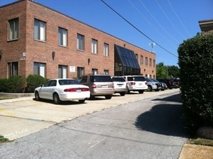
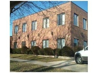
Property Record
6605 N Avondale Ave, Chicago, IL 60631
Current Lease Availabilities
NEARBY LISTINGS FOR SALE OR LEASE
Property Detail
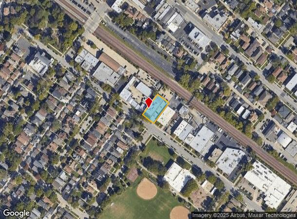
6605 N Avondale Ave
Chicago-Naperville-Elgin, IL-IN-WI
Edison Park In Town Of Maine
09-36-308-014-0000
(EDISON) PARK IN TOWN OF (MAINE) IN SEC 36-41-12
Storebuilding
Cook
X
Illinois
17031C0239J
1,2
2023
0.29 AC
2024
O'Hare
100300
Chicago
13,120 SF
DEMOGRAPHICS near 6605 N Avondale Ave
1 Mile
3 Mile
5 Mile
2024 Total Population
24,194
170,802
493,445
2029 Population
23,392
164,717
475,436
Pop Growth 2024-2029
(3.31%)
(3.56%)
(3.65%)
Average Age
43
43
42
2024 Total Households
9,873
66,150
184,838
HH Growth 2024-2029
(3.56%)
(3.93%)
(3.97%)
Median Household Inc
$106,083
$92,186
$82,354
Avg Household Size
2.40
2.50
2.60
2024 Avg HH Vehicles
2.00
2.00
2.00
Median Home Value
$433,931
$374,987
$345,258
Median Year Built
1953
1958
1957
Nearby Places
Map Layers
Map Styles
 Street
 Aerial
- Restaurants
- Banks
- Shops
- Fitness
- Groceries
PUBLIC TRANSPORTATION
COMMUTER RAIL
Edison Park Station (Union Pacific Northwest Line - Northeast Illinois Regional Commuter Railroad (Metra))
DRIVE
WALK
Distance
Edison Park Station (Union Pacific Northwest Line - Northeast Illinois Regional Commuter Railroad (Metra))
1 min
4 min
0.2 mi
Park Ridge Station (Union Pacific Northwest Line - Northeast Illinois Regional Commuter Railroad (Metra))
DRIVE
WALK
Distance
Park Ridge Station (Union Pacific Northwest Line - Northeast Illinois Regional Commuter Railroad (Metra))
3 min
1.3 mi
AIRPORT
Chicago O'Hare International
DRIVE
WALK
Distance
Chicago O'Hare International
11 min
5.9 mi
Chicago Midway International
DRIVE
WALK
Distance
Chicago Midway International
31 min
17.2 mi
Freight Ports
Port Milwaukee
DRIVE
WALK
Distance
Port Milwaukee
92 min
76.3 mi
Nearby Properties
Address
Land Use
TOTAL SIZE
Lot Size
Zoning
Address
Land Use
TOTAL SIZE
Lot Size
Zoning
1,127,595 SF
Address
Land Use
TOTAL SIZE
Lot Size
Zoning
833,077 SF
11.90 AC
Address
Land Use
TOTAL SIZE
Lot Size
Zoning
203,090 SF
7.96 AC
Address
Land Use
TOTAL SIZE
Lot Size
Zoning
809,460 SF
6.60 AC
PD 258
Address
Land Use
TOTAL SIZE
Lot Size
Zoning
697,000 SF
11.60 AC
PD 71
Address
Land Use
TOTAL SIZE
Lot Size
Zoning
403,200 SF
6.82 AC
PD 193
Address
Land Use
TOTAL SIZE
Lot Size
Zoning
920,000 SF
7.45 AC
PD 193
Address
Land Use
TOTAL SIZE
Lot Size
Zoning
24.49 AC
Address
Land Use
TOTAL SIZE
Lot Size
Zoning
555,681 SF
7.36 AC
PD 340
Address
Land Use
TOTAL SIZE
Lot Size
Zoning
380,895 SF
5.36 AC
Address
Land Use
TOTAL SIZE
Lot Size
Zoning
Address
Land Use
TOTAL SIZE
Lot Size
Zoning
398,424 SF
3.08 AC
PD 71
Address
Land Use
TOTAL SIZE
Lot Size
Zoning
248,726 SF
11.79 AC
PD 44
Address
Land Use
TOTAL SIZE
Lot Size
Zoning
10.24 AC
Address
Land Use
TOTAL SIZE
Lot Size
Zoning
310,145 SF
5.08 AC
PD 71
Address
Land Use
TOTAL SIZE
Lot Size
Zoning
221,692 SF
2.12 AC
Address
Land Use
TOTAL SIZE
Lot Size
Zoning
414,878 SF
20.79 AC
Address
Land Use
TOTAL SIZE
Lot Size
Zoning
246,000 SF
2.29 AC
PD 340
Address
Land Use
TOTAL SIZE
Lot Size
Zoning
334,000 SF
1.77 AC
Address
Land Use
TOTAL SIZE
Lot Size
Zoning
315,373 SF
26.19 AC
Address
Land Use
TOTAL SIZE
Lot Size
Zoning
9.38 AC
PD 1179,PO
Address
Land Use
TOTAL SIZE
Lot Size
Zoning
269,500 SF
11.03 AC
Address
Land Use
TOTAL SIZE
Lot Size
Zoning
286,801 SF
0.94 AC
Address
Land Use
TOTAL SIZE
Lot Size
Zoning
16.27 AC
Address
Land Use
TOTAL SIZE
Lot Size
Zoning
372,935 SF
7.34 AC
Address
Land Use
TOTAL SIZE
Lot Size
Zoning
270,512 SF
2.26 AC
Address
Land Use
TOTAL SIZE
Lot Size
Zoning
322,805 SF
Address
Land Use
TOTAL SIZE
Lot Size
Zoning
1,201,215 SF
8.27 AC
B1-3,RT-4
Address
Land Use
TOTAL SIZE
Lot Size
Zoning
486,884 SF
16.41 AC
Address
Land Use
TOTAL SIZE
Lot Size
Zoning
1.30 AC
The World's #1 Commercial Real Estate Marketplace
Connect with us
© 2025 CoStar Group
The information above has been obtained from sources believed reliable. While we do not doubt its accuracy we have not verified it and make no guarantee, warranty or representation about it. It is your responsibility to independently confirm its accuracy and completeness. Any projections, opinions, assumptions, or estimates used are for example only and do not represent the current or future performance of the property. The value of this transaction to you depends on tax and other factors which should be evaluated by your tax, financial, and legal advisors. You and your advisors should conduct a careful, independent investigation of the property to determine to your satisfaction the suitability of the property for your needs.