Property Record
6712 Fig St, Arvada, CO 80004
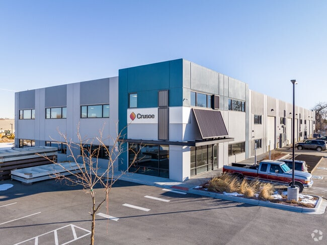

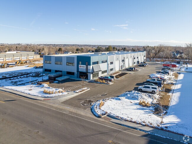
Property Detail
6712 Fig St
Denver-Aurora-Centennial, CO
SECTION 06 TOWNSHIP 03 RANGE 69 QTR SW SUBDIVISIONCD 584600 SUBDIVISIONNAME PARKWAY CENTER BLOCK 004 LOT 0005 SIZE: 84942 TRACT VALUE: 1.950
39-063-01-002
JEFFERSON
Industrialgeneral
Colorado
B and X Area of moderate flood hazard, usually the area between the limits of the 100-year and 500-year floods.
5
2023
1.95 AC
2024
West Denver
010303
Denver
27,000 SF
NEARBY LISTINGS FOR SALE OR LEASE
DEMOGRAPHICS near 6712 Fig St
1 mile
3 mile
5 mile
2025 Total Population
10,807
66,474
161,947
2030 Population
10,687
66,019
160,996
Pop Growth 2025-2030
(1.11%)
(0.68%)
(0.59%)
Average Age
44
43
42
2025 Total Households
4,198
25,667
65,063
HH Growth 2025-2030
(1.29%)
(0.73%)
(0.67%)
Median Household Inc
$129,724
$132,441
$115,195
Avg Household Size
2.50
2.50
2.40
2025 Avg HH Vehicles
2.00
2.00
2.00
Median Home Value
$716,956
$756,793
$714,344
Median Year Built
1986
1987
1978
Nearby Places
Map Layers
Map Styles
 Street
 Aerial
Transit
 Traffic
 Biking
Places
Listings with unknown addresses are not visible on the map
- Restaurants
- Banks
- Shops
- Fitness
- Groceries
PUBLIC TRANSPORTATION
COMMUTER RAIL
Wheat Ridge - Ward Station Track 1 (Union Station to Wheat Ridge Ward Station - Regional Transportation District)
Drive
Walk
Distance
Wheat Ridge - Ward Station Track 1 (Union Station to Wheat Ridge Ward Station - Regional Transportation District)
8 min
3.5 mi
Arvada Ridge Station Track 1 (Union Station to Wheat Ridge Ward Station - Regional Transportation District)
Drive
Walk
Distance
Arvada Ridge Station Track 1 (Union Station to Wheat Ridge Ward Station - Regional Transportation District)
8 min
4.3 mi
AIRPORT
Denver International
Drive
Walk
Distance
Denver International
45 min
33.7 mi
Freight Ports
Tulsa Port Of Catoosa
Drive
Walk
Distance
Tulsa Port Of Catoosa
742 min
719.2 mi
Nearby Properties
Address
Land Use
TOTAL SIZE
Lot Size
Zoning
Address
Land Use
TOTAL SIZE
Lot Size
Zoning
269,013 SF
31.89 AC
Address
Land Use
TOTAL SIZE
Lot Size
Zoning
253,643 SF
50.87 AC
A2
Address
Land Use
TOTAL SIZE
Lot Size
Zoning
227,132 SF
11.95 AC
Address
Land Use
TOTAL SIZE
Lot Size
Zoning
389,561 SF
10.73 AC
Address
Land Use
TOTAL SIZE
Lot Size
Zoning
215,878 SF
11.82 AC
A2
Address
Land Use
TOTAL SIZE
Lot Size
Zoning
131,135 SF
2.83 AC
Address
Land Use
TOTAL SIZE
Lot Size
Zoning
262,699 SF
13.10 AC
A2
Address
Land Use
TOTAL SIZE
Lot Size
Zoning
363,989 SF
30.10 AC
Address
Land Use
TOTAL SIZE
Lot Size
Zoning
101,761 SF
4.34 AC
Address
Land Use
TOTAL SIZE
Lot Size
Zoning
142,200 SF
9.82 AC
Address
Land Use
TOTAL SIZE
Lot Size
Zoning
520,896 SF
24.42 AC
I1
Address
Land Use
TOTAL SIZE
Lot Size
Zoning
223,338 SF
9.42 AC
I1
Address
Land Use
TOTAL SIZE
Lot Size
Zoning
64,883 SF
4.74 AC
Address
Land Use
TOTAL SIZE
Lot Size
Zoning
82,055 SF
19.39 AC
Address
Land Use
TOTAL SIZE
Lot Size
Zoning
68,300 SF
6 AC
Address
Land Use
TOTAL SIZE
Lot Size
Zoning
67,520 SF
6.46 AC
Address
Land Use
TOTAL SIZE
Lot Size
Zoning
51,987 SF
15.23 AC
PD
Address
Land Use
TOTAL SIZE
Lot Size
Zoning
83,684 SF
8.15 AC
Address
Land Use
TOTAL SIZE
Lot Size
Zoning
50,852 SF
3.94 AC
Address
Land Use
TOTAL SIZE
Lot Size
Zoning
201,582 SF
5.78 AC
Address
Land Use
TOTAL SIZE
Lot Size
Zoning
123,448 SF
7.80 AC
Address
Land Use
TOTAL SIZE
Lot Size
Zoning
67,879 SF
9.91 AC
A2
Address
Land Use
TOTAL SIZE
Lot Size
Zoning
437,083 SF
27.42 AC
Address
Land Use
TOTAL SIZE
Lot Size
Zoning
68,500 SF
5.84 AC
Address
Land Use
TOTAL SIZE
Lot Size
Zoning
54,236 SF
8.72 AC
Address
Land Use
TOTAL SIZE
Lot Size
Zoning
113,455 SF
7.98 AC
Address
Land Use
TOTAL SIZE
Lot Size
Zoning
175,599 SF
17.23 AC
Address
Land Use
TOTAL SIZE
Lot Size
Zoning
110,235 SF
2.32 AC
Address
Land Use
TOTAL SIZE
Lot Size
Zoning
62,604 SF
75.98 AC
Address
Land Use
TOTAL SIZE
Lot Size
Zoning
188,494 SF
15.14 AC
The World's #1 Commercial Real Estate Marketplace
Connect with us
© 2026 CoStar Group
The information above has been obtained from sources believed reliable. While we do not doubt its accuracy we have not verified it and make no guarantee, warranty or representation about it. It is your responsibility to independently confirm its accuracy and completeness. Any projections, opinions, assumptions, or estimates used are for example only and do not represent the current or future performance of the property. The value of this transaction to you depends on tax and other factors which should be evaluated by your tax, financial, and legal advisors. You and your advisors should conduct a careful, independent investigation of the property to determine to your satisfaction the suitability of the property for your needs.