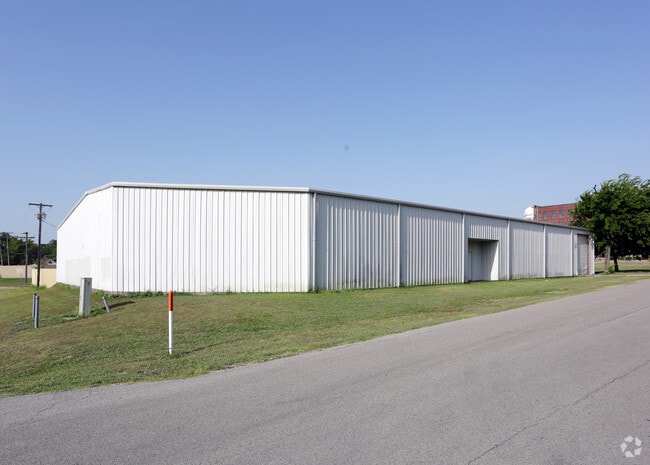
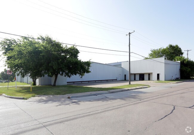
Property Record
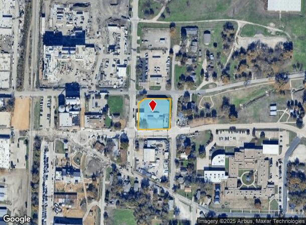
711 E Louisiana St, Mckinney, TX 75069

NEARBY LISTINGS FOR SALE OR LEASE
Property Detail
711 E Louisiana St
Dallas-Fort Worth-Arlington, TX
H & T C Railroad Addition (Cmc)
R-0898-012-0010-1
H & T C RAILROAD ADDITION, BLK 12, LOT 1
Publicschool
Collin
X
Texas
48085C0280J
1
0
0.90 AC
2025
Allen/McKinney
030901
Dallas/Ft Worth
30,264 SF
DEMOGRAPHICS near 711 E Louisiana St
1 Mile
3 Mile
5 Mile
2024 Total Population
10,704
46,668
123,339
2029 Population
13,111
57,115
150,622
Pop Growth 2024-2029
+ 22.49%
+ 22.39%
+ 22.12%
Average Age
36
38
39
2024 Total Households
3,579
17,468
43,563
HH Growth 2024-2029
+ 22.63%
+ 22.65%
+ 22.56%
Median Household Inc
$58,793
$66,014
$89,408
Avg Household Size
2.80
2.50
2.70
2024 Avg HH Vehicles
2.00
2.00
2.00
Median Home Value
$355,113
$316,961
$370,563
Median Year Built
1979
1995
2002
Nearby Places
Map Layers
Map Styles
 Street
 Aerial
- Restaurants
- Banks
- Shops
- Fitness
- Groceries
PUBLIC TRANSPORTATION
AIRPORT
Dallas Love Field
DRIVE
WALK
Distance
Dallas Love Field
46 min
34.3 mi
Dallas-Fort Worth International
DRIVE
WALK
Distance
Dallas-Fort Worth International
43 min
36.6 mi
Nearby Properties
Address
Land Use
TOTAL SIZE
Lot Size
Zoning
Address
Land Use
TOTAL SIZE
Lot Size
Zoning
1,826,199 SF
117.79 AC
Address
Land Use
TOTAL SIZE
Lot Size
Zoning
755,827 SF
52.76 AC
O
Address
Land Use
TOTAL SIZE
Lot Size
Zoning
475,847 SF
16.34 AC
RG-18
Address
Land Use
TOTAL SIZE
Lot Size
Zoning
879,029 SF
50.26 AC
ML
Address
Land Use
TOTAL SIZE
Lot Size
Zoning
727,459 SF
48.83 AC
Address
Land Use
TOTAL SIZE
Lot Size
Zoning
725,223 SF
46.60 AC
Address
Land Use
TOTAL SIZE
Lot Size
Zoning
321,982 SF
22.83 AC
SFR
Address
Land Use
TOTAL SIZE
Lot Size
Zoning
272,853 SF
17.32 AC
PD/ML
Address
Land Use
TOTAL SIZE
Lot Size
Zoning
1,708,448 SF
85.24 AC
Address
Land Use
TOTAL SIZE
Lot Size
Zoning
281,420 SF
9.43 AC
PD/ML
Address
Land Use
TOTAL SIZE
Lot Size
Zoning
697,149 SF
45.08 AC
Address
Land Use
TOTAL SIZE
Lot Size
Zoning
196,145 SF
18.05 AC
Address
Land Use
TOTAL SIZE
Lot Size
Zoning
201,484 SF
48.39 AC
PD/ML
Address
Land Use
TOTAL SIZE
Lot Size
Zoning
319,712 SF
69.85 AC
Address
Land Use
TOTAL SIZE
Lot Size
Zoning
232,400 SF
13.32 AC
RG-18
Address
Land Use
TOTAL SIZE
Lot Size
Zoning
193,037 SF
12.35 AC
MF-M
Address
Land Use
TOTAL SIZE
Lot Size
Zoning
244,074 SF
13.97 AC
Address
Land Use
TOTAL SIZE
Lot Size
Zoning
131,417 SF
12 AC
AG
Address
Land Use
TOTAL SIZE
Lot Size
Zoning
304,565 SF
23.05 AC
COMM
Address
Land Use
TOTAL SIZE
Lot Size
Zoning
298,992 SF
16.82 AC
LI
Address
Land Use
TOTAL SIZE
Lot Size
Zoning
174,624 SF
10.05 AC
Address
Land Use
TOTAL SIZE
Lot Size
Zoning
207,328 SF
15.10 AC
SFR
Address
Land Use
TOTAL SIZE
Lot Size
Zoning
279,356 SF
16.24 AC
COMM
Address
Land Use
TOTAL SIZE
Lot Size
Zoning
96,408 SF
16.65 AC
Address
Land Use
TOTAL SIZE
Lot Size
Zoning
167,735 SF
5.08 AC
PD
Address
Land Use
TOTAL SIZE
Lot Size
Zoning
119,230 SF
5.44 AC
Address
Land Use
TOTAL SIZE
Lot Size
Zoning
201,899 SF
9.77 AC
MF-M
Address
Land Use
TOTAL SIZE
Lot Size
Zoning
186,291 SF
11.13 AC
Address
Land Use
TOTAL SIZE
Lot Size
Zoning
195,589 SF
12.54 AC
RG-18
Address
Land Use
TOTAL SIZE
Lot Size
Zoning
144,545 SF
13.21 AC
COMM MULTI
The World's #1 Commercial Real Estate Marketplace
Connect with us
© 2026 CoStar Group
The information above has been obtained from sources believed reliable. While we do not doubt its accuracy we have not verified it and make no guarantee, warranty or representation about it. It is your responsibility to independently confirm its accuracy and completeness. Any projections, opinions, assumptions, or estimates used are for example only and do not represent the current or future performance of the property. The value of this transaction to you depends on tax and other factors which should be evaluated by your tax, financial, and legal advisors. You and your advisors should conduct a careful, independent investigation of the property to determine to your satisfaction the suitability of the property for your needs.