Property Record
770 Nw 101St St, Miami, FL 33150


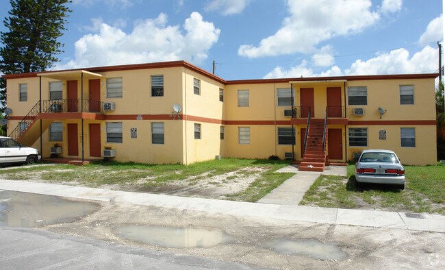
Property Detail
770 Nw 101St St
30-3102-012-0840
WEST BISCAYNE PB 7-58 LOT 8 LESS E12FT & N5FT & LOT 9 LESS N5FT & LOT 10 LESS N70FT OF W20FT & LESS N5FT OF E30FT & LOTS 15 & 16 LESS S5FT & LOT 17 LESS E12FT & S5FT FOR R/W BLK 5 LOT SIZE 38720 SQ FT DB 3941-465 OR 16564-4003 1094 6
Multifamilydwelling
Miami-Dade
5000
Florida
B and X Area of moderate flood hazard, usually the area between the limits of the 100-year and 500-year floods.
8-10
2024
0.89 AC
2025
Pinewood
000408
South Florida
19,185 SF
Miami-Miami Beach-Kendall, FL
NEARBY LISTINGS FOR SALE OR LEASE
DEMOGRAPHICS near 770 Nw 101St St
1 mile
3 mile
5 mile
2025 Total Population
23,000
206,803
506,728
2030 Population
24,288
221,661
543,867
Pop Growth 2025-2030
+ 5.60%
+ 7.18%
+ 7.33%
Average Age
40
40
41
2025 Total Households
7,297
70,781
177,637
HH Growth 2025-2030
+ 5.58%
+ 7.31%
+ 7.55%
Median Household Inc
$62,237
$55,038
$57,736
Avg Household Size
2.90
2.80
2.70
2025 Avg HH Vehicles
2.00
1.00
2.00
Median Home Value
$478,579
$451,882
$442,073
Median Year Built
1956
1961
1964
Nearby Places
Map Layers
Map Styles
 Street
 Aerial
Layers
 Traffic
 Biking
Places
Listings with unknown addresses are not visible on the map
- Restaurants
- Banks
- Shops
- Fitness
- Groceries
PUBLIC TRANSPORTATION
COMMUTER RAIL
Northside (Metrorail Green Line - Miami-Dade Transit (Metrorail/Metromover))
Drive
Walk
Distance
Northside (Metrorail Green Line - Miami-Dade Transit (Metrorail/Metromover))
8 min
4.1 mi
Dr. Martin Luther King Jr. Plaza (Metrorail Green Line - Miami-Dade Transit (Metrorail/Metromover))
Drive
Walk
Distance
Dr. Martin Luther King Jr. Plaza (Metrorail Green Line - Miami-Dade Transit (Metrorail/Metromover))
9 min
4.4 mi
AIRPORT
Miami International
Drive
Walk
Distance
Miami International
24 min
12.2 mi
Fort Lauderdale/Hollywood International
Drive
Walk
Distance
Fort Lauderdale/Hollywood International
25 min
16.8 mi
Freight Ports
Port of Miami
Drive
Walk
Distance
Port of Miami
16 min
8.8 mi
Nearby Properties
Address
Land Use
TOTAL SIZE
Lot Size
Zoning
Address
Land Use
TOTAL SIZE
Lot Size
Zoning
768,663 SF
2.85 AC
4600
Address
Land Use
TOTAL SIZE
Lot Size
Zoning
657,769 SF
6.12 AC
6200
Address
Land Use
TOTAL SIZE
Lot Size
Zoning
516,192 SF
4.01 AC
3800
Address
Land Use
TOTAL SIZE
Lot Size
Zoning
968,497 SF
58.61 AC
7100
Address
Land Use
TOTAL SIZE
Lot Size
Zoning
520,016 SF
1.89 AC
5000
Address
Land Use
TOTAL SIZE
Lot Size
Zoning
803,285 SF
63.32 AC
7100
Address
Land Use
TOTAL SIZE
Lot Size
Zoning
446,109 SF
3.54 AC
4600
Address
Land Use
TOTAL SIZE
Lot Size
Zoning
656,930 SF
37.70 AC
8200
Address
Land Use
TOTAL SIZE
Lot Size
Zoning
363,010 SF
19.13 AC
8000
Address
Land Use
TOTAL SIZE
Lot Size
Zoning
73,727 SF
232.58 AC
8054
Address
Land Use
TOTAL SIZE
Lot Size
Zoning
272,311 SF
9.64 AC
3800
Address
Land Use
TOTAL SIZE
Lot Size
Zoning
306,056 SF
7.75 AC
9300
Address
Land Use
TOTAL SIZE
Lot Size
Zoning
680,945 SF
35.56 AC
6400
Address
Land Use
TOTAL SIZE
Lot Size
Zoning
11,333 SF
7.11 AC
9000
Address
Land Use
TOTAL SIZE
Lot Size
Zoning
569,763 SF
31.75 AC
3900
Address
Land Use
TOTAL SIZE
Lot Size
Zoning
293,276 SF
39.44 AC
8200
Address
Land Use
TOTAL SIZE
Lot Size
Zoning
204,447 SF
12.29 AC
0100
Address
Land Use
TOTAL SIZE
Lot Size
Zoning
197,181 SF
7.95 AC
6062
Address
Land Use
TOTAL SIZE
Lot Size
Zoning
244,374 SF
20.29 AC
7052
Address
Land Use
TOTAL SIZE
Lot Size
Zoning
136,431 SF
10.98 AC
6200
Address
Land Use
TOTAL SIZE
Lot Size
Zoning
208,527 SF
2.55 AC
6100
Address
Land Use
TOTAL SIZE
Lot Size
Zoning
343,553 SF
12.08 AC
7100
Address
Land Use
TOTAL SIZE
Lot Size
Zoning
504,970 SF
29.65 AC
5000
Address
Land Use
TOTAL SIZE
Lot Size
Zoning
213,337 SF
16.54 AC
0400
Address
Land Use
TOTAL SIZE
Lot Size
Zoning
127,562 SF
3.69 AC
7700
Address
Land Use
TOTAL SIZE
Lot Size
Zoning
161,909 SF
5.01 AC
6061
Address
Land Use
TOTAL SIZE
Lot Size
Zoning
277,425 SF
12.25 AC
7100
Address
Land Use
TOTAL SIZE
Lot Size
Zoning
107,203 SF
11.85 AC
6062
Address
Land Use
TOTAL SIZE
Lot Size
Zoning
498,790 SF
5.84 AC
5100
Address
Land Use
TOTAL SIZE
Lot Size
Zoning
132,358 SF
5.82 AC
7100
The World's #1 Commercial Real Estate Marketplace
Connect with us
© 2026 CoStar Group
The information above has been obtained from sources believed reliable. While we do not doubt its accuracy we have not verified it and make no guarantee, warranty or representation about it. It is your responsibility to independently confirm its accuracy and completeness. Any projections, opinions, assumptions, or estimates used are for example only and do not represent the current or future performance of the property. The value of this transaction to you depends on tax and other factors which should be evaluated by your tax, financial, and legal advisors. You and your advisors should conduct a careful, independent investigation of the property to determine to your satisfaction the suitability of the property for your needs.