Property Record
78 Ridge Rd, Hartwell, GA 30643

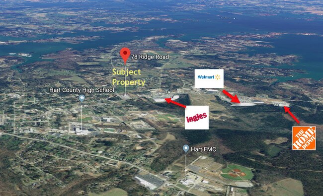

Property Detail
78 Ridge Rd
Autorepair
GMD 1112 PB 2I-15
R1
Hart
B and X Area of moderate flood hazard, usually the area between the limits of the 100-year and 500-year floods.
Georgia
2025
5.07 AC
2025
Georgia Northeast
960503
Other Market Areas
9,740 SF
I70B-013
NEARBY LISTINGS FOR SALE OR LEASE
DEMOGRAPHICS near 78 Ridge Rd
1 mile
3 mile
5 mile
2025 Total Population
2,576
9,611
14,434
2030 Population
2,724
10,176
15,383
Pop Growth 2025-2030
+ 5.75%
+ 5.88%
+ 6.57%
Average Age
42
44
44
2025 Total Households
1,046
3,878
5,817
HH Growth 2025-2030
+ 5.74%
+ 5.93%
+ 6.69%
Median Household Inc
$49,898
$53,063
$55,217
Avg Household Size
2.30
2.30
2.30
2025 Avg HH Vehicles
2.00
2.00
2.00
Median Home Value
$221,381
$247,158
$252,396
Median Year Built
1985
1982
1986
Nearby Places
Map Layers
Map Styles
 Street
 Aerial
Layers
 Traffic
 Biking
Places
Listings with unknown addresses are not visible on the map
- Restaurants
- Banks
- Shops
- Fitness
- Groceries
SALE & LEASE HISTORY
LISTING DATE
SALE/LEASE

Jul 19, 2019
For Sale
Nearby Properties
Address
Land Use
TOTAL SIZE
Lot Size
Zoning
Address
Land Use
TOTAL SIZE
Lot Size
Zoning
500,076 SF
131.11 AC
Address
Land Use
TOTAL SIZE
Lot Size
Zoning
134,608 SF
20.66 AC
Address
Land Use
TOTAL SIZE
Lot Size
Zoning
235,162 SF
27.95 AC
Address
Land Use
TOTAL SIZE
Lot Size
Zoning
387,532 SF
30.39 AC
I
Address
Land Use
TOTAL SIZE
Lot Size
Zoning
84,700 SF
8.73 AC
Address
Land Use
TOTAL SIZE
Lot Size
Zoning
2,786 SF
6 AC
R1
Address
Land Use
TOTAL SIZE
Lot Size
Zoning
58,618 SF
9.60 AC
B2
Address
Land Use
TOTAL SIZE
Lot Size
Zoning
16,564 SF
363.95 AC
Address
Land Use
TOTAL SIZE
Lot Size
Zoning
17,948 SF
12.73 AC
Address
Land Use
TOTAL SIZE
Lot Size
Zoning
35,264 SF
348.03 AC
Address
Land Use
TOTAL SIZE
Lot Size
Zoning
24,176 SF
10.68 AC
Address
Land Use
TOTAL SIZE
Lot Size
Zoning
6,560 SF
22.01 AC
Address
Land Use
TOTAL SIZE
Lot Size
Zoning
2,552 SF
37.22 AC
B2
Address
Land Use
TOTAL SIZE
Lot Size
Zoning
48,127 SF
5.05 AC
R1
Address
Land Use
TOTAL SIZE
Lot Size
Zoning
131,870 SF
10.80 AC
M2
Address
Land Use
TOTAL SIZE
Lot Size
Zoning
32,796 SF
7.27 AC
I
Address
Land Use
TOTAL SIZE
Lot Size
Zoning
19,200 SF
2.66 AC
B2
Address
Land Use
TOTAL SIZE
Lot Size
Zoning
28,009 SF
2.89 AC
B1
Address
Land Use
TOTAL SIZE
Lot Size
Zoning
57,456 SF
14.88 AC
Address
Land Use
TOTAL SIZE
Lot Size
Zoning
64,960 SF
8.16 AC
Address
Land Use
TOTAL SIZE
Lot Size
Zoning
18,240 SF
1.56 AC
B2
Address
Land Use
TOTAL SIZE
Lot Size
Zoning
2,288 SF
5.84 AC
Address
Land Use
TOTAL SIZE
Lot Size
Zoning
24,430 SF
4.29 AC
B2
Address
Land Use
TOTAL SIZE
Lot Size
Zoning
18,838 SF
2.68 AC
B2
Address
Land Use
TOTAL SIZE
Lot Size
Zoning
10.98 AC
Address
Land Use
TOTAL SIZE
Lot Size
Zoning
25,419 SF
4.11 AC
M2
Address
Land Use
TOTAL SIZE
Lot Size
Zoning
10,362 SF
2.50 AC
Address
Land Use
TOTAL SIZE
Lot Size
Zoning
12,298 SF
1.50 AC
B2
The World's #1 Commercial Real Estate Marketplace
Connect with us
© 2026 CoStar Group
The information above has been obtained from sources believed reliable. While we do not doubt its accuracy we have not verified it and make no guarantee, warranty or representation about it. It is your responsibility to independently confirm its accuracy and completeness. Any projections, opinions, assumptions, or estimates used are for example only and do not represent the current or future performance of the property. The value of this transaction to you depends on tax and other factors which should be evaluated by your tax, financial, and legal advisors. You and your advisors should conduct a careful, independent investigation of the property to determine to your satisfaction the suitability of the property for your needs.