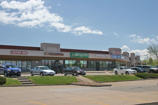
Property Record
830-894 S Buckley Rd, Aurora, CO 80017


Current Lease Availabilities
NEARBY LISTINGS FOR SALE OR LEASE
Property Detail
830-894 S Buckley Rd
Denver-Aurora-Lakewood, CO
Bristol Commercial Center Sub 1St Flg
1975-16-3-21-001
SUBDIVISIONCD 006355 SUBDIVISIONNAME BRISTOL COMMERCIAL CENTER SUB 1ST FLG BLOCK 001 LOT 001 LOT 1 BLK 1 BRISTOL COMMERCIAL CENTER SUB 1ST FLG
Storebuilding
Arapahoe
X
Colorado
08005C0183L
1
2023
3.64 AC
2024
Aurora
082600
Denver
30,212 SF
DEMOGRAPHICS near 830-894 S Buckley Rd
1 Mile
3 Mile
5 Mile
2024 Total Population
23,558
131,392
330,156
2029 Population
23,614
131,839
332,444
Pop Growth 2024-2029
+ 0.24%
+ 0.34%
+ 0.69%
Average Age
35
37
38
2024 Total Households
8,612
48,500
124,213
HH Growth 2024-2029
+ 0.27%
+ 0.41%
+ 0.73%
Median Household Inc
$64,211
$66,073
$67,030
Avg Household Size
2.60
2.60
2.50
2024 Avg HH Vehicles
2.00
2.00
2.00
Median Home Value
$357,385
$355,240
$377,113
Median Year Built
1985
1983
1982
Nearby Places
Map Layers
Map Styles
 Street
 Aerial
- Restaurants
- Banks
- Shops
- Fitness
- Groceries
PUBLIC TRANSPORTATION
COMMUTER RAIL
40Th Ave & Airport Blvd - Gateway Park Station Track 2 (Union Station to Denver Airport Station - Regional Transportation District)
DRIVE
WALK
Distance
40Th Ave & Airport Blvd - Gateway Park Station Track 2 (Union Station to Denver Airport Station - Regional Transportation District)
12 min
5.8 mi
Peoria Station Track 1 (Union Station to Denver Airport Station - Regional Transportation District)
DRIVE
WALK
Distance
Peoria Station Track 1 (Union Station to Denver Airport Station - Regional Transportation District)
14 min
8.2 mi
AIRPORT
Denver International
DRIVE
WALK
Distance
Denver International
23 min
16.3 mi
Freight Ports
Tulsa Port Of Catoosa
DRIVE
WALK
Distance
Tulsa Port Of Catoosa
718 min
699.3 mi
Nearby Properties
Address
Land Use
TOTAL SIZE
Lot Size
Zoning
Address
Land Use
TOTAL SIZE
Lot Size
Zoning
496,493 SF
33.45 AC
Address
Land Use
TOTAL SIZE
Lot Size
Zoning
876,549 SF
46.65 AC
Address
Land Use
TOTAL SIZE
Lot Size
Zoning
277,940 SF
31.61 AC
Address
Land Use
TOTAL SIZE
Lot Size
Zoning
140.42 AC
Address
Land Use
TOTAL SIZE
Lot Size
Zoning
315,058 SF
36.85 AC
RPCZD
Address
Land Use
TOTAL SIZE
Lot Size
Zoning
277,985 SF
19.07 AC
Address
Land Use
TOTAL SIZE
Lot Size
Zoning
201,600 SF
44.67 AC
R1
Address
Land Use
TOTAL SIZE
Lot Size
Zoning
364,024 SF
23.23 AC
PUD
Address
Land Use
TOTAL SIZE
Lot Size
Zoning
220,395 SF
7.93 AC
Address
Land Use
TOTAL SIZE
Lot Size
Zoning
186,088 SF
10.15 AC
RZIND
Address
Land Use
TOTAL SIZE
Lot Size
Zoning
176,751 SF
28.75 AC
Address
Land Use
TOTAL SIZE
Lot Size
Zoning
462,048 SF
5.34 AC
RB3
Address
Land Use
TOTAL SIZE
Lot Size
Zoning
521,364 SF
14.88 AC
PUD
Address
Land Use
TOTAL SIZE
Lot Size
Zoning
328,315 SF
8.15 AC
Address
Land Use
TOTAL SIZE
Lot Size
Zoning
127,530 SF
20.76 AC
Address
Land Use
TOTAL SIZE
Lot Size
Zoning
215,175 SF
28.07 AC
Address
Land Use
TOTAL SIZE
Lot Size
Zoning
114,539 SF
5.35 AC
Address
Land Use
TOTAL SIZE
Lot Size
Zoning
345,688 SF
15.15 AC
PUD
Address
Land Use
TOTAL SIZE
Lot Size
Zoning
145,510 SF
9.61 AC
Address
Land Use
TOTAL SIZE
Lot Size
Zoning
135,050 SF
19.38 AC
Address
Land Use
TOTAL SIZE
Lot Size
Zoning
398,436 SF
28.13 AC
Address
Land Use
TOTAL SIZE
Lot Size
Zoning
146,784 SF
10.58 AC
Address
Land Use
TOTAL SIZE
Lot Size
Zoning
92,228 SF
12.39 AC
PUD
Address
Land Use
TOTAL SIZE
Lot Size
Zoning
187,528 SF
6.15 AC
Address
Land Use
TOTAL SIZE
Lot Size
Zoning
265,326 SF
12.31 AC
RAOD
Address
Land Use
TOTAL SIZE
Lot Size
Zoning
325,111 SF
18.13 AC
PUD
Address
Land Use
TOTAL SIZE
Lot Size
Zoning
193,200 SF
15.09 AC
Address
Land Use
TOTAL SIZE
Lot Size
Zoning
122,790 SF
14.48 AC
Address
Land Use
TOTAL SIZE
Lot Size
Zoning
307,372 SF
7.15 AC
The World's #1 Commercial Real Estate Marketplace
Connect with us
© 2025 CoStar Group
The information above has been obtained from sources believed reliable. While we do not doubt its accuracy we have not verified it and make no guarantee, warranty or representation about it. It is your responsibility to independently confirm its accuracy and completeness. Any projections, opinions, assumptions, or estimates used are for example only and do not represent the current or future performance of the property. The value of this transaction to you depends on tax and other factors which should be evaluated by your tax, financial, and legal advisors. You and your advisors should conduct a careful, independent investigation of the property to determine to your satisfaction the suitability of the property for your needs.