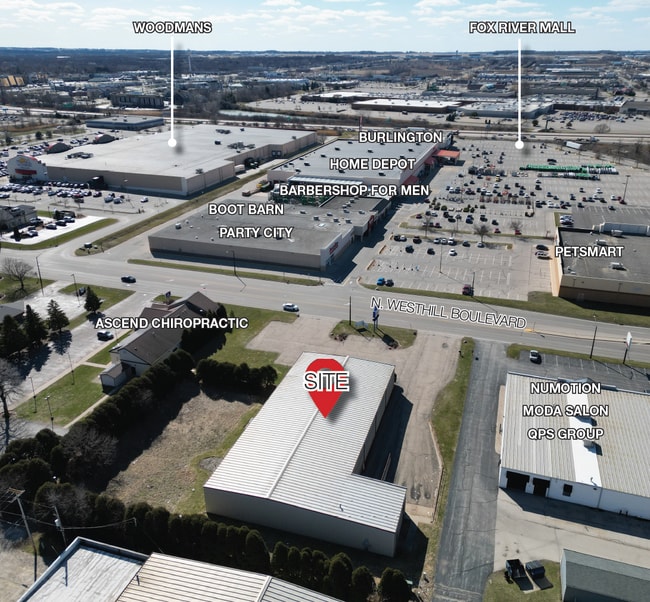
Property Record
846 N Westhill Blvd, Appleton, WI 54914


Save to a Folder
{{folder.Name}}
{{folder.ListingIds.length}} Properties
{{folder.ListingIds.length}} Property
Create a New Folder
Property Detail
846 N Westhill Blvd
10-1-1185-01
COM E1/4 COR SEC29 N1355.60FT W988FT TO POB S210FT W325.31FT N200FT E325.30FT TO POB PRT NE SEC29 T21N R17E 1.53AC M/L
Commercialnec
Outagamie
B and X Area of moderate flood hazard, usually the area between the limits of the 100-year and 500-year floods.
Wisconsin
2024
1.38 AC
2025
Outagamie County
011104
Green Bay
11,430 SF
Appleton, WI
NEARBY LISTINGS FOR SALE OR LEASE
DEMOGRAPHICS near 846 N Westhill Blvd
1 mile
3 mile
5 mile
2025 Total Population
3,099
52,528
133,957
2030 Population
3,150
53,280
136,370
Pop Growth 2025-2030
+ 1.65%
+ 1.43%
+ 1.80%
Average Age
39
40
40
2025 Total Households
1,477
22,728
56,031
HH Growth 2025-2030
+ 1.69%
+ 1.49%
+ 1.87%
Median Household Inc
$64,596
$74,595
$78,119
Avg Household Size
2.00
2.20
2.30
2025 Avg HH Vehicles
1.00
2.00
2.00
Median Home Value
$241,145
$242,060
$246,468
Median Year Built
1984
1975
1976
Nearby Places
Map Layers
Map Styles
 Street
 Aerial
Layers
 Traffic
 Biking
Places
Listings with unknown addresses are not visible on the map
- Restaurants
- Banks
- Shops
- Fitness
- Groceries
PUBLIC TRANSPORTATION
AIRPORT
Appleton International
Drive
Walk
Distance
Appleton International
11 min
5.9 mi
Green Bay/Austin Straubel International
Drive
Walk
Distance
Green Bay/Austin Straubel International
37 min
29.8 mi
Freight Ports
Port Milwaukee
Drive
Walk
Distance
Port Milwaukee
124 min
107.7 mi
SALE & LEASE HISTORY
LISTING DATE
SALE/LEASE

May 23, 2023
For Sale
Mar 27, 2024
For Sale
Mar 22, 2024
For Lease
Nearby Properties
Address
Land Use
TOTAL SIZE
Lot Size
Zoning
Address
Land Use
TOTAL SIZE
Lot Size
Zoning
645,392 SF
25.87 AC
Address
Land Use
TOTAL SIZE
Lot Size
Zoning
500,700 SF
47.17 AC
Address
Land Use
TOTAL SIZE
Lot Size
Zoning
8.61 AC
R5
Address
Land Use
TOTAL SIZE
Lot Size
Zoning
46,300 SF
23.21 AC
M2
Address
Land Use
TOTAL SIZE
Lot Size
Zoning
37,900 SF
0.67 AC
Address
Land Use
TOTAL SIZE
Lot Size
Zoning
194,573 SF
19.99 AC
Address
Land Use
TOTAL SIZE
Lot Size
Zoning
267,069 SF
26.76 AC
Address
Land Use
TOTAL SIZE
Lot Size
Zoning
18.34 AC
Address
Land Use
TOTAL SIZE
Lot Size
Zoning
278,801 SF
20.94 AC
Address
Land Use
TOTAL SIZE
Lot Size
Zoning
34,232 SF
18.18 AC
Address
Land Use
TOTAL SIZE
Lot Size
Zoning
Address
Land Use
TOTAL SIZE
Lot Size
Zoning
194,738 SF
19.73 AC
Address
Land Use
TOTAL SIZE
Lot Size
Zoning
148,743 SF
17.58 AC
Address
Land Use
TOTAL SIZE
Lot Size
Zoning
191,466 SF
1.21 AC
CBD
Address
Land Use
TOTAL SIZE
Lot Size
Zoning
249,444 SF
18.81 AC
Address
Land Use
TOTAL SIZE
Lot Size
Zoning
81,252 SF
8.32 AC
Address
Land Use
TOTAL SIZE
Lot Size
Zoning
15,560 SF
15.24 AC
Address
Land Use
TOTAL SIZE
Lot Size
Zoning
53,321 SF
2.51 AC
CBD
Address
Land Use
TOTAL SIZE
Lot Size
Zoning
30.16 AC
Address
Land Use
TOTAL SIZE
Lot Size
Zoning
39,510 SF
7.73 AC
Address
Land Use
TOTAL SIZE
Lot Size
Zoning
44,164 SF
0.62 AC
CBD
Address
Land Use
TOTAL SIZE
Lot Size
Zoning
22.26 AC
Address
Land Use
TOTAL SIZE
Lot Size
Zoning
166,336 SF
8.94 AC
Address
Land Use
TOTAL SIZE
Lot Size
Zoning
25.59 AC
Address
Land Use
TOTAL SIZE
Lot Size
Zoning
23,134 SF
0.08 AC
Address
Land Use
TOTAL SIZE
Lot Size
Zoning
15.06 AC
Address
Land Use
TOTAL SIZE
Lot Size
Zoning
38,186 SF
2.83 AC
Address
Land Use
TOTAL SIZE
Lot Size
Zoning
189,722 SF
21.52 AC
Address
Land Use
TOTAL SIZE
Lot Size
Zoning
23.68 AC
Address
Land Use
TOTAL SIZE
Lot Size
Zoning
20.92 AC
R5
The World's #1 Commercial Real Estate Marketplace
Connect with us
© 2026 CoStar Group
The information above has been obtained from sources believed reliable. While we do not doubt its accuracy we have not verified it and make no guarantee, warranty or representation about it. It is your responsibility to independently confirm its accuracy and completeness. Any projections, opinions, assumptions, or estimates used are for example only and do not represent the current or future performance of the property. The value of this transaction to you depends on tax and other factors which should be evaluated by your tax, financial, and legal advisors. You and your advisors should conduct a careful, independent investigation of the property to determine to your satisfaction the suitability of the property for your needs.