Property Record
8910 N 3Rd St, Phoenix, AZ 85020
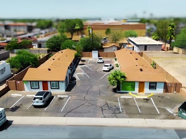
This Property Is For Sale
NEARBY LISTINGS FOR SALE OR LEASE
Property Detail
8910 N 3Rd St
Phoenix-Mesa-Chandler, AZ
Sunnyslope
160-50-087
SUNNYSLOPE MCR 4-54
Commercialnec
Maricopa
X
Arizona
04013C1730L
20
2025
0.14 AC
2025
North Mountain
105300
Phoenix
DEMOGRAPHICS near 8910 N 3Rd St
1 mile
3 mile
5 mile
2024 Total Population
18,386
123,709
383,308
2029 Population
19,933
134,188
414,624
Pop Growth 2024-2029
+ 8.41%
+ 8.47%
+ 8.17%
Average Age
40
40
38
2024 Total Households
7,810
52,792
153,337
HH Growth 2024-2029
+ 8.50%
+ 8.68%
+ 8.54%
Median Household Inc
$66,362
$62,472
$63,380
Avg Household Size
2.30
2.30
2.40
2024 Avg HH Vehicles
2.00
2.00
2.00
Median Home Value
$441,705
$454,498
$380,399
Median Year Built
1969
1975
1975
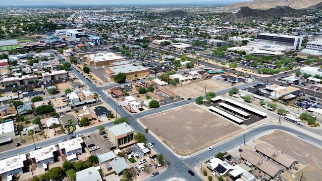
Nearby Places
Map Layers
Map Styles
 Street
 Aerial
Transit
 Traffic
 Biking
Places
Listings with unknown addresses are not visible on the map
- Restaurants
- Banks
- Shops
- Fitness
- Groceries
PUBLIC TRANSPORTATION
AIRPORT
Phoenix Sky Harbor International
Drive
Walk
Distance
Phoenix Sky Harbor International
23 min
13.0 mi
Phoenix-Mesa Gateway
Drive
Walk
Distance
Phoenix-Mesa Gateway
57 min
40.2 mi
Nearby Properties
Address
Land Use
TOTAL SIZE
Lot Size
Zoning
Address
Land Use
TOTAL SIZE
Lot Size
Zoning
98,760 SF
6.76 AC
A-1
Address
Land Use
TOTAL SIZE
Lot Size
Zoning
63,018 SF
4.77 AC
C-T
Address
Land Use
TOTAL SIZE
Lot Size
Zoning
3.58 AC
Address
Land Use
TOTAL SIZE
Lot Size
Zoning
19,474 SF
8.43 AC
C-3
Address
Land Use
TOTAL SIZE
Lot Size
Zoning
21,587 SF
3.66 AC
R-10
Address
Land Use
TOTAL SIZE
Lot Size
Zoning
558,361 SF
14.61 AC
C-2
Address
Land Use
TOTAL SIZE
Lot Size
Zoning
367,399 SF
14.88 AC
C-1
Address
Land Use
TOTAL SIZE
Lot Size
Zoning
515,418 SF
19.72 AC
R-3
Address
Land Use
TOTAL SIZE
Lot Size
Zoning
215,150 SF
13.24 AC
R-3
Address
Land Use
TOTAL SIZE
Lot Size
Zoning
16,284 SF
3.77 AC
M-H
Address
Land Use
TOTAL SIZE
Lot Size
Zoning
7,665 SF
1.29 AC
C-T
Address
Land Use
TOTAL SIZE
Lot Size
Zoning
452,506 SF
55.11 AC
RH
Address
Land Use
TOTAL SIZE
Lot Size
Zoning
146,867 SF
12.95 AC
CPGCP
Address
Land Use
TOTAL SIZE
Lot Size
Zoning
194,523 SF
37.27 AC
R-6
Address
Land Use
TOTAL SIZE
Lot Size
Zoning
394,793 SF
3.60 AC
PUD
Address
Land Use
TOTAL SIZE
Lot Size
Zoning
584,674 SF
27.83 AC
R-3A
Address
Land Use
TOTAL SIZE
Lot Size
Zoning
349,252 SF
15.11 AC
Address
Land Use
TOTAL SIZE
Lot Size
Zoning
362,729 SF
21.85 AC
Address
Land Use
TOTAL SIZE
Lot Size
Zoning
398,829 SF
11.66 AC
M-H
Address
Land Use
TOTAL SIZE
Lot Size
Zoning
99,714 SF
11.72 AC
R-6
Address
Land Use
TOTAL SIZE
Lot Size
Zoning
533,505 SF
27.69 AC
Address
Land Use
TOTAL SIZE
Lot Size
Zoning
123,370 SF
0.82 AC
C-C
Address
Land Use
TOTAL SIZE
Lot Size
Zoning
154,128 SF
9.32 AC
I-1
Address
Land Use
TOTAL SIZE
Lot Size
Zoning
302,016 SF
28.06 AC
Address
Land Use
TOTAL SIZE
Lot Size
Zoning
231,327 SF
5.46 AC
M-H
Address
Land Use
TOTAL SIZE
Lot Size
Zoning
84,738 SF
8.83 AC
R-6
Address
Land Use
TOTAL SIZE
Lot Size
Zoning
362,106 SF
15.60 AC
M-H
Address
Land Use
TOTAL SIZE
Lot Size
Zoning
110,623 SF
4.39 AC
R-10
Address
Land Use
TOTAL SIZE
Lot Size
Zoning
122,646 SF
14.69 AC
I-P
Address
Land Use
TOTAL SIZE
Lot Size
Zoning
339,043 SF
5.43 AC
C-O
The World's #1 Commercial Real Estate Marketplace
Connect with us
© 2026 CoStar Group
The information above has been obtained from sources believed reliable. While we do not doubt its accuracy we have not verified it and make no guarantee, warranty or representation about it. It is your responsibility to independently confirm its accuracy and completeness. Any projections, opinions, assumptions, or estimates used are for example only and do not represent the current or future performance of the property. The value of this transaction to you depends on tax and other factors which should be evaluated by your tax, financial, and legal advisors. You and your advisors should conduct a careful, independent investigation of the property to determine to your satisfaction the suitability of the property for your needs.