Property Record
8939 La Mesa Blvd, La Mesa, CA 91942
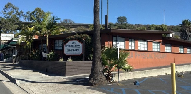


Property Detail
8939 La Mesa Blvd
490-472-21
BLK A LOTS 19&20 DOC94-715010 IN TR 001865
Storesoffices
San Diego
C
California
B and X Area of moderate flood hazard, usually the area between the limits of the 100-year and 500-year floods.
19,20
2024
0.47 AC
2025
East County
014902
San Diego
5,375 SF
San Diego-Chula Vista-Carlsbad, CA
NEARBY LISTINGS FOR SALE OR LEASE
DEMOGRAPHICS near 8939 La Mesa Blvd
1 mile
3 mile
5 mile
2025 Total Population
14,449
159,148
436,041
2030 Population
14,450
159,312
436,017
Pop Growth 2025-2030
+ 0.01%
+ 0.10%
(0.01%)
Average Age
41
40
39
2025 Total Households
5,753
59,555
151,611
HH Growth 2025-2030
(0.14%)
+ 0.01%
(0.13%)
Median Household Inc
$92,206
$95,731
$90,646
Avg Household Size
2.40
2.60
2.70
2025 Avg HH Vehicles
2.00
2.00
2.00
Median Home Value
$830,484
$787,623
$754,887
Median Year Built
1967
1968
1972
Nearby Places
Map Layers
Map Styles
 Street
 Aerial
Layers
 Traffic
 Biking
Places
Listings with unknown addresses are not visible on the map
- Restaurants
- Banks
- Shops
- Fitness
- Groceries
PUBLIC TRANSPORTATION
TRANSIT/SUBWAY
Grossmont Transit Center (Green Line - San Diego Metropolitan Transit System Trolley (San Diego Trolley), Orange Line - San Diego Metropolitan Transit System Trolley (San Diego Trolley))
Drive
Walk
Distance
Grossmont Transit Center (Green Line - San Diego Metropolitan Transit System Trolley (San Diego Trolley), Orange Line - San Diego Metropolitan Transit System Trolley (San Diego Trolley))
1 min
14 min
0.7 mi
AIRPORT
San Diego International
Drive
Walk
Distance
San Diego International
20 min
14.7 mi
Freight Ports
Port of San Diego
Drive
Walk
Distance
Port of San Diego
17 min
12.1 mi
SALE & LEASE HISTORY
LISTING DATE
SALE/LEASE

Oct 27, 2016
For Lease
Oct 27, 2016
For Sale
Mar 13, 2020
For Lease
Mar 01, 2024
For Lease
Jun 20, 2023
For Sale
Nearby Properties
Address
Land Use
TOTAL SIZE
Lot Size
Zoning
Address
Land Use
TOTAL SIZE
Lot Size
Zoning
30.38 AC
RB
Address
Land Use
TOTAL SIZE
Lot Size
Zoning
62.04 AC
C
Address
Land Use
TOTAL SIZE
Lot Size
Zoning
6.79 AC
C
Address
Land Use
TOTAL SIZE
Lot Size
Zoning
4.77 AC
C
Address
Land Use
TOTAL SIZE
Lot Size
Zoning
8.65 AC
R3
Address
Land Use
TOTAL SIZE
Lot Size
Zoning
7.46 AC
RM-2200
Address
Land Use
TOTAL SIZE
Lot Size
Zoning
5.90 AC
RM-2200
Address
Land Use
TOTAL SIZE
Lot Size
Zoning
92,500 SF
7.05 AC
R3
Address
Land Use
TOTAL SIZE
Lot Size
Zoning
2.82 AC
R3
Address
Land Use
TOTAL SIZE
Lot Size
Zoning
4.10 AC
RB
Address
Land Use
TOTAL SIZE
Lot Size
Zoning
11.28 AC
C
Address
Land Use
TOTAL SIZE
Lot Size
Zoning
9,999 SF
5.47 AC
R3
Address
Land Use
TOTAL SIZE
Lot Size
Zoning
6.14 AC
R3
Address
Land Use
TOTAL SIZE
Lot Size
Zoning
13.48 AC
CC-1-3
Address
Land Use
TOTAL SIZE
Lot Size
Zoning
Address
Land Use
TOTAL SIZE
Lot Size
Zoning
84,900 SF
3.54 AC
R3
Address
Land Use
TOTAL SIZE
Lot Size
Zoning
92,988 SF
6.12 AC
RB
Address
Land Use
TOTAL SIZE
Lot Size
Zoning
5.17 AC
R3
Address
Land Use
TOTAL SIZE
Lot Size
Zoning
89,332 SF
1.14 AC
C
Address
Land Use
TOTAL SIZE
Lot Size
Zoning
83,198 SF
5 AC
RM-2200
Address
Land Use
TOTAL SIZE
Lot Size
Zoning
6.72 AC
RM-3-7
Address
Land Use
TOTAL SIZE
Lot Size
Zoning
63,964 SF
5.25 AC
R3
Address
Land Use
TOTAL SIZE
Lot Size
Zoning
4.49 AC
RM-5-12
Address
Land Use
TOTAL SIZE
Lot Size
Zoning
96,664 SF
1.63 AC
CIVIC CENT
Address
Land Use
TOTAL SIZE
Lot Size
Zoning
98,752 SF
4.10 AC
RU
Address
Land Use
TOTAL SIZE
Lot Size
Zoning
1.25 AC
C
Address
Land Use
TOTAL SIZE
Lot Size
Zoning
77,930 SF
2.34 AC
O-P
Address
Land Use
TOTAL SIZE
Lot Size
Zoning
10.89 AC
CM
Address
Land Use
TOTAL SIZE
Lot Size
Zoning
16.33 AC
C-R
Address
Land Use
TOTAL SIZE
Lot Size
Zoning
1.89 AC
C-R
The World's #1 Commercial Real Estate Marketplace
Connect with us
© 2026 CoStar Group
The information above has been obtained from sources believed reliable. While we do not doubt its accuracy we have not verified it and make no guarantee, warranty or representation about it. It is your responsibility to independently confirm its accuracy and completeness. Any projections, opinions, assumptions, or estimates used are for example only and do not represent the current or future performance of the property. The value of this transaction to you depends on tax and other factors which should be evaluated by your tax, financial, and legal advisors. You and your advisors should conduct a careful, independent investigation of the property to determine to your satisfaction the suitability of the property for your needs.