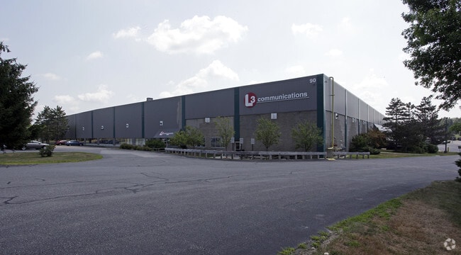
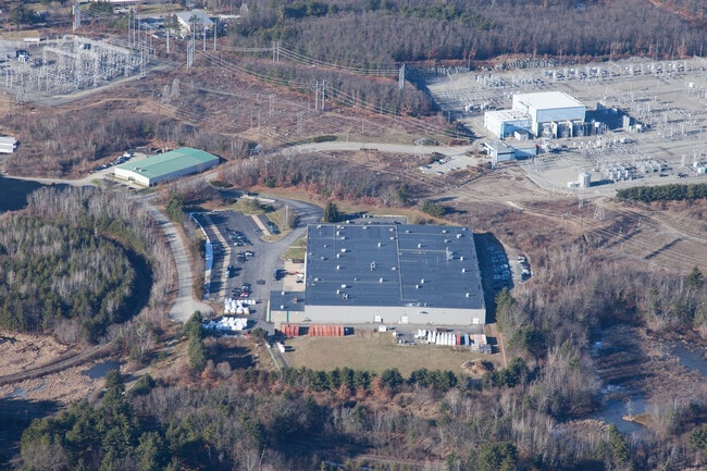
Property Record
90 Nemco Way, Ayer, MA 01432


Save to a Folder
{{folder.Name}}
{{folder.ListingIds.length}} Properties
{{folder.ListingIds.length}} Property
Create a New Folder
Property Detail
90 Nemco Way
AYER-000008-000000-000014
Middlesex
Manufacturinglight
Massachusetts
I
14
B and X Area of moderate flood hazard, usually the area between the limits of the 100-year and 500-year floods.
22.71 AC
2025
Concord/Maynard
2025
Boston
325101
Boston-Cambridge-Newton, MA-NH
213,950 SF
NEARBY LISTINGS FOR SALE OR LEASE
DEMOGRAPHICS near 90 Nemco Way
1 mile
3 mile
5 mile
2025 Total Population
2,090
19,241
43,521
2030 Population
2,203
20,169
45,363
Pop Growth 2025-2030
+ 5.41%
+ 4.82%
+ 4.23%
Average Age
42
42
42
2025 Total Households
778
7,413
16,076
HH Growth 2025-2030
+ 5.66%
+ 5.00%
+ 4.44%
Median Household Inc
$170,876
$147,964
$149,768
Avg Household Size
2.70
2.60
2.60
2025 Avg HH Vehicles
2.00
2.00
2.00
Median Home Value
$652,573
$644,346
$678,088
Median Year Built
1989
1981
1980
Nearby Places
Map Layers
Map Styles
 Street
 Aerial
Layers
 Traffic
 Biking
Places
Listings with unknown addresses are not visible on the map
- Restaurants
- Banks
- Shops
- Fitness
- Groceries
PUBLIC TRANSPORTATION
COMMUTER RAIL
Ayer (Fitchburg/South Acton Line - Massachusetts Bay Transportation Authority Commuter Rail (Purple Line))
Drive
Walk
Distance
Ayer (Fitchburg/South Acton Line - Massachusetts Bay Transportation Authority Commuter Rail (Purple Line))
11 min
3.8 mi
Littleton/Route 495 (Fitchburg/South Acton Line - Massachusetts Bay Transportation Authority Commuter Rail (Purple Line))
Drive
Walk
Distance
Littleton/Route 495 (Fitchburg/South Acton Line - Massachusetts Bay Transportation Authority Commuter Rail (Purple Line))
13 min
5.7 mi
AIRPORT
Manchester Boston Regional
Drive
Walk
Distance
Manchester Boston Regional
56 min
33.9 mi
General Edward Lawrence Logan International
Drive
Walk
Distance
General Edward Lawrence Logan International
60 min
36.4 mi
Worcester Regional
Drive
Walk
Distance
Worcester Regional
54 min
36.9 mi
Freight Ports
Port of Boston
Drive
Walk
Distance
Port of Boston
60 min
36.4 mi
SALE & LEASE HISTORY
LISTING DATE
SALE/LEASE

Nov 14, 2022
For Lease
Nearby Properties
Address
Land Use
TOTAL SIZE
Lot Size
Zoning
Address
Land Use
TOTAL SIZE
Lot Size
Zoning
329,818 SF
55 AC
A1
Address
Land Use
TOTAL SIZE
Lot Size
Zoning
448,759 SF
51.82 AC
IA
Address
Land Use
TOTAL SIZE
Lot Size
Zoning
481,300 SF
69.04 AC
IA
Address
Land Use
TOTAL SIZE
Lot Size
Zoning
54.50 AC
R
Address
Land Use
TOTAL SIZE
Lot Size
Zoning
171,661 SF
5.46 AC
IB
Address
Land Use
TOTAL SIZE
Lot Size
Zoning
51,888 SF
57.38 AC
LI
Address
Land Use
TOTAL SIZE
Lot Size
Zoning
39.84 AC
B
Address
Land Use
TOTAL SIZE
Lot Size
Zoning
374,270 SF
62.74 AC
IA
Address
Land Use
TOTAL SIZE
Lot Size
Zoning
125,160 SF
29.36 AC
R
Address
Land Use
TOTAL SIZE
Lot Size
Zoning
109,556 SF
85.62 AC
RA
Address
Land Use
TOTAL SIZE
Lot Size
Zoning
125,642 SF
5.77 AC
IB
Address
Land Use
TOTAL SIZE
Lot Size
Zoning
293,250 SF
60.10 AC
LI
Address
Land Use
TOTAL SIZE
Lot Size
Zoning
343,400 SF
20 AC
LI
Address
Land Use
TOTAL SIZE
Lot Size
Zoning
105,559 SF
35.45 AC
A1
Address
Land Use
TOTAL SIZE
Lot Size
Zoning
16.44 AC
IA
Address
Land Use
TOTAL SIZE
Lot Size
Zoning
134,920 SF
26.90 AC
I
Address
Land Use
TOTAL SIZE
Lot Size
Zoning
8.21 AC
R
Address
Land Use
TOTAL SIZE
Lot Size
Zoning
63,420 SF
40.10 AC
RA
Address
Land Use
TOTAL SIZE
Lot Size
Zoning
65,680 SF
7.59 AC
IA
Address
Land Use
TOTAL SIZE
Lot Size
Zoning
672 SF
183.18 AC
IA
Address
Land Use
TOTAL SIZE
Lot Size
Zoning
44,417 SF
2.29 AC
RA
Address
Land Use
TOTAL SIZE
Lot Size
Zoning
94,159 SF
13.31 AC
I
Address
Land Use
TOTAL SIZE
Lot Size
Zoning
16.22 AC
IA
Address
Land Use
TOTAL SIZE
Lot Size
Zoning
57,152 SF
20.30 AC
A2
Address
Land Use
TOTAL SIZE
Lot Size
Zoning
58,738 SF
183.84 AC
RA
Address
Land Use
TOTAL SIZE
Lot Size
Zoning
161,597 SF
20.67 AC
IA
Address
Land Use
TOTAL SIZE
Lot Size
Zoning
62,860 SF
9.97 AC
IA
Address
Land Use
TOTAL SIZE
Lot Size
Zoning
49,689 SF
3.67 AC
GB
Address
Land Use
TOTAL SIZE
Lot Size
Zoning
160,860 SF
5.81 AC
I
The World's #1 Commercial Real Estate Marketplace
Connect with us
© 2026 CoStar Group
The information above has been obtained from sources believed reliable. While we do not doubt its accuracy we have not verified it and make no guarantee, warranty or representation about it. It is your responsibility to independently confirm its accuracy and completeness. Any projections, opinions, assumptions, or estimates used are for example only and do not represent the current or future performance of the property. The value of this transaction to you depends on tax and other factors which should be evaluated by your tax, financial, and legal advisors. You and your advisors should conduct a careful, independent investigation of the property to determine to your satisfaction the suitability of the property for your needs.