Property Record
950 S Cimarron Way, Aurora, CO 80012

NEARBY LISTINGS FOR SALE OR LEASE
Property Detail
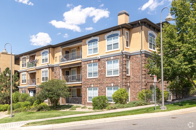
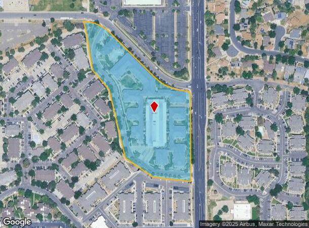
950 S Cimarron Way
Denver-Aurora-Centennial, CO
The Retreat At City Center Sub 1St Flg
1975-18-3-22-001
SUBDIVISIONCD 051730 SUBDIVISIONNAME THE RETREAT AT CITY CENTER SUB 1ST FLG BLOCK 001 LOT 001 LOT 1 BLK 1 THE RETREAT AT CITY CENTER SUB 1ST FLG
Apartment
Arapahoe
X
Colorado
08005C0179L
1
2024
7.21 AC
2025
City Center
081101
Denver
348,019 SF
DEMOGRAPHICS near 950 S Cimarron Way
1 mile
3 mile
5 mile
2024 Total Population
21,932
180,160
406,187
2029 Population
22,159
181,221
410,744
Pop Growth 2024-2029
+ 1.04%
+ 0.59%
+ 1.12%
Average Age
35
38
38
2024 Total Households
8,592
68,961
158,759
HH Growth 2024-2029
+ 1.20%
+ 0.62%
+ 1.15%
Median Household Inc
$59,826
$62,010
$65,733
Avg Household Size
2.50
2.50
2.50
2024 Avg HH Vehicles
2.00
2.00
2.00
Median Home Value
$319,286
$359,985
$382,426
Median Year Built
1982
1981
1982
Nearby Places
Map Layers
Map Styles
 Street
 Aerial
Transit
 Traffic
 Biking
Places
Listings with unknown addresses are not visible on the map
- Restaurants
- Banks
- Shops
- Fitness
- Groceries
PUBLIC TRANSPORTATION
COMMUTER RAIL
Drive
Walk
Distance
12 min
7.1 mi
Drive
Walk
Distance
12 min
7.2 mi
AIRPORT
Denver International
Drive
Walk
Distance
Denver International
25 min
18.9 mi
Nearby Properties
Address
Land Use
TOTAL SIZE
Lot Size
Zoning
Address
Land Use
TOTAL SIZE
Lot Size
Zoning
116,490 SF
3.71 AC
PUD
Address
Land Use
TOTAL SIZE
Lot Size
Zoning
140,419 SF
8.37 AC
Address
Land Use
TOTAL SIZE
Lot Size
Zoning
161,437 SF
2.22 AC
RCZDC
Address
Land Use
TOTAL SIZE
Lot Size
Zoning
97,001 SF
Address
Land Use
TOTAL SIZE
Lot Size
Zoning
496,493 SF
33.45 AC
Address
Land Use
TOTAL SIZE
Lot Size
Zoning
87,346 SF
1.76 AC
RFBAD
Address
Land Use
TOTAL SIZE
Lot Size
Zoning
87,207 SF
Address
Land Use
TOTAL SIZE
Lot Size
Zoning
201,600 SF
44.67 AC
R1
Address
Land Use
TOTAL SIZE
Lot Size
Zoning
313,993 SF
5.69 AC
Address
Land Use
TOTAL SIZE
Lot Size
Zoning
476,186 SF
42.62 AC
Address
Land Use
TOTAL SIZE
Lot Size
Zoning
140.42 AC
Address
Land Use
TOTAL SIZE
Lot Size
Zoning
277,940 SF
31.61 AC
Address
Land Use
TOTAL SIZE
Lot Size
Zoning
557,843 SF
21.35 AC
PUD
Address
Land Use
TOTAL SIZE
Lot Size
Zoning
83,951 SF
0.30 AC
R2
Address
Land Use
TOTAL SIZE
Lot Size
Zoning
315,058 SF
36.85 AC
RPCZD
Address
Land Use
TOTAL SIZE
Lot Size
Zoning
47,616 SF
140.42 AC
PUD
Address
Land Use
TOTAL SIZE
Lot Size
Zoning
43,568 SF
1.53 AC
Address
Land Use
TOTAL SIZE
Lot Size
Zoning
50,106 SF
1.67 AC
RB1
Address
Land Use
TOTAL SIZE
Lot Size
Zoning
277,985 SF
19.07 AC
Address
Land Use
TOTAL SIZE
Lot Size
Zoning
55,662 SF
3.71 AC
Address
Land Use
TOTAL SIZE
Lot Size
Zoning
178,235 SF
1.38 AC
RFBAD
Address
Land Use
TOTAL SIZE
Lot Size
Zoning
624,019 SF
4.09 AC
Address
Land Use
TOTAL SIZE
Lot Size
Zoning
672,521 SF
0.61 AC
RB3
Address
Land Use
TOTAL SIZE
Lot Size
Zoning
176,751 SF
28.75 AC
Address
Land Use
TOTAL SIZE
Lot Size
Zoning
366,800 SF
20.21 AC
Address
Land Use
TOTAL SIZE
Lot Size
Zoning
130,531 SF
3.41 AC
Address
Land Use
TOTAL SIZE
Lot Size
Zoning
540,166 SF
2.80 AC
Address
Land Use
TOTAL SIZE
Lot Size
Zoning
540,380 SF
26.03 AC
RR3
The World's #1 Commercial Real Estate Marketplace
Connect with us
© 2026 CoStar Group
The information above has been obtained from sources believed reliable. While we do not doubt its accuracy we have not verified it and make no guarantee, warranty or representation about it. It is your responsibility to independently confirm its accuracy and completeness. Any projections, opinions, assumptions, or estimates used are for example only and do not represent the current or future performance of the property. The value of this transaction to you depends on tax and other factors which should be evaluated by your tax, financial, and legal advisors. You and your advisors should conduct a careful, independent investigation of the property to determine to your satisfaction the suitability of the property for your needs.