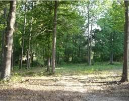
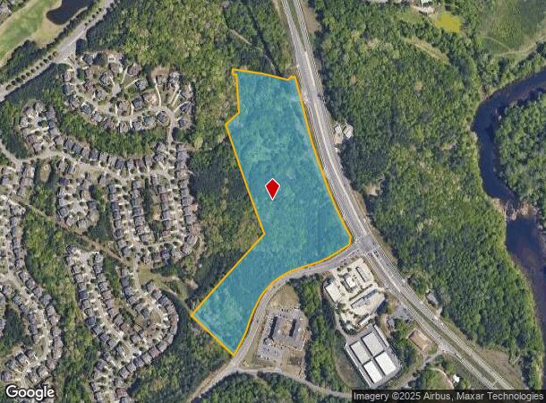
Property Record
0 James Burgess Rd, Cumming, GA 30041
NEARBY LISTINGS FOR SALE OR LEASE
Property Detail
0 James Burgess Rd
Atlanta-Sandy Springs-Roswell, GA
Colliers Cauble & Co
229-049
2-1 56 ETAL
Commercialnec
Forsyth
X
Georgia
13139C0275G
720
2024
23.91 AC
2025
N Fulton/Forsyth County
130509
Atlanta
DEMOGRAPHICS near 0 James Burgess Rd
1 Mile
3 Mile
5 Mile
2024 Total Population
3,507
53,232
130,536
2029 Population
3,989
59,390
145,376
Pop Growth 2024-2029
+ 13.74%
+ 11.57%
+ 11.37%
Average Age
37
37
38
2024 Total Households
1,161
16,373
41,921
HH Growth 2024-2029
+ 13.70%
+ 11.54%
+ 11.48%
Median Household Inc
$180,116
$137,379
$125,607
Avg Household Size
3.00
3.20
3.10
2024 Avg HH Vehicles
2.00
2.00
2.00
Median Home Value
$689,781
$452,796
$446,617
Median Year Built
2004
2003
2002
Nearby Places
- Restaurants
- Banks
- Shops
- Fitness
- Groceries
Nearby Properties
Address
Land Use
TOTAL SIZE
Lot Size
Zoning
Address
Land Use
TOTAL SIZE
Lot Size
Zoning
424,176 SF
59.62 AC
R3
Address
Land Use
TOTAL SIZE
Lot Size
Zoning
29,763 SF
20.36 AC
MP
Address
Land Use
TOTAL SIZE
Lot Size
Zoning
244,214 SF
7.50 AC
OI
Address
Land Use
TOTAL SIZE
Lot Size
Zoning
99,600 SF
91.27 AC
CR1
Address
Land Use
TOTAL SIZE
Lot Size
Zoning
291,232 SF
71.66 AC
RES3
Address
Land Use
TOTAL SIZE
Lot Size
Zoning
408 SF
217.12 AC
R100
Address
Land Use
TOTAL SIZE
Lot Size
Zoning
132,721 SF
51.36 AC
OI
Address
Land Use
TOTAL SIZE
Lot Size
Zoning
186,015 SF
13.72 AC
MP
Address
Land Use
TOTAL SIZE
Lot Size
Zoning
115,555 SF
34.65 AC
R100MOD
Address
Land Use
TOTAL SIZE
Lot Size
Zoning
290,701 SF
70.48 AC
A1
Address
Land Use
TOTAL SIZE
Lot Size
Zoning
1,600 SF
85.02 AC
RES3
Address
Land Use
TOTAL SIZE
Lot Size
Zoning
15,920 SF
9.49 AC
CBD
Address
Land Use
TOTAL SIZE
Lot Size
Zoning
24,396 SF
72.23 AC
A1
Address
Land Use
TOTAL SIZE
Lot Size
Zoning
3,366 SF
20.07 AC
PUD
Address
Land Use
TOTAL SIZE
Lot Size
Zoning
98,471 SF
10.86 AC
BG
Address
Land Use
TOTAL SIZE
Lot Size
Zoning
98,593 SF
34.52 AC
R2R
Address
Land Use
TOTAL SIZE
Lot Size
Zoning
46,791 SF
4.04 AC
BG
Address
Land Use
TOTAL SIZE
Lot Size
Zoning
91,163 SF
9.06 AC
CBD
Address
Land Use
TOTAL SIZE
Lot Size
Zoning
64,432 SF
4.97 AC
CBD
Address
Land Use
TOTAL SIZE
Lot Size
Zoning
93,600 SF
1.79 AC
BG
Address
Land Use
TOTAL SIZE
Lot Size
Zoning
297.44 AC
AF
Address
Land Use
TOTAL SIZE
Lot Size
Zoning
143,835 SF
34.80 AC
A1
Address
Land Use
TOTAL SIZE
Lot Size
Zoning
3,706 SF
21.17 AC
HB
Address
Land Use
TOTAL SIZE
Lot Size
Zoning
33,033 SF
7.62 AC
BG
Address
Land Use
TOTAL SIZE
Lot Size
Zoning
75,576 SF
8.79 AC
CBD
Address
Land Use
TOTAL SIZE
Lot Size
Zoning
962 SF
22.24 AC
OI
Address
Land Use
TOTAL SIZE
Lot Size
Zoning
93.60 AC
A1
Address
Land Use
TOTAL SIZE
Lot Size
Zoning
80,309 SF
10.47 AC
BG2
Address
Land Use
TOTAL SIZE
Lot Size
Zoning
1,120 SF
99.05 AC
HM2
Address
Land Use
TOTAL SIZE
Lot Size
Zoning
49,774 SF
10.61 AC
MP
The World's #1 Commercial Real Estate Marketplace
Connect with us
© 2025 CoStar Group
The information above has been obtained from sources believed reliable. While we do not doubt its accuracy we have not verified it and make no guarantee, warranty or representation about it. It is your responsibility to independently confirm its accuracy and completeness. Any projections, opinions, assumptions, or estimates used are for example only and do not represent the current or future performance of the property. The value of this transaction to you depends on tax and other factors which should be evaluated by your tax, financial, and legal advisors. You and your advisors should conduct a careful, independent investigation of the property to determine to your satisfaction the suitability of the property for your needs.