Property Record
Trietsch Rd, Carrollton, TX 75007

Property Detail
Trietsch Rd
Dallas-Fort Worth-Arlington, TX
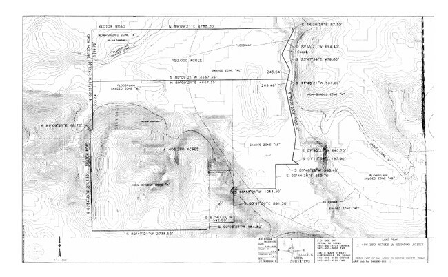
A0355A DOWNING, TR 1, 160. ACRES
R56959
DENTON
Agriculturalland
Texas
B and X Area of moderate flood hazard, usually the area between the limits of the 100-year and 500-year floods.
160 AC
2024
Denton
2025
Dallas/Ft Worth
021614
NEARBY LISTINGS FOR SALE OR LEASE
-
-
View all Carrollton listings for sale on LoopNet.com
DEMOGRAPHICS near Trietsch Rd
1 mile
3 mile
5 mile
2025 Total Population
82
2,243
36,009
2030 Population
93
2,565
41,073
Pop Growth 2025-2030
+ 13.41%
+ 14.36%
+ 14.06%
Average Age
37
37
38
2025 Total Households
30
808
13,446
HH Growth 2025-2030
+ 13.33%
+ 14.60%
+ 14.20%
Median Household Inc
$93,749
$97,859
$87,716
Avg Household Size
2.70
2.70
2.60
2025 Avg HH Vehicles
2.00
2.00
2.00
Median Home Value
$340,909
$346,745
$333,340
Median Year Built
2010
2006
2000
Nearby Places
Map Layers
Map Styles
 Street
 Aerial
Transit
 Traffic
 Biking
Places
Listings with unknown addresses are not visible on the map
- Restaurants
- Banks
- Shops
- Fitness
- Groceries
PUBLIC TRANSPORTATION
COMMUTER RAIL
Downtown Denton Transit Center (A-train - Denton County Transportation Authority)
Drive
Walk
Distance
Downtown Denton Transit Center (A-train - Denton County Transportation Authority)
21 min
9.2 mi
Freight Ports
Tulsa Port of Inola
Drive
Walk
Distance
Tulsa Port of Inola
306 min
266.6 mi
Nearby Properties
Address
Land Use
TOTAL SIZE
Lot Size
Zoning
Address
Land Use
TOTAL SIZE
Lot Size
Zoning
1,094 SF
104.42 AC
Address
Land Use
TOTAL SIZE
Lot Size
Zoning
81,684 SF
13.35 AC
Address
Land Use
TOTAL SIZE
Lot Size
Zoning
75.95 AC
Address
Land Use
TOTAL SIZE
Lot Size
Zoning
102.50 AC
Address
Land Use
TOTAL SIZE
Lot Size
Zoning
66.67 AC
Address
Land Use
TOTAL SIZE
Lot Size
Zoning
1,153,213 SF
81.58 AC
Address
Land Use
TOTAL SIZE
Lot Size
Zoning
45.51 AC
Address
Land Use
TOTAL SIZE
Lot Size
Zoning
48,064 SF
4.34 AC
Address
Land Use
TOTAL SIZE
Lot Size
Zoning
48,977 SF
33.20 AC
Address
Land Use
TOTAL SIZE
Lot Size
Zoning
109,416 SF
10.77 AC
Address
Land Use
TOTAL SIZE
Lot Size
Zoning
35,000 SF
3.35 AC
Address
Land Use
TOTAL SIZE
Lot Size
Zoning
63.99 AC
Address
Land Use
TOTAL SIZE
Lot Size
Zoning
90,800 SF
4.45 AC
Address
Land Use
TOTAL SIZE
Lot Size
Zoning
15,230 SF
40 AC
Address
Land Use
TOTAL SIZE
Lot Size
Zoning
1,217 SF
31.24 AC
Address
Land Use
TOTAL SIZE
Lot Size
Zoning
2,475 SF
112.83 AC
Address
Land Use
TOTAL SIZE
Lot Size
Zoning
3,050 SF
42.34 AC
Address
Land Use
TOTAL SIZE
Lot Size
Zoning
8,011 SF
247.32 AC
Address
Land Use
TOTAL SIZE
Lot Size
Zoning
23.88 AC
Address
Land Use
TOTAL SIZE
Lot Size
Zoning
20.09 AC
Address
Land Use
TOTAL SIZE
Lot Size
Zoning
11,120 SF
3.86 AC
Address
Land Use
TOTAL SIZE
Lot Size
Zoning
85.17 AC
Address
Land Use
TOTAL SIZE
Lot Size
Zoning
2,949 SF
13.81 AC
Address
Land Use
TOTAL SIZE
Lot Size
Zoning
4,930 SF
48.51 AC
Address
Land Use
TOTAL SIZE
Lot Size
Zoning
500 SF
27.23 AC
Address
Land Use
TOTAL SIZE
Lot Size
Zoning
1,560 SF
18.18 AC
Address
Land Use
TOTAL SIZE
Lot Size
Zoning
5,489 SF
18.32 AC
Address
Land Use
TOTAL SIZE
Lot Size
Zoning
4,920 SF
19.99 AC
Address
Land Use
TOTAL SIZE
Lot Size
Zoning
11,130 SF
3 AC
Address
Land Use
TOTAL SIZE
Lot Size
Zoning
16.40 AC
The World's #1 Commercial Real Estate Marketplace
Connect with us
© 2026 CoStar Group
The information above has been obtained from sources believed reliable. While we do not doubt its accuracy we have not verified it and make no guarantee, warranty or representation about it. It is your responsibility to independently confirm its accuracy and completeness. Any projections, opinions, assumptions, or estimates used are for example only and do not represent the current or future performance of the property. The value of this transaction to you depends on tax and other factors which should be evaluated by your tax, financial, and legal advisors. You and your advisors should conduct a careful, independent investigation of the property to determine to your satisfaction the suitability of the property for your needs.