Property Record
12131 E Iliff Ave, Aurora, CO 80014
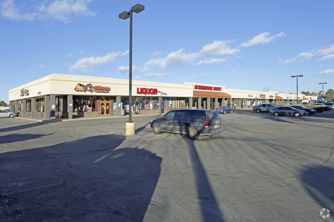


Property Detail
12131 E Iliff Ave
1973-25-2-02-001
SUBDIVISIONCD 035795 SUBDIVISIONNAME ILIFF MEADOWS CENTER SUB 1ST FLG BLOCK 001 LOT 001 LOT 1 BLK 1 ILIFF MEADOWS CENTER SUB 1ST FLG
Storebuilding
Arapahoe
PUD
Colorado
B and X Area of moderate flood hazard, usually the area between the limits of the 100-year and 500-year floods.
001
2024
6.99 AC
2025
Aurora
080600
Denver
79,721 SF
Denver-Aurora-Centennial, CO
NEARBY LISTINGS FOR SALE OR LEASE
DEMOGRAPHICS near 12131 E Iliff Ave
1 mile
3 mile
5 mile
2025 Total Population
20,274
176,939
464,754
2030 Population
20,520
180,458
473,584
Pop Growth 2025-2030
+ 1.21%
+ 1.99%
+ 1.90%
Average Age
42
39
39
2025 Total Households
8,420
75,393
190,688
HH Growth 2025-2030
+ 1.25%
+ 2.09%
+ 2.05%
Median Household Inc
$84,287
$73,746
$79,550
Avg Household Size
2.30
2.30
2.30
2025 Avg HH Vehicles
2.00
2.00
2.00
Median Home Value
$461,635
$430,466
$476,203
Median Year Built
1978
1981
1981
Nearby Places
Map Layers
Map Styles
 Street
 Aerial
Transit
 Traffic
 Biking
Places
Listings with unknown addresses are not visible on the map
- Restaurants
- Banks
- Shops
- Fitness
- Groceries
PUBLIC TRANSPORTATION
COMMUTER RAIL
Drive
Walk
Distance
19 min
8.9 mi
Drive
Walk
Distance
15 min
9.6 mi
AIRPORT
Denver International
Drive
Walk
Distance
Denver International
28 min
21.4 mi
SALE & LEASE HISTORY
LISTING DATE
SALE/LEASE

Sep 25, 2016
For Lease
Oct 06, 2016
For Lease
Nov 24, 2020
For Lease
Nearby Properties
Address
Land Use
TOTAL SIZE
Lot Size
Zoning
Address
Land Use
TOTAL SIZE
Lot Size
Zoning
163,033 SF
5.94 AC
PUD
Address
Land Use
TOTAL SIZE
Lot Size
Zoning
496,493 SF
33.45 AC
Address
Land Use
TOTAL SIZE
Lot Size
Zoning
87,207 SF
Address
Land Use
TOTAL SIZE
Lot Size
Zoning
201,600 SF
44.67 AC
R1
Address
Land Use
TOTAL SIZE
Lot Size
Zoning
313,993 SF
5.69 AC
Address
Land Use
TOTAL SIZE
Lot Size
Zoning
476,186 SF
42.62 AC
Address
Land Use
TOTAL SIZE
Lot Size
Zoning
70,296 SF
4.96 AC
Address
Land Use
TOTAL SIZE
Lot Size
Zoning
74,888 SF
4.35 AC
AMU
Address
Land Use
TOTAL SIZE
Lot Size
Zoning
557,843 SF
21.35 AC
PUD
Address
Land Use
TOTAL SIZE
Lot Size
Zoning
83,951 SF
0.30 AC
R2
Address
Land Use
TOTAL SIZE
Lot Size
Zoning
315,058 SF
36.85 AC
RPCZD
Address
Land Use
TOTAL SIZE
Lot Size
Zoning
50,106 SF
1.67 AC
RB1
Address
Land Use
TOTAL SIZE
Lot Size
Zoning
613,600 SF
29.40 AC
R-3
Address
Land Use
TOTAL SIZE
Lot Size
Zoning
277,985 SF
19.07 AC
Address
Land Use
TOTAL SIZE
Lot Size
Zoning
130,531 SF
3.41 AC
Address
Land Use
TOTAL SIZE
Lot Size
Zoning
478,994 SF
26.07 AC
Address
Land Use
TOTAL SIZE
Lot Size
Zoning
48,961 SF
4.15 AC
Address
Land Use
TOTAL SIZE
Lot Size
Zoning
138,750 SF
12.17 AC
OS-A
Address
Land Use
TOTAL SIZE
Lot Size
Zoning
540,380 SF
26.03 AC
RR3
Address
Land Use
TOTAL SIZE
Lot Size
Zoning
49,627 SF
4.18 AC
B-2
Address
Land Use
TOTAL SIZE
Lot Size
Zoning
209,690 SF
7.21 AC
S-SU-D
Address
Land Use
TOTAL SIZE
Lot Size
Zoning
383,436 SF
9.77 AC
Address
Land Use
TOTAL SIZE
Lot Size
Zoning
78,876 SF
0.05 AC
C-MX
Address
Land Use
TOTAL SIZE
Lot Size
Zoning
521,364 SF
14.88 AC
PUD
Address
Land Use
TOTAL SIZE
Lot Size
Zoning
506,272 SF
20.38 AC
PUD
Address
Land Use
TOTAL SIZE
Lot Size
Zoning
333,696 SF
17.52 AC
PUD
Address
Land Use
TOTAL SIZE
Lot Size
Zoning
1,344,255 SF
15.88 AC
AMU
Address
Land Use
TOTAL SIZE
Lot Size
Zoning
462,048 SF
5.34 AC
RB3
Address
Land Use
TOTAL SIZE
Lot Size
Zoning
105,809 SF
48.79 AC
Address
Land Use
TOTAL SIZE
Lot Size
Zoning
649,712 SF
47.31 AC
The World's #1 Commercial Real Estate Marketplace
Connect with us
© 2026 CoStar Group
The information above has been obtained from sources believed reliable. While we do not doubt its accuracy we have not verified it and make no guarantee, warranty or representation about it. It is your responsibility to independently confirm its accuracy and completeness. Any projections, opinions, assumptions, or estimates used are for example only and do not represent the current or future performance of the property. The value of this transaction to you depends on tax and other factors which should be evaluated by your tax, financial, and legal advisors. You and your advisors should conduct a careful, independent investigation of the property to determine to your satisfaction the suitability of the property for your needs.