Property Record
1335 W 15Th St, Long Beach, CA 90813
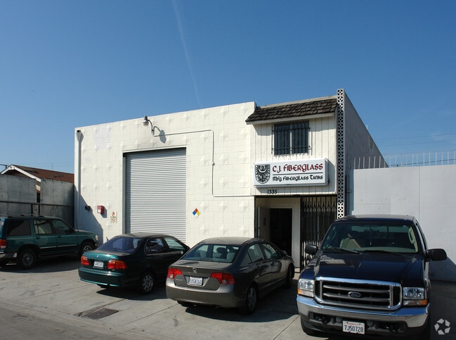


This Property Is For Sale
Property Detail
1335 W 15Th St
7432-021-022
INNER HARBOR TRACT LOT 17 BLK 27
Lightindustrial
Los Angeles
LBIG
California
A Areas with a 1% annual chance of flooding and a 26% chance of flooding over the life of a 30-year mortgage.
17
2025
0.11 AC
2025
Long Beach
980011
Los Angeles
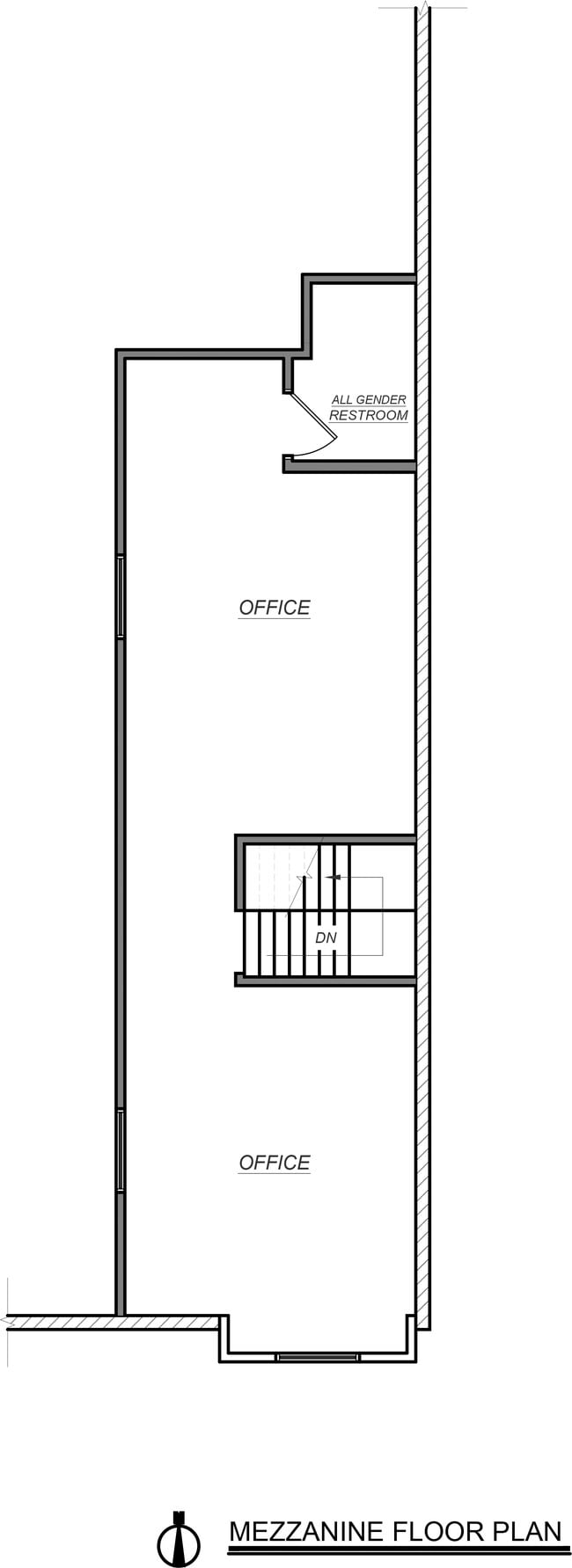
4,320 SF
Los Angeles-Long Beach-Glendale, CA
NEARBY LISTINGS FOR SALE OR LEASE
DEMOGRAPHICS near 1335 W 15Th St
1 mile
3 mile
5 mile
2025 Total Population
26,863
216,613
448,445
2030 Population
26,588
215,333
444,474
Pop Growth 2025-2030
(1.02%)
(0.59%)
(0.89%)
Average Age
37
38
39
2025 Total Households
8,181
77,685
157,781
HH Growth 2025-2030
(1.22%)
(0.46%)
(0.92%)
Median Household Inc
$56,444
$70,138
$81,097
Avg Household Size
3.00
2.60
2.70
2025 Avg HH Vehicles
2.00
2.00
2.00
Median Home Value
$692,735
$703,539
$743,810
Median Year Built
1957
1962
1961
Nearby Places
Map Layers
Map Styles
 Street
 Aerial
Layers
 Traffic
 Biking
Places
Listings with unknown addresses are not visible on the map
- Restaurants
- Banks
- Shops
- Fitness
- Groceries
PUBLIC TRANSPORTATION
AIRPORT
Long Beach (Daugherty Field)
Drive
Walk
Distance
Long Beach (Daugherty Field)
11 min
6.3 mi
Los Angeles International
Drive
Walk
Distance
Los Angeles International
30 min
20.7 mi
John Wayne/Orange County
Drive
Walk
Distance
John Wayne/Orange County
34 min
26.5 mi
Freight Ports
Port of Long Beach
Drive
Walk
Distance
Port of Long Beach
7 min
3.0 mi
Nearby Properties
Address
Land Use
TOTAL SIZE
Lot Size
Zoning
Address
Land Use
TOTAL SIZE
Lot Size
Zoning
502,333 SF
21.89 AC
LBI
Address
Land Use
TOTAL SIZE
Lot Size
Zoning
236,582 SF
425.41 AC
CAMH*
Address
Land Use
TOTAL SIZE
Lot Size
Zoning
402,342 SF
LBPD30
Address
Land Use
TOTAL SIZE
Lot Size
Zoning
845,760 SF
4.01 AC
LBPD6
Address
Land Use
TOTAL SIZE
Lot Size
Zoning
708,409 SF
3.15 AC
LBPD
Address
Land Use
TOTAL SIZE
Lot Size
Zoning
266,158 SF
1 AC
LBPD30
Address
Land Use
TOTAL SIZE
Lot Size
Zoning
617,114 SF
3.53 AC
LBPD
Address
Land Use
TOTAL SIZE
Lot Size
Zoning
918,344 SF
4.14 AC
LBPD30
Address
Land Use
TOTAL SIZE
Lot Size
Zoning
56,300 SF
116.80 AC
LAM3
Address
Land Use
TOTAL SIZE
Lot Size
Zoning
260,804 SF
1.71 AC
LBPD30
Address
Land Use
TOTAL SIZE
Lot Size
Zoning
982,195 SF
1.77 AC
LBPD30
Address
Land Use
TOTAL SIZE
Lot Size
Zoning
182,749 SF
LBPD30
Address
Land Use
TOTAL SIZE
Lot Size
Zoning
286,186 SF
8.20 AC
LAMR1
Address
Land Use
TOTAL SIZE
Lot Size
Zoning
393,161 SF
1.11 AC
LBPD30
Address
Land Use
TOTAL SIZE
Lot Size
Zoning
372,367 SF
2.40 AC
LBPD30
Address
Land Use
TOTAL SIZE
Lot Size
Zoning
108,891 SF
224.14 AC
CAMH*
Address
Land Use
TOTAL SIZE
Lot Size
Zoning
119,356 SF
3.86 AC
LAM2
Address
Land Use
TOTAL SIZE
Lot Size
Zoning
174,688 SF
0.88 AC
LBI*
Address
Land Use
TOTAL SIZE
Lot Size
Zoning
285,314 SF
14.28 AC
CAMH*
Address
Land Use
TOTAL SIZE
Lot Size
Zoning
513,520 SF
19.09 AC
LBPD26
Address
Land Use
TOTAL SIZE
Lot Size
Zoning
311,796 SF
1.90 AC
LBPD30
Address
Land Use
TOTAL SIZE
Lot Size
Zoning
133,668 SF
0.76 AC
LBCH
Address
Land Use
TOTAL SIZE
Lot Size
Zoning
113,919 SF
0.72 AC
LBPD30
Address
Land Use
TOTAL SIZE
Lot Size
Zoning
194,230 SF
2.58 AC
LBR4N
Address
Land Use
TOTAL SIZE
Lot Size
Zoning
9,629 SF
2.37 AC
LBPD30
Address
Land Use
TOTAL SIZE
Lot Size
Zoning
1,800 SF
124.45 AC
CAMH*
Address
Land Use
TOTAL SIZE
Lot Size
Zoning
213,408 SF
13.81 AC
LBR4R
Address
Land Use
TOTAL SIZE
Lot Size
Zoning
279,022 SF
1.80 AC
LBCB
Address
Land Use
TOTAL SIZE
Lot Size
Zoning
135,666 SF
LAM3
Address
Land Use
TOTAL SIZE
Lot Size
Zoning
14.80 AC
CAMH*
The World's #1 Commercial Real Estate Marketplace
Connect with us
© 2026 CoStar Group
The information above has been obtained from sources believed reliable. While we do not doubt its accuracy we have not verified it and make no guarantee, warranty or representation about it. It is your responsibility to independently confirm its accuracy and completeness. Any projections, opinions, assumptions, or estimates used are for example only and do not represent the current or future performance of the property. The value of this transaction to you depends on tax and other factors which should be evaluated by your tax, financial, and legal advisors. You and your advisors should conduct a careful, independent investigation of the property to determine to your satisfaction the suitability of the property for your needs.