Property Record
14466 Main St, Hesperia, CA 92345


Save to a Folder
{{folder.Name}}
{{folder.ListingIds.length}} Properties
{{folder.ListingIds.length}} Property
Create a New Folder
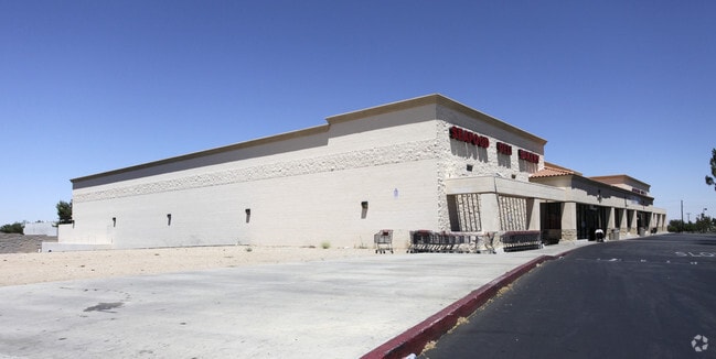
Property Detail
14466 Main St
0405-271-37
PARCEL MAP 12373 PARCEL 3 BOOK 168 PAGE 48 PARCEL MAP 12373 PARCEL NO 3 ***** 5-19-94 #94-229187 OD *****
Supermarket
San Bernardino
B and X Area of moderate flood hazard, usually the area between the limits of the 100-year and 500-year floods.
California
2025
4.06 AC
2026
Mojave River Valley
010016
Inland Empire (California)
41,640 SF
Riverside-San Bernardino-Ontario, CA
NEARBY LISTINGS FOR SALE OR LEASE
DEMOGRAPHICS near 14466 Main St
1 mile
3 mile
5 mile
2025 Total Population
10,125
57,303
153,333
2030 Population
10,350
58,537
156,178
Pop Growth 2025-2030
+ 2.22%
+ 2.15%
+ 1.86%
Average Age
35
36
36
2025 Total Households
2,825
16,175
44,118
HH Growth 2025-2030
+ 2.27%
+ 2.15%
+ 1.82%
Median Household Inc
$86,802
$80,054
$78,343
Avg Household Size
3.50
3.50
3.40
2025 Avg HH Vehicles
2.00
2.00
2.00
Median Home Value
$388,455
$413,715
$405,648
Median Year Built
1996
1993
1991
Nearby Places
Map Layers
Map Styles
 Street
 Aerial
Layers
 Traffic
 Biking
Places
Listings with unknown addresses are not visible on the map
- Restaurants
- Banks
- Shops
- Fitness
- Groceries
PUBLIC TRANSPORTATION
COMMUTER RAIL
Drive
Walk
Distance
15 min
9.8 mi
AIRPORT
Ontario International
Drive
Walk
Distance
Ontario International
47 min
38.7 mi
Freight Ports
Port of Long Beach
Drive
Walk
Distance
Port of Long Beach
108 min
90.8 mi
SALE & LEASE HISTORY
LISTING DATE
SALE/LEASE

Jan 04, 2024
For Lease
Nearby Properties
Address
Land Use
TOTAL SIZE
Lot Size
Zoning
Address
Land Use
TOTAL SIZE
Lot Size
Zoning
213,482 SF
19.98 AC
Address
Land Use
TOTAL SIZE
Lot Size
Zoning
315,603 SF
48.21 AC
Address
Land Use
TOTAL SIZE
Lot Size
Zoning
54,994 SF
9.12 AC
Address
Land Use
TOTAL SIZE
Lot Size
Zoning
616,817 SF
31.82 AC
Address
Land Use
TOTAL SIZE
Lot Size
Zoning
399,430 SF
17.57 AC
Address
Land Use
TOTAL SIZE
Lot Size
Zoning
187,230 SF
22.21 AC
Address
Land Use
TOTAL SIZE
Lot Size
Zoning
171,830 SF
9.01 AC
Address
Land Use
TOTAL SIZE
Lot Size
Zoning
194,712 SF
20.24 AC
Address
Land Use
TOTAL SIZE
Lot Size
Zoning
177,833 SF
14.29 AC
Address
Land Use
TOTAL SIZE
Lot Size
Zoning
174,855 SF
15.46 AC
Address
Land Use
TOTAL SIZE
Lot Size
Zoning
79,477 SF
4.70 AC
Address
Land Use
TOTAL SIZE
Lot Size
Zoning
86.34 AC
Address
Land Use
TOTAL SIZE
Lot Size
Zoning
137,094 SF
13.18 AC
Address
Land Use
TOTAL SIZE
Lot Size
Zoning
61.29 AC
Address
Land Use
TOTAL SIZE
Lot Size
Zoning
52,612 SF
2 AC
Address
Land Use
TOTAL SIZE
Lot Size
Zoning
Address
Land Use
TOTAL SIZE
Lot Size
Zoning
119,525 SF
6.42 AC
Address
Land Use
TOTAL SIZE
Lot Size
Zoning
83,102 SF
2.94 AC
Address
Land Use
TOTAL SIZE
Lot Size
Zoning
45,588 SF
4.17 AC
Address
Land Use
TOTAL SIZE
Lot Size
Zoning
80,080 SF
4.88 AC
Address
Land Use
TOTAL SIZE
Lot Size
Zoning
79,477 SF
4.33 AC
Address
Land Use
TOTAL SIZE
Lot Size
Zoning
48,341 SF
1.76 AC
Address
Land Use
TOTAL SIZE
Lot Size
Zoning
127,502 SF
9.32 AC
Address
Land Use
TOTAL SIZE
Lot Size
Zoning
11,300 SF
2.24 AC
Address
Land Use
TOTAL SIZE
Lot Size
Zoning
14,228 SF
1.53 AC
Address
Land Use
TOTAL SIZE
Lot Size
Zoning
70,023 SF
4.52 AC
Address
Land Use
TOTAL SIZE
Lot Size
Zoning
87,740 SF
8.46 AC
Address
Land Use
TOTAL SIZE
Lot Size
Zoning
69,000 SF
3.17 AC
Address
Land Use
TOTAL SIZE
Lot Size
Zoning
152,482 SF
14.72 AC
R3
Address
Land Use
TOTAL SIZE
Lot Size
Zoning
51,021 SF
4.30 AC
The World's #1 Commercial Real Estate Marketplace
Connect with us
© 2026 CoStar Group
The information above has been obtained from sources believed reliable. While we do not doubt its accuracy we have not verified it and make no guarantee, warranty or representation about it. It is your responsibility to independently confirm its accuracy and completeness. Any projections, opinions, assumptions, or estimates used are for example only and do not represent the current or future performance of the property. The value of this transaction to you depends on tax and other factors which should be evaluated by your tax, financial, and legal advisors. You and your advisors should conduct a careful, independent investigation of the property to determine to your satisfaction the suitability of the property for your needs.