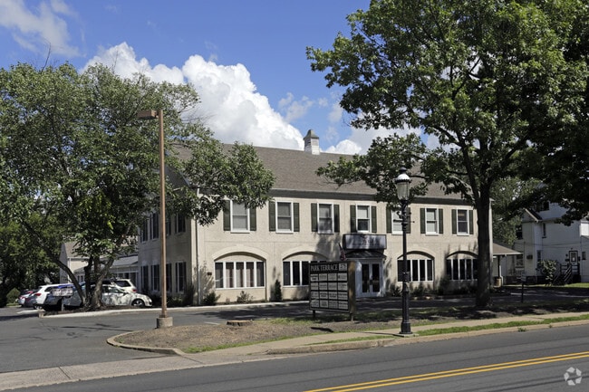
Property Record
275 S Main St, Yardley, PA 19067
Current Lease Availabilities
NEARBY LISTINGS FOR SALE OR LEASE
Property Detail
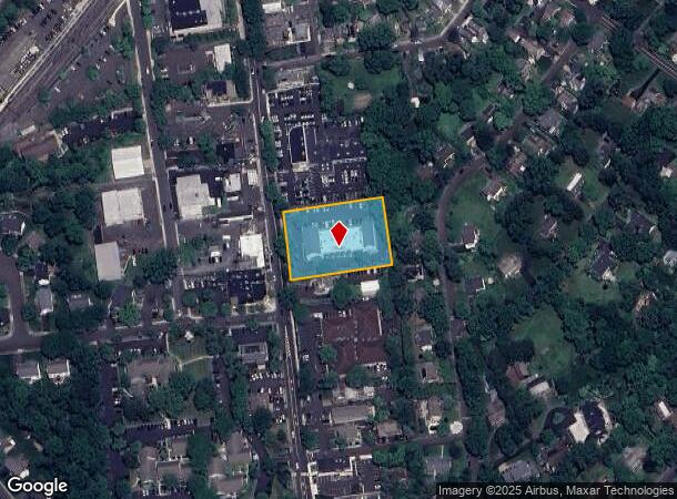
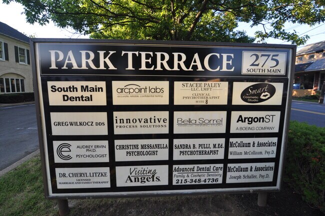
275 S Main St
08-008-468
Herman Silverman
Officebuilding
1.275A ES MAIN ST 368 FT S HILLSIDE AVE
X
Bucks
42017C0292K
Pennsylvania
2024
1.27 AC
2025
Upper Bucks County
105600
Philadelphia
16,962 SF
Philadelphia-Camden-Wilmington, PA-NJ-DE-MD
DEMOGRAPHICS near 275 S Main St
1 mile
3 mile
5 mile
2024 Total Population
7,438
41,298
93,523
2029 Population
7,497
41,353
93,341
Pop Growth 2024-2029
+ 0.79%
+ 0.13%
(0.19%)
Average Age
48
44
43
2024 Total Households
3,396
15,765
33,770
HH Growth 2024-2029
+ 0.88%
+ 0.35%
(0.11%)
Median Household Inc
$114,742
$125,785
$131,339
Avg Household Size
2.10
2.40
2.60
2024 Avg HH Vehicles
2.00
2.00
2.00
Median Home Value
$617,786
$566,695
$521,141
Median Year Built
1961
1979
1986
Nearby Places
Map Layers
Map Styles
 Street
 Aerial
Transit
 Traffic
 Biking
Places
Listings with unknown addresses are not visible on the map
- Restaurants
- Banks
- Shops
- Fitness
- Groceries
PUBLIC TRANSPORTATION
TRANSIT/SUBWAY
Doylestown (R5 - Southeastern Pennsylvania Transportation Authority Regional Rail (SEPTA Regional Rail))
Drive
Walk
Distance
Doylestown (R5 - Southeastern Pennsylvania Transportation Authority Regional Rail (SEPTA Regional Rail))
2 min
5 min
0.3 mi
COMMUTER RAIL
Doylestown (R5 - Southeastern Pennsylvania Transportation Authority Regional Rail (SEPTA Regional Rail))
Drive
Walk
Distance
Doylestown (R5 - Southeastern Pennsylvania Transportation Authority Regional Rail (SEPTA Regional Rail))
2 min
5 min
0.3 mi
Delaware Valley College (R5 - Southeastern Pennsylvania Transportation Authority Regional Rail (SEPTA Regional Rail))
Drive
Walk
Distance
Delaware Valley College (R5 - Southeastern Pennsylvania Transportation Authority Regional Rail (SEPTA Regional Rail))
7 min
2.3 mi
AIRPORT
Trenton Mercer
Drive
Walk
Distance
Trenton Mercer
39 min
23.0 mi
Lehigh Valley International
Drive
Walk
Distance
Lehigh Valley International
62 min
34.1 mi
Philadelphia International
Drive
Walk
Distance
Philadelphia International
69 min
46.0 mi
Freight Ports
Port of Philadelphia
Drive
Walk
Distance
Port of Philadelphia
48 min
25.1 mi
Nearby Properties
Address
Land Use
TOTAL SIZE
Lot Size
Zoning
Address
Land Use
TOTAL SIZE
Lot Size
Zoning
72,937 SF
42.19 AC
CR
Address
Land Use
TOTAL SIZE
Lot Size
Zoning
254,699 SF
22.06 AC
RC
Address
Land Use
TOTAL SIZE
Lot Size
Zoning
192,365 SF
30.81 AC
C2
Address
Land Use
TOTAL SIZE
Lot Size
Zoning
8,120 SF
56.80 AC
C3
Address
Land Use
TOTAL SIZE
Lot Size
Zoning
30,939 SF
28.69 AC
I
Address
Land Use
TOTAL SIZE
Lot Size
Zoning
254,330 SF
25.38 AC
C2
Address
Land Use
TOTAL SIZE
Lot Size
Zoning
344,604 SF
6.95 AC
LI
Address
Land Use
TOTAL SIZE
Lot Size
Zoning
146,924 SF
17.47 AC
C2
Address
Land Use
TOTAL SIZE
Lot Size
Zoning
90,000 SF
7.25 AC
R2
Address
Land Use
TOTAL SIZE
Lot Size
Zoning
77,630 SF
28.53 AC
R2B
Address
Land Use
TOTAL SIZE
Lot Size
Zoning
91,222 SF
13.75 AC
R2
Address
Land Use
TOTAL SIZE
Lot Size
Zoning
109,660 SF
9.81 AC
R3
Address
Land Use
TOTAL SIZE
Lot Size
Zoning
97,496 SF
12.67 AC
R3
Address
Land Use
TOTAL SIZE
Lot Size
Zoning
60,500 SF
5.90 AC
C2
Address
Land Use
TOTAL SIZE
Lot Size
Zoning
230,150 SF
12.10 AC
CR-H
Address
Land Use
TOTAL SIZE
Lot Size
Zoning
77,964 SF
9.79 AC
R3
Address
Land Use
TOTAL SIZE
Lot Size
Zoning
54,090 SF
7.25 AC
R4
Address
Land Use
TOTAL SIZE
Lot Size
Zoning
32,319 SF
7.30 AC
C1
Address
Land Use
TOTAL SIZE
Lot Size
Zoning
114,588 SF
0.82 AC
FC
Address
Land Use
TOTAL SIZE
Lot Size
Zoning
50,049 SF
5.45 AC
PC1
Address
Land Use
TOTAL SIZE
Lot Size
Zoning
16,828 SF
3.28 AC
R2
Address
Land Use
TOTAL SIZE
Lot Size
Zoning
147,540 SF
9.42 AC
C3
Address
Land Use
TOTAL SIZE
Lot Size
Zoning
63,612 SF
0.47 AC
CI
Address
Land Use
TOTAL SIZE
Lot Size
Zoning
38,320 SF
11.91 AC
AG
Address
Land Use
TOTAL SIZE
Lot Size
Zoning
33,658 SF
0.52 AC
Address
Land Use
TOTAL SIZE
Lot Size
Zoning
51,286 SF
12.56 AC
R1
Address
Land Use
TOTAL SIZE
Lot Size
Zoning
63,612 SF
0.50 AC
CI
Address
Land Use
TOTAL SIZE
Lot Size
Zoning
26,134 SF
8.37 AC
C2
Address
Land Use
TOTAL SIZE
Lot Size
Zoning
31,122 SF
9.86 AC
C2
Address
Land Use
TOTAL SIZE
Lot Size
Zoning
42,587 SF
12.09 AC
R1
The World's #1 Commercial Real Estate Marketplace
Connect with us
© 2026 CoStar Group
The information above has been obtained from sources believed reliable. While we do not doubt its accuracy we have not verified it and make no guarantee, warranty or representation about it. It is your responsibility to independently confirm its accuracy and completeness. Any projections, opinions, assumptions, or estimates used are for example only and do not represent the current or future performance of the property. The value of this transaction to you depends on tax and other factors which should be evaluated by your tax, financial, and legal advisors. You and your advisors should conduct a careful, independent investigation of the property to determine to your satisfaction the suitability of the property for your needs.