Property Record
2938 North Ave, Grand Junction, CO 81504

NEARBY LISTINGS FOR SALE OR LEASE
Property Detail
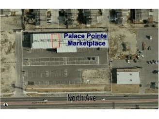
2938 North Ave
Grand Junction, CO
Palace Point Marketplace Condom
2943-083-50-001
UNIT C-1 PALACE POINT MARKETPLACE CONDOMINIUM FIL NO TWO SEC 8 1S 1E AS SHOWN ON CONDO PLAT RECP NO 2299528 AND AS DESC IN DECL B-4086 P-679/703 MESA CO RECDS AND AN UND INT IN GCE
Commercialcondominium
Mesa
X
Colorado
08077C0810G
1
2023
0.04 AC
2024
Colorado Northwest Area
001104
Other Market Areas
1,804 SF
DEMOGRAPHICS near 2938 North Ave
1 mile
3 mile
5 mile
2024 Total Population
10,956
74,727
109,848
2029 Population
11,501
78,358
115,252
Pop Growth 2024-2029
+ 4.97%
+ 4.86%
+ 4.92%
Average Age
39
40
41
2024 Total Households
4,499
30,197
44,765
HH Growth 2024-2029
+ 5.07%
+ 5.00%
+ 5.03%
Median Household Inc
$44,778
$53,755
$58,012
Avg Household Size
2.30
2.30
2.30
2024 Avg HH Vehicles
2.00
2.00
2.00
Median Home Value
$233,386
$262,267
$284,571
Median Year Built
1984
1984
1985
Nearby Places
Map Layers
Map Styles
 Street
 Aerial
Transit
 Traffic
 Biking
Places
Listings with unknown addresses are not visible on the map
- Restaurants
- Banks
- Shops
- Fitness
- Groceries
PUBLIC TRANSPORTATION
COMMUTER RAIL
Drive
Walk
Distance
9 min
4.1 mi
AIRPORT
Grand Junction Regional
Drive
Walk
Distance
Grand Junction Regional
13 min
5.5 mi
SALE & LEASE HISTORY
LISTING DATE
SALE/LEASE

Sep 25, 2016
For Lease
Aug 05, 2017
For Sale
Nearby Properties
Address
Land Use
TOTAL SIZE
Lot Size
Zoning
Address
Land Use
TOTAL SIZE
Lot Size
Zoning
365,495 SF
20.90 AC
CSR
Address
Land Use
TOTAL SIZE
Lot Size
Zoning
482,392 SF
24.70 AC
CSR
Address
Land Use
TOTAL SIZE
Lot Size
Zoning
429,786 SF
16.99 AC
CSR
Address
Land Use
TOTAL SIZE
Lot Size
Zoning
127,583 SF
12.35 AC
C-1
Address
Land Use
TOTAL SIZE
Lot Size
Zoning
181,976 SF
14.80 AC
CSR
Address
Land Use
TOTAL SIZE
Lot Size
Zoning
180,396 SF
17.75 AC
CSR
Address
Land Use
TOTAL SIZE
Lot Size
Zoning
227,855 SF
37.91 AC
Address
Land Use
TOTAL SIZE
Lot Size
Zoning
75,770 SF
82.62 AC
CSR
Address
Land Use
TOTAL SIZE
Lot Size
Zoning
130,260 SF
0.20 AC
C-1
Address
Land Use
TOTAL SIZE
Lot Size
Zoning
113,925 SF
0.16 AC
PD
Address
Land Use
TOTAL SIZE
Lot Size
Zoning
82,986 SF
4.20 AC
PD
Address
Land Use
TOTAL SIZE
Lot Size
Zoning
105,693 SF
18.23 AC
CSR
Address
Land Use
TOTAL SIZE
Lot Size
Zoning
110,905 SF
29.81 AC
RSF-4
Address
Land Use
TOTAL SIZE
Lot Size
Zoning
112,810 SF
6.33 AC
MU
Address
Land Use
TOTAL SIZE
Lot Size
Zoning
69,390 SF
0.14 AC
C-1
Address
Land Use
TOTAL SIZE
Lot Size
Zoning
93,531 SF
5.19 AC
Address
Land Use
TOTAL SIZE
Lot Size
Zoning
94,639 SF
0.16 AC
C-1
Address
Land Use
TOTAL SIZE
Lot Size
Zoning
95,382 SF
16.48 AC
RSF-4
Address
Land Use
TOTAL SIZE
Lot Size
Zoning
66,178 SF
2.02 AC
PD
Address
Land Use
TOTAL SIZE
Lot Size
Zoning
83,518 SF
1.45 AC
CSR
Address
Land Use
TOTAL SIZE
Lot Size
Zoning
70,394 SF
6.19 AC
PD
Address
Land Use
TOTAL SIZE
Lot Size
Zoning
79,905 SF
8.43 AC
PD
Address
Land Use
TOTAL SIZE
Lot Size
Zoning
87,806 SF
0.11 AC
Address
Land Use
TOTAL SIZE
Lot Size
Zoning
222,950 SF
17.36 AC
C-1
Address
Land Use
TOTAL SIZE
Lot Size
Zoning
43,390 SF
3.80 AC
Address
Land Use
TOTAL SIZE
Lot Size
Zoning
60,530 SF
8.42 AC
Address
Land Use
TOTAL SIZE
Lot Size
Zoning
53,104 SF
22.43 AC
AFT
Address
Land Use
TOTAL SIZE
Lot Size
Zoning
45,000 SF
0.20 AC
Address
Land Use
TOTAL SIZE
Lot Size
Zoning
57,297 SF
9.39 AC
RSF-4
The World's #1 Commercial Real Estate Marketplace
Connect with us
© 2026 CoStar Group
The information above has been obtained from sources believed reliable. While we do not doubt its accuracy we have not verified it and make no guarantee, warranty or representation about it. It is your responsibility to independently confirm its accuracy and completeness. Any projections, opinions, assumptions, or estimates used are for example only and do not represent the current or future performance of the property. The value of this transaction to you depends on tax and other factors which should be evaluated by your tax, financial, and legal advisors. You and your advisors should conduct a careful, independent investigation of the property to determine to your satisfaction the suitability of the property for your needs.