Property Record
3301 W Alameda Ave, Denver, CO 80219
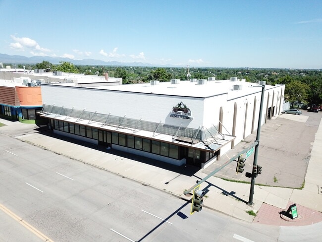
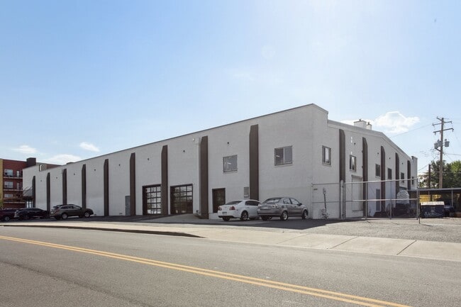
This Property Is For Sale
NEARBY LISTINGS FOR SALE OR LEASE
Property Detail
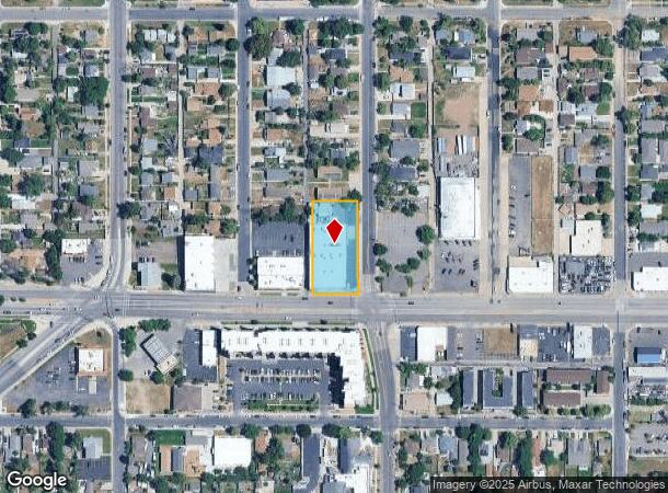
3301 W Alameda Ave
Denver-Aurora-Centennial, CO
Westlawn Gardens
5086-28-020
L 30 TO 39 INC BLK 5 WESTLAWN GARDENS
Storebuilding
Denver
X
Colorado
0800460184J
30-39
2024
0.72 AC
2025
West
000903
Denver
27,055 SF
DEMOGRAPHICS near 3301 W Alameda Ave
1 mile
3 mile
5 mile
2024 Total Population
24,101
192,923
507,619
2029 Population
23,956
194,762
512,218
Pop Growth 2024-2029
(0.60%)
+ 0.95%
+ 0.91%
Average Age
35
37
38
2024 Total Households
7,537
82,634
238,167
HH Growth 2024-2029
(0.76%)
+ 1.20%
+ 1.05%
Median Household Inc
$49,545
$68,905
$80,467
Avg Household Size
3.10
2.20
2.00
2024 Avg HH Vehicles
2.00
2.00
2.00
Median Home Value
$355,142
$456,555
$592,556
Median Year Built
1954
1964
1968
Nearby Places
Map Layers
Map Styles
 Street
 Aerial
Transit
 Traffic
 Biking
Places
Listings with unknown addresses are not visible on the map
- Restaurants
- Banks
- Shops
- Fitness
- Groceries
PUBLIC TRANSPORTATION
COMMUTER RAIL
Union Station: LoDo-Coors Field-16th Street Mall (C Line - Denver Regional Transportation District Light Rail (TheRide), E Line - Denver Regional Transportation District Light Rail (TheRide), W Line - Denver Regional Transportation District Light Rail (TheRide))
Drive
Walk
Distance
Union Station: LoDo-Coors Field-16th Street Mall (C Line - Denver Regional Transportation District Light Rail (TheRide), E Line - Denver Regional Transportation District Light Rail (TheRide), W Line - Denver Regional Transportation District Light Rail (TheRide))
10 min
4.5 mi
Drive
Walk
Distance
10 min
4.5 mi
AIRPORT
Denver International
Drive
Walk
Distance
Denver International
40 min
28.6 mi
Nearby Properties
Address
Land Use
TOTAL SIZE
Lot Size
Zoning
Address
Land Use
TOTAL SIZE
Lot Size
Zoning
1,882,179 SF
21.15 AC
D-TD
Address
Land Use
TOTAL SIZE
Lot Size
Zoning
1,721,086 SF
21.34 AC
C-MU-30
Address
Land Use
TOTAL SIZE
Lot Size
Zoning
598,652 SF
1.38 AC
G-TR
Address
Land Use
TOTAL SIZE
Lot Size
Zoning
729,679 SF
C-MX
Address
Land Use
TOTAL SIZE
Lot Size
Zoning
472,235 SF
1.98 AC
C-RX
Address
Land Use
TOTAL SIZE
Lot Size
Zoning
1,096,923 SF
16.14 AC
CMP-H
Address
Land Use
TOTAL SIZE
Lot Size
Zoning
411,402 SF
6.34 AC
C-RX
Address
Land Use
TOTAL SIZE
Lot Size
Zoning
297,776 SF
2.88 AC
C-MX
Address
Land Use
TOTAL SIZE
Lot Size
Zoning
296,778 SF
2.28 AC
U-MS
Address
Land Use
TOTAL SIZE
Lot Size
Zoning
341,972 SF
1.21 AC
G-TR
Address
Land Use
TOTAL SIZE
Lot Size
Zoning
1,048,471 SF
2.44 AC
PUD
Address
Land Use
TOTAL SIZE
Lot Size
Zoning
614,750 SF
0.23 AC
D-C
Address
Land Use
TOTAL SIZE
Lot Size
Zoning
254,661 SF
1.12 AC
G-TR
Address
Land Use
TOTAL SIZE
Lot Size
Zoning
656,257 SF
3.05 AC
D-CV
Address
Land Use
TOTAL SIZE
Lot Size
Zoning
245,760 SF
1.48 AC
C-MS
Address
Land Use
TOTAL SIZE
Lot Size
Zoning
200,014 SF
5.14 AC
I-MX-3
Address
Land Use
TOTAL SIZE
Lot Size
Zoning
206,526 SF
0.43 AC
G-TR
Address
Land Use
TOTAL SIZE
Lot Size
Zoning
310,408 SF
0.79 AC
C-MX
Address
Land Use
TOTAL SIZE
Lot Size
Zoning
252,092 SF
4.75 AC
C-RX
Address
Land Use
TOTAL SIZE
Lot Size
Zoning
337,495 SF
0.57 AC
D-C
Address
Land Use
TOTAL SIZE
Lot Size
Zoning
677,832 SF
2.42 AC
D-C
Address
Land Use
TOTAL SIZE
Lot Size
Zoning
311,978 SF
0.65 AC
CBD
Address
Land Use
TOTAL SIZE
Lot Size
Zoning
1,078,109 SF
36.79 AC
CMP-EI
Address
Land Use
TOTAL SIZE
Lot Size
Zoning
150,106 SF
2.40 AC
C-RX
Address
Land Use
TOTAL SIZE
Lot Size
Zoning
345,616 SF
3.45 AC
PUD
Address
Land Use
TOTAL SIZE
Lot Size
Zoning
497,777 SF
3.70 AC
D-CV
Address
Land Use
TOTAL SIZE
Lot Size
Zoning
168,523 SF
44.89 AC
CPV-R
Address
Land Use
TOTAL SIZE
Lot Size
Zoning
343,483 SF
5.62 AC
D-TD
Address
Land Use
TOTAL SIZE
Lot Size
Zoning
101,906 SF
2.30 AC
C-RX
Address
Land Use
TOTAL SIZE
Lot Size
Zoning
44.93 AC
CPV-C
The World's #1 Commercial Real Estate Marketplace
Connect with us
© 2026 CoStar Group
The information above has been obtained from sources believed reliable. While we do not doubt its accuracy we have not verified it and make no guarantee, warranty or representation about it. It is your responsibility to independently confirm its accuracy and completeness. Any projections, opinions, assumptions, or estimates used are for example only and do not represent the current or future performance of the property. The value of this transaction to you depends on tax and other factors which should be evaluated by your tax, financial, and legal advisors. You and your advisors should conduct a careful, independent investigation of the property to determine to your satisfaction the suitability of the property for your needs.