Property Record
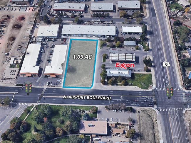
569 Airport Blvd, Aurora, CO 80011

NEARBY LISTINGS FOR SALE OR LEASE
Property Detail
569 Airport Blvd
Denver-Aurora-Lakewood, CO
Airport 66 Sub 1St Flg
1975-08-1-23-002
SUBDIVISIONCD 000670 SUBDIVISIONNAME AIRPORT 66 SUB 1ST FLG BLOCK 001 LOT 002 LOT 2 BLK 1 AIRPORT 66 SUB 1ST FLG
Commercialacreage
Arapahoe
X
Colorado
08005C0181L
002,2
2023
1.09 AC
2024
Aurora
007108
Denver
DEMOGRAPHICS near 569 Airport Blvd
1 Mile
3 Mile
5 Mile
2024 Total Population
8,011
103,703
332,582
2029 Population
7,987
104,761
336,001
Pop Growth 2024-2029
(0.30%)
+ 1.02%
+ 1.03%
Average Age
33
36
37
2024 Total Households
2,621
36,969
119,334
HH Growth 2024-2029
(0.15%)
+ 1.11%
+ 1.05%
Median Household Inc
$62,534
$60,996
$66,082
Avg Household Size
2.80
2.70
2.70
2024 Avg HH Vehicles
2.00
2.00
2.00
Median Home Value
$338,777
$337,352
$369,510
Median Year Built
1988
1982
1983
Nearby Places
Map Layers
Map Styles
 Street
 Aerial
- Restaurants
- Banks
- Shops
- Fitness
- Groceries
PUBLIC TRANSPORTATION
COMMUTER RAIL
40Th Ave & Airport Blvd - Gateway Park Station Track 2 (Union Station to Denver Airport Station - Regional Transportation District)
DRIVE
WALK
Distance
40Th Ave & Airport Blvd - Gateway Park Station Track 2 (Union Station to Denver Airport Station - Regional Transportation District)
9 min
4.2 mi
Peoria Station Track 1 (Union Station to Denver Airport Station - Regional Transportation District)
DRIVE
WALK
Distance
Peoria Station Track 1 (Union Station to Denver Airport Station - Regional Transportation District)
11 min
6.7 mi
AIRPORT
Denver International
DRIVE
WALK
Distance
Denver International
20 min
14.7 mi
Freight Ports
Tulsa Port Of Catoosa
DRIVE
WALK
Distance
Tulsa Port Of Catoosa
715 min
697.7 mi
Nearby Properties
Address
Land Use
TOTAL SIZE
Lot Size
Zoning
Address
Land Use
TOTAL SIZE
Lot Size
Zoning
368,450 SF
48.59 AC
Address
Land Use
TOTAL SIZE
Lot Size
Zoning
353,829 SF
4.51 AC
Address
Land Use
TOTAL SIZE
Lot Size
Zoning
876,549 SF
46.65 AC
Address
Land Use
TOTAL SIZE
Lot Size
Zoning
868,780 SF
105.02 AC
Address
Land Use
TOTAL SIZE
Lot Size
Zoning
704,978 SF
36.17 AC
Address
Land Use
TOTAL SIZE
Lot Size
Zoning
691,200 SF
38.09 AC
Address
Land Use
TOTAL SIZE
Lot Size
Zoning
273,184 SF
1.89 AC
Address
Land Use
TOTAL SIZE
Lot Size
Zoning
512,720 SF
42.32 AC
Address
Land Use
TOTAL SIZE
Lot Size
Zoning
140.42 AC
Address
Land Use
TOTAL SIZE
Lot Size
Zoning
548,510 SF
27.26 AC
Address
Land Use
TOTAL SIZE
Lot Size
Zoning
315,058 SF
36.85 AC
RPCZD
Address
Land Use
TOTAL SIZE
Lot Size
Zoning
433,280 SF
23.46 AC
Address
Land Use
TOTAL SIZE
Lot Size
Zoning
593,928 SF
32.25 AC
Address
Land Use
TOTAL SIZE
Lot Size
Zoning
432,600 SF
30.98 AC
Address
Land Use
TOTAL SIZE
Lot Size
Zoning
672,521 SF
0.61 AC
RB3
Address
Land Use
TOTAL SIZE
Lot Size
Zoning
277,985 SF
19.07 AC
Address
Land Use
TOTAL SIZE
Lot Size
Zoning
385,187 SF
26.62 AC
Address
Land Use
TOTAL SIZE
Lot Size
Zoning
178,235 SF
1.38 AC
RFBAD
Address
Land Use
TOTAL SIZE
Lot Size
Zoning
201,600 SF
44.67 AC
R1
Address
Land Use
TOTAL SIZE
Lot Size
Zoning
355,740 SF
18.20 AC
Address
Land Use
TOTAL SIZE
Lot Size
Zoning
331,923 SF
16.83 AC
Address
Land Use
TOTAL SIZE
Lot Size
Zoning
111,358 SF
1.21 AC
Address
Land Use
TOTAL SIZE
Lot Size
Zoning
326,900 SF
16.21 AC
Address
Land Use
TOTAL SIZE
Lot Size
Zoning
300,759 SF
54.34 AC
Address
Land Use
TOTAL SIZE
Lot Size
Zoning
364,024 SF
23.23 AC
PUD
Address
Land Use
TOTAL SIZE
Lot Size
Zoning
255,045 SF
16.59 AC
Address
Land Use
TOTAL SIZE
Lot Size
Zoning
220,395 SF
7.93 AC
Address
Land Use
TOTAL SIZE
Lot Size
Zoning
386,285 SF
2.72 AC
Address
Land Use
TOTAL SIZE
Lot Size
Zoning
366,800 SF
20.21 AC
Address
Land Use
TOTAL SIZE
Lot Size
Zoning
186,088 SF
10.15 AC
RZIND
The World's #1 Commercial Real Estate Marketplace
Connect with us
© 2025 CoStar Group
The information above has been obtained from sources believed reliable. While we do not doubt its accuracy we have not verified it and make no guarantee, warranty or representation about it. It is your responsibility to independently confirm its accuracy and completeness. Any projections, opinions, assumptions, or estimates used are for example only and do not represent the current or future performance of the property. The value of this transaction to you depends on tax and other factors which should be evaluated by your tax, financial, and legal advisors. You and your advisors should conduct a careful, independent investigation of the property to determine to your satisfaction the suitability of the property for your needs.