Property Record
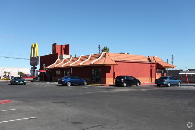
5947 Spring Mountain Rd, Las Vegas, NV 89146


Property Detail
5947 Spring Mountain Rd
163-13-202-001
PARCEL MAP FILE 44 PAGE 82 LOT 1
Restaurantbuilding
Clark
C1
Nevada
B and X Area of moderate flood hazard, usually the area between the limits of the 100-year and 500-year floods.
1
2026
1.04 AC
2026
Central West Las Vegas
002935
Las Vegas
4,989 SF
Las Vegas-Henderson-North Las Vegas, NV
NEARBY LISTINGS FOR SALE OR LEASE
DEMOGRAPHICS near 5947 Spring Mountain Rd
1 mile
3 mile
5 mile
2025 Total Population
19,019
185,147
450,110
2030 Population
19,919
196,040
474,944
Pop Growth 2025-2030
+ 4.73%
+ 5.88%
+ 5.52%
Average Age
42
41
40
2025 Total Households
7,664
75,195
184,010
HH Growth 2025-2030
+ 4.76%
+ 6.11%
+ 5.60%
Median Household Inc
$61,100
$61,213
$62,831
Avg Household Size
2.40
2.40
2.40
2025 Avg HH Vehicles
2.00
2.00
2.00
Median Home Value
$394,017
$389,052
$407,750
Median Year Built
1982
1987
1989
Nearby Places
Map Layers
Map Styles
 Street
 Aerial
Layers
 Traffic
 Biking
Places
Listings with unknown addresses are not visible on the map
- Restaurants
- Banks
- Shops
- Fitness
- Groceries
PUBLIC TRANSPORTATION
AIRPORT
Harry Reid International
Drive
Walk
Distance
Harry Reid International
13 min
6.7 mi
Boulder City Municipal
Drive
Walk
Distance
Boulder City Municipal
41 min
27.7 mi
Freight Ports
Port of Long Beach
Drive
Walk
Distance
Port of Long Beach
315 min
282.2 mi
Nearby Properties
Address
Land Use
TOTAL SIZE
Lot Size
Zoning
Address
Land Use
TOTAL SIZE
Lot Size
Zoning
1,546,466 SF
61.43 AC
H1
Address
Land Use
TOTAL SIZE
Lot Size
Zoning
2,207,746 SF
74.17 AC
Address
Land Use
TOTAL SIZE
Lot Size
Zoning
820,224 SF
59.80 AC
H1
Address
Land Use
TOTAL SIZE
Lot Size
Zoning
1,447,338 SF
65.25 AC
H1
Address
Land Use
TOTAL SIZE
Lot Size
Zoning
2,414,853 SF
16.59 AC
H1
Address
Land Use
TOTAL SIZE
Lot Size
Zoning
112,160 SF
20.60 AC
Address
Land Use
TOTAL SIZE
Lot Size
Zoning
248,689 SF
19.45 AC
H1
Address
Land Use
TOTAL SIZE
Lot Size
Zoning
318,755 SF
29.92 AC
Address
Land Use
TOTAL SIZE
Lot Size
Zoning
1,911,901 SF
1.24 AC
Address
Land Use
TOTAL SIZE
Lot Size
Zoning
299,144 SF
19.37 AC
Address
Land Use
TOTAL SIZE
Lot Size
Zoning
777,838 SF
36.14 AC
H1
Address
Land Use
TOTAL SIZE
Lot Size
Zoning
3,200 SF
16.74 AC
Address
Land Use
TOTAL SIZE
Lot Size
Zoning
1,744,547 SF
8.25 AC
Address
Land Use
TOTAL SIZE
Lot Size
Zoning
659,669 SF
24.79 AC
H1
Address
Land Use
TOTAL SIZE
Lot Size
Zoning
1,069,498 SF
28.36 AC
H1
Address
Land Use
TOTAL SIZE
Lot Size
Zoning
987,719 SF
12.98 AC
H1
Address
Land Use
TOTAL SIZE
Lot Size
Zoning
945,212 SF
0.60 AC
Address
Land Use
TOTAL SIZE
Lot Size
Zoning
115,059 SF
30.12 AC
Address
Land Use
TOTAL SIZE
Lot Size
Zoning
611,977 SF
6.82 AC
Address
Land Use
TOTAL SIZE
Lot Size
Zoning
740,584 SF
0.98 AC
Address
Land Use
TOTAL SIZE
Lot Size
Zoning
611,832 SF
10 AC
Address
Land Use
TOTAL SIZE
Lot Size
Zoning
32,655 SF
2.40 AC
Address
Land Use
TOTAL SIZE
Lot Size
Zoning
962,611 SF
28.43 AC
Address
Land Use
TOTAL SIZE
Lot Size
Zoning
412,086 SF
33.58 AC
CP
Address
Land Use
TOTAL SIZE
Lot Size
Zoning
109,306 SF
25.79 AC
H1
Address
Land Use
TOTAL SIZE
Lot Size
Zoning
153,122 SF
4.25 AC
Address
Land Use
TOTAL SIZE
Lot Size
Zoning
40 AC
PF
Address
Land Use
TOTAL SIZE
Lot Size
Zoning
Address
Land Use
TOTAL SIZE
Lot Size
Zoning
53,114 SF
2.16 AC
The World's #1 Commercial Real Estate Marketplace
Connect with us
© 2026 CoStar Group
The information above has been obtained from sources believed reliable. While we do not doubt its accuracy we have not verified it and make no guarantee, warranty or representation about it. It is your responsibility to independently confirm its accuracy and completeness. Any projections, opinions, assumptions, or estimates used are for example only and do not represent the current or future performance of the property. The value of this transaction to you depends on tax and other factors which should be evaluated by your tax, financial, and legal advisors. You and your advisors should conduct a careful, independent investigation of the property to determine to your satisfaction the suitability of the property for your needs.