Property Record
5991 W Colfax Ave, Lakewood, CO 80214
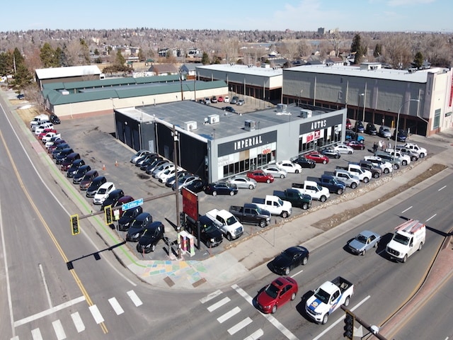


Property Detail
5991 W Colfax Ave
Denver-Aurora-Centennial, CO
SECTION 36 TOWNSHIP 03 RANGE 69 SUBDIVISIONCD 1000424 SUBDIVISIONNAME STATE SUB EDGEWATER LL ADJ NO 3 LOT 0022 SIZE: 68048 VALUE: 1.562
39-364-09-023
JEFFERSON
Commercialnec
Colorado
B and X Area of moderate flood hazard, usually the area between the limits of the 100-year and 500-year floods.
22
2025
1.56 AC
2025
West
011401
Denver
6,298 SF
NEARBY LISTINGS FOR SALE OR LEASE
DEMOGRAPHICS near 5991 W Colfax Ave
1 mile
3 mile
5 mile
2025 Total Population
20,692
162,973
468,786
2030 Population
21,102
165,406
476,933
Pop Growth 2025-2030
+ 1.98%
+ 1.49%
+ 1.74%
Average Age
38
39
39
2025 Total Households
9,474
71,294
217,119
HH Growth 2025-2030
+ 1.82%
+ 1.66%
+ 1.99%
Median Household Inc
$75,253
$85,554
$90,611
Avg Household Size
2.10
2.20
2.10
2025 Avg HH Vehicles
2.00
2.00
2.00
Median Home Value
$612,981
$672,674
$646,554
Median Year Built
1969
1965
1971
Nearby Places
Map Layers
Map Styles
 Street
 Aerial
Layers
 Traffic
 Biking
Places
Listings with unknown addresses are not visible on the map
- Restaurants
- Banks
- Shops
- Fitness
- Groceries
PUBLIC TRANSPORTATION
TRANSIT/SUBWAY
Lamar (W Line - Denver Regional Transportation District Light Rail (TheRide))
Drive
Walk
Distance
Lamar (W Line - Denver Regional Transportation District Light Rail (TheRide))
2 min
10 min
0.5 mi
Sheridan (W Line - Denver Regional Transportation District Light Rail (TheRide))
Drive
Walk
Distance
Sheridan (W Line - Denver Regional Transportation District Light Rail (TheRide))
3 min
16 min
0.8 mi
COMMUTER RAIL
Union Station: LoDo-Coors Field-16th Street Mall (C Line - Denver Regional Transportation District Light Rail (TheRide), E Line - Denver Regional Transportation District Light Rail (TheRide), W Line - Denver Regional Transportation District Light Rail (TheRide))
Drive
Walk
Distance
Union Station: LoDo-Coors Field-16th Street Mall (C Line - Denver Regional Transportation District Light Rail (TheRide), E Line - Denver Regional Transportation District Light Rail (TheRide), W Line - Denver Regional Transportation District Light Rail (TheRide))
11 min
4.3 mi
Drive
Walk
Distance
11 min
4.3 mi
AIRPORT
Denver International
Drive
Walk
Distance
Denver International
41 min
29.2 mi
SALE & LEASE HISTORY
LISTING DATE
SALE/LEASE

Mar 09, 2021
For Sale
Nearby Properties
Address
Land Use
TOTAL SIZE
Lot Size
Zoning
Address
Land Use
TOTAL SIZE
Lot Size
Zoning
1,721,086 SF
21.34 AC
C-MU-30
Address
Land Use
TOTAL SIZE
Lot Size
Zoning
565,418 SF
4.07 AC
C-RX
Address
Land Use
TOTAL SIZE
Lot Size
Zoning
729,679 SF
C-MX
Address
Land Use
TOTAL SIZE
Lot Size
Zoning
411,402 SF
6.34 AC
C-RX
Address
Land Use
TOTAL SIZE
Lot Size
Zoning
310,267 SF
1.69 AC
C-MX
Address
Land Use
TOTAL SIZE
Lot Size
Zoning
245,760 SF
1.48 AC
C-MS
Address
Land Use
TOTAL SIZE
Lot Size
Zoning
252,092 SF
4.75 AC
C-RX
Address
Land Use
TOTAL SIZE
Lot Size
Zoning
162,639 SF
1.44 AC
C-MX
Address
Land Use
TOTAL SIZE
Lot Size
Zoning
185,265 SF
4.37 AC
G-MU
Address
Land Use
TOTAL SIZE
Lot Size
Zoning
168,523 SF
44.89 AC
CPV-R
Address
Land Use
TOTAL SIZE
Lot Size
Zoning
424,862 SF
32.28 AC
G-MU-3
Address
Land Use
TOTAL SIZE
Lot Size
Zoning
133,938 SF
1.72 AC
Address
Land Use
TOTAL SIZE
Lot Size
Zoning
101,906 SF
2.30 AC
C-RX
Address
Land Use
TOTAL SIZE
Lot Size
Zoning
92,072 SF
2.98 AC
Address
Land Use
TOTAL SIZE
Lot Size
Zoning
44.93 AC
CPV-C
Address
Land Use
TOTAL SIZE
Lot Size
Zoning
76,877 SF
1.45 AC
C-RX
Address
Land Use
TOTAL SIZE
Lot Size
Zoning
104,837 SF
0.72 AC
U-MS
Address
Land Use
TOTAL SIZE
Lot Size
Zoning
61,026 SF
2.81 AC
Address
Land Use
TOTAL SIZE
Lot Size
Zoning
128,779 SF
3.80 AC
Address
Land Use
TOTAL SIZE
Lot Size
Zoning
33.40 AC
C-MU-30
Address
Land Use
TOTAL SIZE
Lot Size
Zoning
112,266 SF
2.41 AC
Address
Land Use
TOTAL SIZE
Lot Size
Zoning
88,507 SF
5.53 AC
Address
Land Use
TOTAL SIZE
Lot Size
Zoning
111,544 SF
2.90 AC
Address
Land Use
TOTAL SIZE
Lot Size
Zoning
323,426 SF
29.84 AC
I-B
Address
Land Use
TOTAL SIZE
Lot Size
Zoning
80,030 SF
2.25 AC
Address
Land Use
TOTAL SIZE
Lot Size
Zoning
113,566 SF
4.94 AC
Address
Land Use
TOTAL SIZE
Lot Size
Zoning
30,316 SF
0.85 AC
U-MS
Address
Land Use
TOTAL SIZE
Lot Size
Zoning
333,925 SF
3.34 AC
C-MX-5
Address
Land Use
TOTAL SIZE
Lot Size
Zoning
71,706 SF
1.81 AC
Address
Land Use
TOTAL SIZE
Lot Size
Zoning
103,594 SF
1 AC
The World's #1 Commercial Real Estate Marketplace
Connect with us
© 2026 CoStar Group
The information above has been obtained from sources believed reliable. While we do not doubt its accuracy we have not verified it and make no guarantee, warranty or representation about it. It is your responsibility to independently confirm its accuracy and completeness. Any projections, opinions, assumptions, or estimates used are for example only and do not represent the current or future performance of the property. The value of this transaction to you depends on tax and other factors which should be evaluated by your tax, financial, and legal advisors. You and your advisors should conduct a careful, independent investigation of the property to determine to your satisfaction the suitability of the property for your needs.