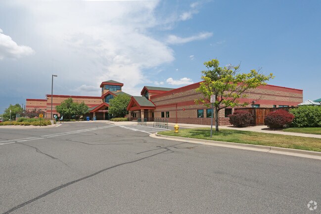
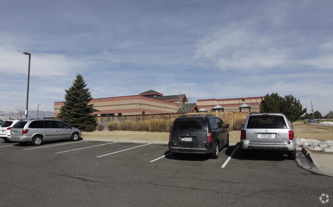
Property Record
6350 Eldridge St, Arvada, CO 80004

Save to a Folder
{{folder.Name}}
{{folder.ListingIds.length}} Properties
{{folder.ListingIds.length}} Property
Create a New Folder
Property Detail
6350 Eldridge St
Denver-Aurora-Centennial, CO
SECTION 07 TOWNSHIP 03 RANGE 69 QTR NE SUBDIVISIONCD 858360 SUBDIVISIONNAME WYNDHAM PARK FLG 5 BLOCK 001 LOT 0001 SIZE: 432827 TRACT VALUE: 9.936
39-071-07-126
JEFFERSON
Commercialnec
Colorado
B and X Area of moderate flood hazard, usually the area between the limits of the 100-year and 500-year floods.
1
0
9.94 AC
2025
Northwest
009851
Denver
58,027 SF
NEARBY LISTINGS FOR SALE OR LEASE
DEMOGRAPHICS near 6350 Eldridge St
1 mile
3 mile
5 mile
2025 Total Population
10,027
68,510
168,716
2030 Population
9,921
68,250
167,914
Pop Growth 2025-2030
(1.06%)
(0.38%)
(0.48%)
Average Age
44
43
42
2025 Total Households
3,957
26,862
68,504
HH Growth 2025-2030
(1.24%)
(0.41%)
(0.53%)
Median Household Inc
$124,488
$126,006
$112,151
Avg Household Size
2.50
2.50
2.40
2025 Avg HH Vehicles
2.00
2.00
2.00
Median Home Value
$719,264
$748,795
$718,359
Median Year Built
1988
1985
1977
Nearby Places
Map Layers
Map Styles
 Street
 Aerial
Layers
 Traffic
 Biking
Places
Listings with unknown addresses are not visible on the map
- Restaurants
- Banks
- Shops
- Fitness
- Groceries
PUBLIC TRANSPORTATION
COMMUTER RAIL
Drive
Walk
Distance
7 min
3.1 mi
Drive
Walk
Distance
7 min
3.9 mi
AIRPORT
Denver International
Drive
Walk
Distance
Denver International
45 min
33.3 mi
Nearby Properties
Address
Land Use
TOTAL SIZE
Lot Size
Zoning
Address
Land Use
TOTAL SIZE
Lot Size
Zoning
830,160 SF
26.93 AC
Address
Land Use
TOTAL SIZE
Lot Size
Zoning
97,944 SF
6.34 AC
Address
Land Use
TOTAL SIZE
Lot Size
Zoning
49,337 SF
4.02 AC
Address
Land Use
TOTAL SIZE
Lot Size
Zoning
72,630 SF
5.08 AC
Address
Land Use
TOTAL SIZE
Lot Size
Zoning
59,824 SF
0.96 AC
Address
Land Use
TOTAL SIZE
Lot Size
Zoning
269,013 SF
31.89 AC
Address
Land Use
TOTAL SIZE
Lot Size
Zoning
253,643 SF
50.87 AC
A2
Address
Land Use
TOTAL SIZE
Lot Size
Zoning
353,286 SF
14.49 AC
Address
Land Use
TOTAL SIZE
Lot Size
Zoning
40,163 SF
5.46 AC
Address
Land Use
TOTAL SIZE
Lot Size
Zoning
48,225 SF
1.81 AC
Address
Land Use
TOTAL SIZE
Lot Size
Zoning
227,132 SF
11.95 AC
Address
Land Use
TOTAL SIZE
Lot Size
Zoning
363,989 SF
30.10 AC
Address
Land Use
TOTAL SIZE
Lot Size
Zoning
520,896 SF
24.42 AC
I1
Address
Land Use
TOTAL SIZE
Lot Size
Zoning
192,500 SF
10.97 AC
Address
Land Use
TOTAL SIZE
Lot Size
Zoning
260,325 SF
13.70 AC
Address
Land Use
TOTAL SIZE
Lot Size
Zoning
365,230 SF
12.51 AC
Address
Land Use
TOTAL SIZE
Lot Size
Zoning
389,561 SF
10.73 AC
Address
Land Use
TOTAL SIZE
Lot Size
Zoning
16,189 SF
1.44 AC
Address
Land Use
TOTAL SIZE
Lot Size
Zoning
57,453 SF
2.83 AC
Address
Land Use
TOTAL SIZE
Lot Size
Zoning
345,445 SF
8.41 AC
Address
Land Use
TOTAL SIZE
Lot Size
Zoning
262,699 SF
13.10 AC
A2
Address
Land Use
TOTAL SIZE
Lot Size
Zoning
215,878 SF
11.82 AC
A2
Address
Land Use
TOTAL SIZE
Lot Size
Zoning
425,828 SF
27.42 AC
Address
Land Use
TOTAL SIZE
Lot Size
Zoning
279,715 SF
12.20 AC
Address
Land Use
TOTAL SIZE
Lot Size
Zoning
101,761 SF
4.34 AC
Address
Land Use
TOTAL SIZE
Lot Size
Zoning
142,200 SF
9.82 AC
Address
Land Use
TOTAL SIZE
Lot Size
Zoning
149,760 SF
8.64 AC
Address
Land Use
TOTAL SIZE
Lot Size
Zoning
223,158 SF
9.42 AC
I1
Address
Land Use
TOTAL SIZE
Lot Size
Zoning
130,662 SF
9.67 AC
Address
Land Use
TOTAL SIZE
Lot Size
Zoning
67,520 SF
6.46 AC
The World's #1 Commercial Real Estate Marketplace
Connect with us
© 2026 CoStar Group
The information above has been obtained from sources believed reliable. While we do not doubt its accuracy we have not verified it and make no guarantee, warranty or representation about it. It is your responsibility to independently confirm its accuracy and completeness. Any projections, opinions, assumptions, or estimates used are for example only and do not represent the current or future performance of the property. The value of this transaction to you depends on tax and other factors which should be evaluated by your tax, financial, and legal advisors. You and your advisors should conduct a careful, independent investigation of the property to determine to your satisfaction the suitability of the property for your needs.