Property Record
7833 W Colfax Ave, Denver, CO 80214
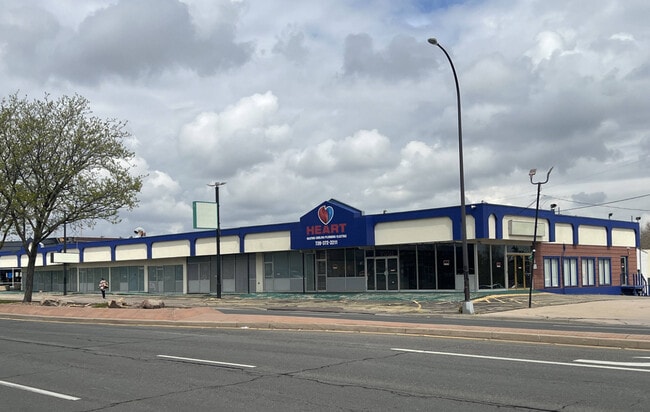

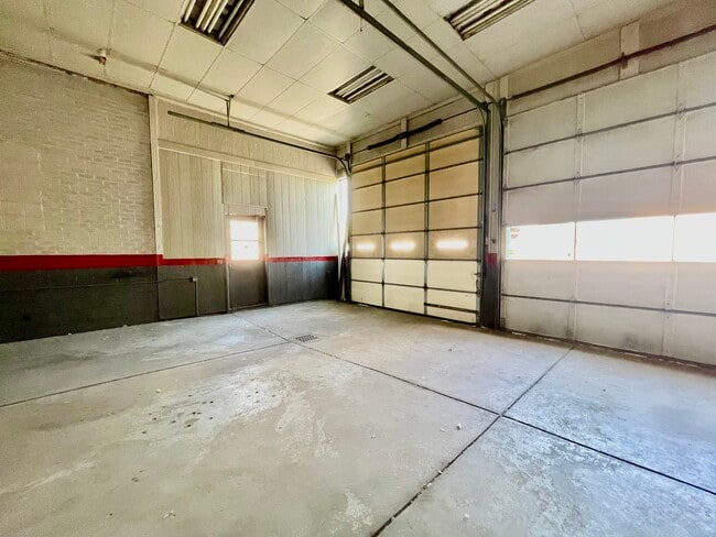
This Property Is For Sale
Current Lease Availabilities
Property Detail
7833 W Colfax Ave
Denver-Aurora-Centennial, CO
SECTION 35 TOWNSHIP 03 RANGE 69 SUBDIVISIONCD 560800 SUBDIVISIONNAME NORWOOD BLOCK 003 LOT 0003 SIZE: 84000 TRACT 00D VALUE: 1.928
39-353-17-002
JEFFERSON
Commercialnec
Colorado
AE The base floodplain where base flood elevations are provided. AE Zones are now used on new format FIRMs instead of A1-A30 Zones.
3
2025
1.93 AC
2025
West
011402
Denver
30,948 SF
NEARBY LISTINGS FOR SALE OR LEASE
DEMOGRAPHICS near 7833 W Colfax Ave
1 mile
3 mile
5 mile
2025 Total Population
15,675
140,002
388,800
2030 Population
15,683
141,486
393,194
Pop Growth 2025-2030
+ 0.05%
+ 1.06%
+ 1.13%
Average Age
41
40
39
2025 Total Households
7,127
61,225
169,751
HH Growth 2025-2030
(0.07%)
+ 1.15%
+ 1.30%
Median Household Inc
$67,488
$83,081
$91,910
Avg Household Size
2.10
2.20
2.20
2025 Avg HH Vehicles
2.00
2.00
2.00
Median Home Value
$569,486
$667,481
$658,826
Median Year Built
1970
1966
1971
Nearby Places
Map Layers
Map Styles
 Street
 Aerial
Layers
 Traffic
 Biking
Places
Listings with unknown addresses are not visible on the map
- Restaurants
- Banks
- Shops
- Fitness
- Groceries
PUBLIC TRANSPORTATION
TRANSIT/SUBWAY
Lakewood/Wadsworth (W Line - Denver Regional Transportation District Light Rail (TheRide))
Drive
Walk
Distance
Lakewood/Wadsworth (W Line - Denver Regional Transportation District Light Rail (TheRide))
2 min
10 min
0.6 mi
COMMUTER RAIL
Arvada Ridge Station Track 1 (Union Station to Wheat Ridge Ward Station - Regional Transportation District)
Drive
Walk
Distance
Arvada Ridge Station Track 1 (Union Station to Wheat Ridge Ward Station - Regional Transportation District)
11 min
5.9 mi
Arvada Ridge Station Track 2 (Union Station to Wheat Ridge Ward Station - Regional Transportation District)
Drive
Walk
Distance
Arvada Ridge Station Track 2 (Union Station to Wheat Ridge Ward Station - Regional Transportation District)
11 min
5.9 mi
AIRPORT
Denver International
Drive
Walk
Distance
Denver International
40 min
30.5 mi
Freight Ports
Tulsa Port Of Catoosa
Drive
Walk
Distance
Tulsa Port Of Catoosa
738 min
716.0 mi
Nearby Properties
Address
Land Use
TOTAL SIZE
Lot Size
Zoning
Address
Land Use
TOTAL SIZE
Lot Size
Zoning
943,179 SF
23.96 AC
Address
Land Use
TOTAL SIZE
Lot Size
Zoning
245,760 SF
1.48 AC
C-MS
Address
Land Use
TOTAL SIZE
Lot Size
Zoning
82,133 SF
6.07 AC
Address
Land Use
TOTAL SIZE
Lot Size
Zoning
3,195,026 SF
562.97 AC
Address
Land Use
TOTAL SIZE
Lot Size
Zoning
133,938 SF
1.72 AC
Address
Land Use
TOTAL SIZE
Lot Size
Zoning
92,072 SF
2.98 AC
Address
Land Use
TOTAL SIZE
Lot Size
Zoning
94,560 SF
6.03 AC
Address
Land Use
TOTAL SIZE
Lot Size
Zoning
61,026 SF
2.81 AC
Address
Land Use
TOTAL SIZE
Lot Size
Zoning
128,779 SF
3.80 AC
Address
Land Use
TOTAL SIZE
Lot Size
Zoning
112,266 SF
2.41 AC
Address
Land Use
TOTAL SIZE
Lot Size
Zoning
88,507 SF
5.53 AC
Address
Land Use
TOTAL SIZE
Lot Size
Zoning
111,544 SF
2.90 AC
Address
Land Use
TOTAL SIZE
Lot Size
Zoning
80,030 SF
2.25 AC
Address
Land Use
TOTAL SIZE
Lot Size
Zoning
113,566 SF
4.94 AC
Address
Land Use
TOTAL SIZE
Lot Size
Zoning
71,706 SF
1.81 AC
Address
Land Use
TOTAL SIZE
Lot Size
Zoning
103,594 SF
1 AC
Address
Land Use
TOTAL SIZE
Lot Size
Zoning
76,685 SF
2.24 AC
Address
Land Use
TOTAL SIZE
Lot Size
Zoning
56,930 SF
7.59 AC
Address
Land Use
TOTAL SIZE
Lot Size
Zoning
53,912 SF
0.90 AC
Address
Land Use
TOTAL SIZE
Lot Size
Zoning
68,269 SF
0.95 AC
Address
Land Use
TOTAL SIZE
Lot Size
Zoning
90,776 SF
5 AC
Address
Land Use
TOTAL SIZE
Lot Size
Zoning
115,307 SF
2.40 AC
Address
Land Use
TOTAL SIZE
Lot Size
Zoning
102,182 SF
3.70 AC
CMP
Address
Land Use
TOTAL SIZE
Lot Size
Zoning
68,791 SF
1.37 AC
Address
Land Use
TOTAL SIZE
Lot Size
Zoning
53,503 SF
2.35 AC
Address
Land Use
TOTAL SIZE
Lot Size
Zoning
34,642 SF
C-MX-8
Address
Land Use
TOTAL SIZE
Lot Size
Zoning
60,906 SF
2.87 AC
Address
Land Use
TOTAL SIZE
Lot Size
Zoning
233,688 SF
22.37 AC
Address
Land Use
TOTAL SIZE
Lot Size
Zoning
45,703 SF
1.10 AC
Address
Land Use
TOTAL SIZE
Lot Size
Zoning
198,081 SF
The World's #1 Commercial Real Estate Marketplace
Connect with us
© 2026 CoStar Group
The information above has been obtained from sources believed reliable. While we do not doubt its accuracy we have not verified it and make no guarantee, warranty or representation about it. It is your responsibility to independently confirm its accuracy and completeness. Any projections, opinions, assumptions, or estimates used are for example only and do not represent the current or future performance of the property. The value of this transaction to you depends on tax and other factors which should be evaluated by your tax, financial, and legal advisors. You and your advisors should conduct a careful, independent investigation of the property to determine to your satisfaction the suitability of the property for your needs.