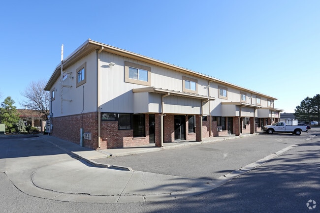
Property Record
695 Billings St, Aurora, CO 80011


Current Lease Availabilities
NEARBY LISTINGS FOR SALE OR LEASE
Property Detail
695 Billings St
Denver-Aurora-Lakewood, CO
I-225 Shopette Sub 3Rd Flg
1975-06-3-10-002
SUBDIVISIONCD 035716 SUBDIVISIONNAME I-225 SHOPETTE SUB 3RD FLG BLOCK 001 LOT 001 LOT 1 BLK 1 I-225 SHOPETTE SUB 3RD FLG
Warehouse
Arapahoe
X
Colorado
08005C0177L
001,1
2023
0.64 AC
2024
SW DIA/Pena Blvd
081800
Denver
10,194 SF
DEMOGRAPHICS near 695 Billings St
1 Mile
3 Mile
5 Mile
2024 Total Population
22,390
157,289
398,234
2029 Population
22,569
159,541
403,237
Pop Growth 2024-2029
+ 0.80%
+ 1.43%
+ 1.26%
Average Age
35
35
37
2024 Total Households
8,167
55,889
150,472
HH Growth 2024-2029
+ 0.94%
+ 1.48%
+ 1.30%
Median Household Inc
$56,884
$57,769
$66,914
Avg Household Size
2.60
2.70
2.50
2024 Avg HH Vehicles
2.00
2.00
2.00
Median Home Value
$337,682
$350,236
$382,247
Median Year Built
1982
1978
1983
Nearby Places
Map Layers
Map Styles
 Street
 Aerial
- Restaurants
- Banks
- Shops
- Fitness
- Groceries
PUBLIC TRANSPORTATION
COMMUTER RAIL
DRIVE
WALK
Distance
9 min
5.1 mi
DRIVE
WALK
Distance
9 min
5.1 mi
AIRPORT
Denver International
DRIVE
WALK
Distance
Denver International
22 min
16.8 mi
Nearby Properties
Address
Land Use
TOTAL SIZE
Lot Size
Zoning
Address
Land Use
TOTAL SIZE
Lot Size
Zoning
368,450 SF
48.59 AC
Address
Land Use
TOTAL SIZE
Lot Size
Zoning
353,829 SF
4.51 AC
Address
Land Use
TOTAL SIZE
Lot Size
Zoning
525,050 SF
105.06 AC
Address
Land Use
TOTAL SIZE
Lot Size
Zoning
496,493 SF
33.45 AC
Address
Land Use
TOTAL SIZE
Lot Size
Zoning
876,549 SF
46.65 AC
Address
Land Use
TOTAL SIZE
Lot Size
Zoning
868,780 SF
105.02 AC
Address
Land Use
TOTAL SIZE
Lot Size
Zoning
691,200 SF
38.09 AC
Address
Land Use
TOTAL SIZE
Lot Size
Zoning
273,184 SF
1.89 AC
Address
Land Use
TOTAL SIZE
Lot Size
Zoning
140.42 AC
Address
Land Use
TOTAL SIZE
Lot Size
Zoning
315,058 SF
36.85 AC
RPCZD
Address
Land Use
TOTAL SIZE
Lot Size
Zoning
269,622 SF
12.90 AC
Address
Land Use
TOTAL SIZE
Lot Size
Zoning
672,521 SF
0.61 AC
RB3
Address
Land Use
TOTAL SIZE
Lot Size
Zoning
277,985 SF
19.07 AC
Address
Land Use
TOTAL SIZE
Lot Size
Zoning
178,235 SF
1.38 AC
RFBAD
Address
Land Use
TOTAL SIZE
Lot Size
Zoning
201,600 SF
44.67 AC
R1
Address
Land Use
TOTAL SIZE
Lot Size
Zoning
331,923 SF
16.83 AC
Address
Land Use
TOTAL SIZE
Lot Size
Zoning
111,358 SF
1.21 AC
Address
Land Use
TOTAL SIZE
Lot Size
Zoning
277,005 SF
16.37 AC
Address
Land Use
TOTAL SIZE
Lot Size
Zoning
326,900 SF
16.21 AC
Address
Land Use
TOTAL SIZE
Lot Size
Zoning
142,708 SF
14.61 AC
Address
Land Use
TOTAL SIZE
Lot Size
Zoning
300,759 SF
54.34 AC
Address
Land Use
TOTAL SIZE
Lot Size
Zoning
364,024 SF
23.23 AC
PUD
Address
Land Use
TOTAL SIZE
Lot Size
Zoning
220,395 SF
7.93 AC
Address
Land Use
TOTAL SIZE
Lot Size
Zoning
386,285 SF
2.72 AC
Address
Land Use
TOTAL SIZE
Lot Size
Zoning
290,147 SF
22.02 AC
Address
Land Use
TOTAL SIZE
Lot Size
Zoning
366,800 SF
20.21 AC
Address
Land Use
TOTAL SIZE
Lot Size
Zoning
186,088 SF
10.15 AC
RZIND
Address
Land Use
TOTAL SIZE
Lot Size
Zoning
237,800 SF
13.86 AC
Address
Land Use
TOTAL SIZE
Lot Size
Zoning
176,751 SF
28.75 AC
The World's #1 Commercial Real Estate Marketplace
Connect with us
© 2025 CoStar Group
The information above has been obtained from sources believed reliable. While we do not doubt its accuracy we have not verified it and make no guarantee, warranty or representation about it. It is your responsibility to independently confirm its accuracy and completeness. Any projections, opinions, assumptions, or estimates used are for example only and do not represent the current or future performance of the property. The value of this transaction to you depends on tax and other factors which should be evaluated by your tax, financial, and legal advisors. You and your advisors should conduct a careful, independent investigation of the property to determine to your satisfaction the suitability of the property for your needs.